
Mt. Talamitam (630+)

 MT. TALAMITAM
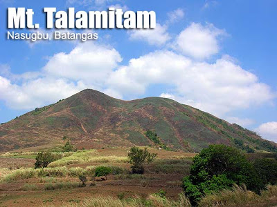
Nasugbu, Batangas
Jump-off point: Sitio Bayabasan, Brgy. Aga, Nasugbu (KM. 83)
LLA: 14.1158° N; 120.7577° N; 630 MASL
Days required/ Hours to summit: 1 day / 1.5-2.2 hours
Specs: Minor climb, Difficulty 3/9, Trail class 1-3 with steep assault (100m)
BACKGROUND
The same terrain of Mt. Batulao gives rise to its ‘younger sister’, Mt. Talamitam, on another side of Nasugbu, Batangas. Although it lacks the cool breezes and grand landscapes of Batulao, it is a surprisingly wondrous mountain on its own right, with verdant cogon grass during the rainy season, and a challenging, 60-degree trail before the peak.
 Talamitam is a mountain that had a more glorious past. It was named after the talamitam trees that used to grow on its slopes – a reminder of the time when Talamitam had lush vegetation and untarnished ecosystems. Today, it is a bald mountain, but efforts are underway to rehabilitate the peak with tree planting and other initiatives.
 The trail to Talamitam is easy, taking just 1.5 to 2.5 hours to complete the trek up to the summit. However, it can be a very exhausting hike if the sun is up, because there is little tree cover.
ITINERARY
0400 ETD Coastal Mall bus terminal to Nasugbu, Batangas (P120.00)
0700 ETA Registration area at Sitio Bayabasan, Brgy. Aga (KM. 83)
0730 Start trek
0930 Arrival at summit
1030 Start descent
1200 Back at registration area, head to Tagaytay or Manila
1300 Lunch at Tagaytay
1430 Head back to Manila
1700 ETA Manila
PRACTICALITIES: MT. TALAMITAM
|
Transportation
|
Public
(1) Bus, Coastal Mall to KM. 83 [P120, 2.5 hours] – isang sakay lang! Private (1) Head to Tagaytay either via SLEX-ETON Greenfield -Sta. Rosa or via Cavite (2) Follow through the road to Batangas, until you reach KM. 83. Make a right turn at the small side street past the school and look for parking space (available; give a ‘tip’ to the locals after) |
|
Registration (de facto)
|
Logbook at Brgy. Aga (P20/person).
|
|
Available; P300 per day. Expect to be ‘required’ to get a guide but you can try to talk your way out of it especially if you have hiked Talamitam before.
|
|
|
Ted Calimag (Brgy. Aga)+639477118513
Nick Wijangco – 09278248475
Nasugubu Police Station – (043) 931-9952
|
|
|
Campsites
|
At the base of the summit and at the summit itself
|
|
Water sources
|
None in normal course of trail except near the trailhead
|
|
Cellphone signal
|
Present throughout the trail
|
|
River crossings
|
Talamitam river near the jumpoff used to be crossed but there is now a bridge.
|
|
Roped segments
|
None
|
|
None
|
|
|
None
|
|
|
Rattan
|
None
|
|
Hiking notes
|
Caution when ascending the steep portion before the summit; there may be loose rocks. The blades of the talahib can cause ‘papercuts’.
|
|
Sidetrips
|
Nasugbu or Tagaytay; Twin dayhike with Mt. Batulao (see itinerary here)
|
|
Alternate trails
|
The old access point from Kayrilaw is still passable and some hikers have spoken of a traverse trail. Ask the locals first for permission before proceeding.
|
|
Yes (1.5-3 hours to summit; 1-2 hours down)
|
|
|
600-900
|
ADDITIONAL CONCERNS
Local context. Two parties have competed for jurisdiction or ‘caretaker’ status on Mt. Talamitam. Historically, Nick Wijangco, a local resident and artist, was the one who welcomed hikers and collected a registration fee. On the other hand, Ted Calimag, who heads the ‘Concerned Citizens of the Environment Movement’ (CCEM) has also claimed jurisdiction and is the de facto (as of 2013) caretaker of the mountain. PinoyMountaineer does not take positions in local disputes and leave it up to the locals to settle whatever differences they have.


TRIVIA
An optical illusion creates the impression that the peak on the right side of the summit is higher ground. This is not true; the highest point in Talamitam is where the trail ends.
PINOYMOUNTAINEER IN MT. TALAMITAM
Hiking matters #133: Twin Dayhikes – Talamitam and Batulao
Hiking matters #266: A verdant Mt. Talamitam
Hiking matters #391: A morning hike up Talamitam


Leave a Reply
246 Comments on "Mt. Talamitam (630+)"
Hi PinoyMountaineer…
We've been to Mt Talamitam yesterday (04/25/15), just an update, guide is still fixed at 300/day but the registration fee rose up to P30/person.
Before the trek, you will be listed for monitoring purposes where you can also secure guides and will pay the registration fee once you descended. Guides are from Sitio Bayabasan of Brgy. Aga but the registration fee is collected by the other Barangay where summit is part of their realm.
Our guide was likewise staggered to find out that registration fee has increased as they were not informed of the changes.
Other than that, trekking Mt. Talamitam is worthwhile for it offfers a grandeur mountain scenery with Grotto present at the summit.
Happy Trekking…
JRJ
Day hike on Sunday. 'ta kits!
san po ang dbest na jump off to talamitam?plano po namin mag mt.talamitam and then mt. batulao this june 28 2014.
sana may sumabay pa na ibang group.txt me on this number. 09277973227 marc
Update lang po.
Mt. Talamitam, guide not required na po. Kakaakyat lang namin nung end of may, nighthike. Kahit yung mga naka salubong namin ng morning, wala na ding guide.
Sa mga mag nntighthike po pala ng talamitam, beware of aggressive cows and horses.. hehe!!
Pasensya na po sa late post.
04.26.14 Talamitam Update
We went to talamitam for an overnight camping with hopes of having a clear sky for some stargazing. luckily the weather cooperated blessing us with a clear sky. the trail is still straight forward and can be really hot on daylight.
The only problem we encountered was there was a man called mang Herman who apparently has a psychological disorder who attacked our group by throwing things at us. what scary about this incident was mang Herman was carrying a bolo on his other hand. Locals told us about the story of mang Herman. Mang Hermans lack of sanity came from his previous vices and also that his family was once used to own a large portion of land but unfortunately it was already sold by his other siblings. This is the reason why he is attacking people on trail because he thought that their family still owns the land. just be wary about this person and be sure to be quick when you encounter him.
aside from mang Herman locals also says that the jumpoff will be transferred to barangay Kerilao due to lack of progress on the current location despite of collecting fees.
aside from minor encounters; Mt. Talamitam is still very nice mountain for beginners.