

Mt. Talinis/Bediao-Apolong Traverse to Casaroro Falls (1,903+)


MT. TALINIS (BEDIAO-APOLONG TRAVERSE)
Dauin and Valencia City, Negros Oriental
Entry point: Brgy. Bediao, Dauin
Exit point: Brgy. Apolong, Valencia City
LLA: 1903 MASL
Days required / Hours to summit: 2-3 days / 10-11 hours
Specs: Major climb, Difficulty 6/9, Trail class 2-4
Features: Lakes, waterfalls, mossy forest
BACKGROUND
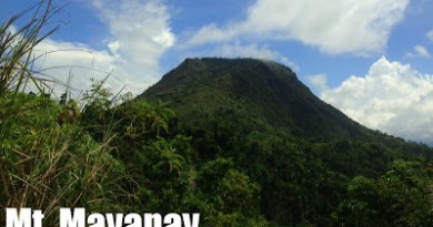
A longtime favorite Visayan destination of mountaineers is Mt. Talinis in Southern Negros, otherwise known as “Cuernos de Negros” for the horn-like peaks that highlight the mountain. It holds its position as the second highest mountain in Negros, next only to the lofty Kanlaon.
It is not surprising that Talinis is the only mountain other than Mt. Apo to have become twice the venue of the annual MFPI Federation climbs, among other activities. Its only impediment is the perennial rumor of NPA presence, but as of 2009, it is perfectly safe to climb Talinis.
There are several trails but the most typical, and comprehensive enough, route is a traverse from the Bediao trail in Dauin, Negros Oriental, to Apolong. The roster of places to see is formidable: first is Lake Yagumyum with the optional ascent to Yagumyum Peak; then, passing by the mystical maribuhok forests, one reaches the higher and grander Lake Nailig. From this lagoon there is again the option to scale Nailig Peak, otherwise known as Talinis Dako i.e. the highest point in the mountain. Finally, on the way down via the Apolong Route, pass by the sulphuric river and the Twin Falls of Talinis before ending in the grand cascade of Casaroro Falls, the highest in Negros at over 90 meters. A destination by itself, Casaroro Falls is a fitting conclusion to the Talinis experience.
ITINERARY
Bediao-Apolong route from Dumaguete City
Day 1
0600 From Dumaguete, take Ceres minibus to Dauin
0700 Get off at plaza; arrange habal-habal to Geothermal Site, Bediao
0730 ETA jumpoff. Start trek
1200 ETA Lake Yagumgyum. 30-minute assault to Yagumyum Peak
1330 Back at Lake Yagumyum, proceed to Lake Nailig
1700 ETA Lake Nailig; set up camp
1800 Dinner / socials
Day 2
0500 Talinis summit assault
0700 ETA summit
0730 Head back to Nailig campsite
0900 Start descent
1200 ETA Sulfuric River
1500 ETA Casaroro Falls; sidetrip
1900 Back in Dumaguete
NOTE: the two peaks can be discarded for a lighter itinerary. Also, this same itinerary can be spread over three days.
SPECIAL CONCERNS
Mt. Talinis is one of the remaining mountains under the care of a local mountaineering club, in keeping with old mountaineering tradition. The Cuernos de Negros Mountaineers, Inc. (CNMCI) based in Siliman University, Dumaguete, has maintained a close and fruitful relationship with the mountain and they are the best contact when planning a Talinis climb.
Transportation. To go to Talinis, the staging-off point is Dumaguete City. There are at least a few flights daily. Fares range from 3000-6000 roundtrip. Or, take the six-hour trip from Bacolod to Dumaguete (~P180). From Dumaguete take a tricycle to the Ceres bus terminal and take the minibus to Dauin. From Dauin municipality take a habal-habal up the mountain to the jumpoff in Bediao Geothermal Site. At the other end – you can take a habal-habal from the Casaroro Falls junction to Valencia town proper, where jeepneys will take you back to Dumaguete. Here don’t fail to appreciate a nice view of Talinis.
Climbing notes. It is safe to swim on both lakes Yagumyum and Nailig although the latter is cleaner albeit colder. You can also swim in the pools of Casaroro Falls. Cellphone signal is sporadic on the trail but it is present in the Maribuhok-Nailig leg of the trail. Water sources are available in the two lakes as well.
PICTURES OF MT. TALINIS AND CASARORO FALLS
The start of the trail is an exposed slope, lending an expansive view of the southern Visayan seas.

Behold the tranquility of Lake Yagumyum, the first ancient crater lake to be encountered in the trek.

Between the two lakes stands a ridge of grand, mossy, ancient maribuhok trees.

Lake Nailig is the setting of one of the most scenic and cold campsites in the Visayas.

The finale of the traverse is swimming and sightseeing in the realm of Casaroro Falls, the tallest waterfalls in the Visayas.
TRIVIA
Beside Lake Nailig is another lake called Lake Mabilog. It has a pecuiliar rounded shape and is said to be the hideout of snakes.
Mt. Talinis is the third mountain in the Visayan Voyage. A narrative of the blogger’s trip to Talinis will be published in Manila Bulletin on July 25, 2009.
PinoyMountaineer thanks the Cuernos de Negros Mountaineering Club, Inc. for hosting the blogger and the Visayan Voyage Team in Mt. Talinis on April 9-10, 2009. Images courtesy of Lalaine Hablado, Julian Canero, and Jacob Sarreal.

Leave a Reply
66 Comments on "Mt. Talinis/Bediao-Apolong Traverse to Casaroro Falls (1,903+)"
Did a two-day traverse climb starting from Brgy. Apolong to Bediao as exit point last May 25-26. Camped at Racho "Camote" for the night as suggested by our british instant expedition companion Alex – we've met him at Casaroro Falls entrance. Me and my climb buddy Bok had conceded since we are tired already (or maybe just me ^__^) due to lack of sleep, we took a very early flight and came straight from the airport that day, made a stopover at the Tourism office of Valencia to make a personal appareance to Sir Joven and also to buy some food stuff.
Anyway, I think our foreign guest had enjoyed our dinner of grilled chicken, rice and steamed camote tops (w/c you can find abundant at the rancho, hence we called it Racho Camote) with onions and tomatoes hehehe. Aside from Bok, Alex and our guide Kuya Adong, we were also joined by Kuya Leleng during the dinner ala boodle feast. He's the one who cooked the chicken, met him during my talinis dayhike last year. He is one of the forest guards stationed at Talinis.
Talinis is one of the best climbs I've ever had – worthy enough para balikan ko sya :). It features falls, rivers(incl the sulfuric one at Kaipuhan), dense forest(I really enjoyed walking through the mossy forest), lakes/old volcanic craters – Nailig, Yagumyum, Mabilog and Halawig, and some very challenging 4×4 trails 🙂
We even witnessed some smoke steam at the far side of Yagumyum lake.
It's mission accomplished for me but I'm planning to go back to do the traditional traverse climb, Bediao to Apolong, and to experience camping at Nailig Lake. When? I don't know yet….
– Mina
Will definitely go back to this place and try to reach some of those cuernos. Did a dayhike up to Kaipuhan Volcano last October, I enjoyed the climb, busog ang mata ko sa dami ng magagandang spots. Luckily I have a guide that knows place well. He happens to be a forest ranger in Talinis Area ☺ – Mina
Will definitely go back to this place and try to reach some of those cuernos. Did a dayhike up to Kaipuhan Volcano last October, I enjoyed the climb, busog ang mata ko sa dami ng magagandang spots. Luckily I have a guide that knows the place well. He happens to be a forest guard in Talinis Area ☺ – Mina
Sorry for My Post.. D ko nilagyan nang contact #..It's ME.. Ralph contact me 0356211782.. Ako po ang Nag post about sa Open Climb sa SES-MC October 11-13.. Thanks 🙂
Good Evening Sir/Maa'm.
Merun po kaming Open Climb this Coming October 11-13 2014.. Climb for a Cause.. To Save Mt. Talinis.. Kasi Ilang Buwan lang nakakalipas mayroon pong almost 600 Trees na pinutol sa bundok at ginawang daanan nang sasakyan nang Private Company..
Limited Slots lang po.. 30pax. Bedjao Traverse Apolong Trail.. Thank You..
SES-MC..