
Hiking matters #267: Hiking up Mt. Buntis and visiting Mt. Nagpatong in Andres Bonifacio’s Maragondon


Today, Coby Sarreal (@cobysarreal) and I decided to visit Maragondon, Cavite, to see what possibilities lie in that historic town for hiking. Both Pico de Loro and Mt. Marami are actually claimed by Maragondon as under their jurisdiction, and indeed, both these peaks are part of the Maragondon Range.

Our peaks of interest for today, however, draw from history: Mt. Buntis and Mt. Nagpatong are well-known for being the site execution of the revolutionary leader Andres Bonifacio. This is the subject of bitter debate among historians and pundits, but for me, it will suffice to say that the execution, which took place in May 10, 1897, was a dark moment in our history.

We took a Naic-bound bus along Taft and headed straight to Maragondon (P80). At Maragondon, we were warmly received by town officials, who spoke of over 20 other peaks in the town, including a certain Mt. Nagputok which is said to possibly have volcanic features. The counting of peaks, however, is always debatable. What constitutes a distinct mountain?

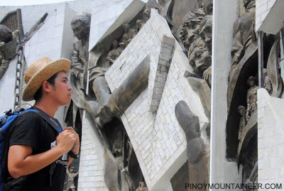
Anyway, we first went to Andres Bonifacio’s shrine in Mt. Nagpatong; there is no trekking required to reach the shrine, which is accessible by any vehicle willing to brave the rough roads. Here, there are walls that depict scenes in Bonifacio’s life and final days – truly his execution was a dark moment in Philippine history.

While going about town, the tricycle driver pointed to us what he thinks is Mt. Buntis: it is just a little bump in the range, but I cannot verify this. We had lunch at Lolo Claro’s Restaurant, which served great food at reasonable prices! Coby and I agreed that we should eat there after the climb as well! We stayed at the restaurant until 1300H, as we didn’t want to start trekking under the midday sun.

We then proceeded to the Kaingin Hanging Bridge, which is practically the jumpoff for Mt. Buntis. This is walkable from the municipal hall but a trike ride will just cost P10 per person. A local youth, Maynard, offered to guide us, for P300. However, he conceded that he is not really an expert in the trails; very few people visit the mountain nowadays.

We crossed the hanging bridge. Initially, the trek passed through wooden houses and agricultural fields, and as you walk past them, you can really see a slice of life in a rural community: men with their beasts of burden, transporting felled wood and bamboo trunks; or women with their harvests of vegetables.

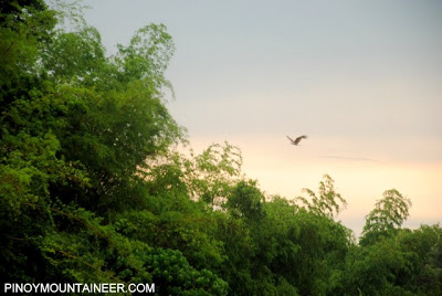
After 30-40 minutes through these fields, the trail enters a forest akin to those of nearby Pico de Loro, though with less forest trees. Though the forest was not expensive, I was impressed by the variety of birds, and I even spotted a monkey. This is indeed a relatively pristine forest with an ecosystem that is still vibrant and active.

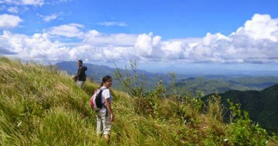
Some parts were moderately steep, but the trail was generally easy. We passed through at least two bamboo gates that are intended to keep the cattle from roaming beyond their assigned territories. It rained a bit while we were on this part, so I was not able to take pictures. Finallly, after another 40 minutes, we arrived at the ‘Dungawan’, the summit of Mt. Buntis.

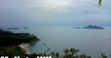
At the viewpoint, which concludes the usual trek (although we went beyond to a higher ground, just 15 minutes further up), the view is breathtaking, if only for Mt. Mariveles, whose presence towers above Manila bay beneath. I’m sure on a clearer day, much more could be revealed, but the sight of Pantingan Peak and Bataan Peak sufficed to make my day!

It took us an hour to descent; it had rained and the trails have turned muddy, hampering our progress a bit. Nonetheless, I felt triumphant, as I knew that I have discovered for myself another nice dayhike destination! Definitely, I will highly recommend Mt. Buntis. Back in Marangondon, we dined at Lolo Claro’s again, as we promised ourselves, and finished in time for the last trip (1800H) back to Manila!

Endnote: The Mt. Buntis and Mt. Nagpatong itinerary is now updated, based on my experiences in this trip! Check it out by clicking this link. Another nice account of Mt. Buntis can be found in Ivan Lakwatsero’s blog.
THE BLOGGER’S HISTORICAL HIKES
Hiking matters #36: A note from Tirad Pass
Hiking matters #36: A note from Tirad Pass

Leave a Reply
7 Comments on "Hiking matters #267: Hiking up Mt. Buntis and visiting Mt. Nagpatong in Andres Bonifacio’s Maragondon"
Maaari ko po bang mahiram ang inyong picture (yung sa may ibon po) para po sa aking online advocacy na naglalayong i-preserve ang Maragondon mountains maging ang mga species na narito.? sana po ay mapagbigyan niyo ako; malaking tulong po kung mapagbibigyan niyo ako.
Good afternoon, may I borrow the picture you used here? The two with birds in the shot? 🙂 I am a Journalism stude po and together with my classmates, we are running a page concerning preservation of Maragondon Mountains, especially the species within such. Thus, we aim to feature species like what you have here in your blog. Sana po ay maipahiram po ninyo. Salamat po and more power.
sir, typo error po ata sa title. lagot po tayo kay supremo nyan. hehe 🙂
may aakyat po ba this week end s mt buntis n nag ptong .pwede p bang mkisabay.09152558476
Rol
aborted ang climb ko dito sa Mt. Buntis during bagyong Ondoy (2009).
nagbackout lahat ng kasama ko kasi sobrang lakas ng ulan. hindi ko ineexpect na malakas talaga ang ulan at wala na din akong masakyan (nasa lugar pa namin ako).