
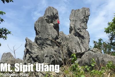
Mt. Sipit Ulang (252+) in Rodriguez, Rizal


MT. SIPIT ULANG
Rodriguez, Rizal
Major jumpoff: Brgy. Mascap, Rodriguez, Rizal
LLA: 14°45′20.7′′ N, 121°10′38.2′ 252 MASL (+210m)
Days required / Hours to summit: 1 day / 2-3.5 hours
Specs: Minor, Difficulty 3/9 (Paniki Trail), Trail class 1-4 with limestone scrambling
Features: Limestone formations, scenic views of Wawa
Article history: Created August 31, 2015
Author: Gideon Lasco
BACKGROUND
Yet another hiking destination in Rodriguez, Rizal is Mt. Sipit Ulang in Brgy. Mascap. This mountain, which literally means “crab’s claw”, is named after the claw-like rock formation at its pinnacle. Like many of the newly-discovered mountains in Rizal, Mt. Sipit Ulang features limestone trails and spectacular scenery at the top.
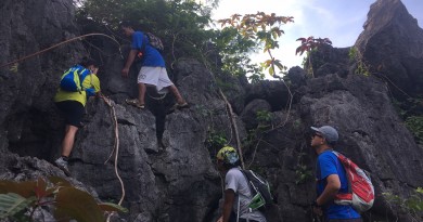
 The mountain has two trails. The premiere – and relatively new – trail is called the Paniki Trail, named after the bats that dwell inside the cavernous structures under its rock formations. This very rocky trail features cave-like passages which require a bit of scrambling and some acrobatics on the part of the hiker, but is surprisingly well-conceived, with a ladder in tow in one of its most exciting parts. This is our recommended ascending trail, taking 2-3 hours to reach the top.
At the summit, the highlight is a view of the three rocky mountains of Wawa: Hapunang Banoi, Pamitinan, and Binacayan. Mt. Ayaas looks more proximate – there is actually a trail from Brgy. Mascap that goes to Mt. Ayaas! So it is very possible to do Sipit Ulang first, Ayaas next, then traverse to Wawa to do its three mountains the next day for a five-mountain weekend!
A much easier trail is the Banayad (Easy) Trail, a shorter route which avoids the rocky parts and goes straight to the summit. A traverse, going up Paniki and descending down the Banayad Trail, is recommended. Sidetrip possibilities include a visit to the multi-level Payaran Falls, while guides speak of many other outdoor destinations waiting to be discovered.
ITINERARY
MT. SIPIT ULANG DAYHIKE
0400 Take van from Cubao to Eastwood, Rodriguez, Rizal
0530 ETA Rodriguez, Rizal; take trike to Brgy. Mascap
0630 Arrival at Brgy. Mascap. Register at barangay hall
0700 Start trek up Hapunang Banoi via Paniki Trail
0930 ETA summit. Explore rock formations
1000 Retreat to the benches – possible lunch stop*
1030 Start descent via the Banayad Trail
1200 Back at Brgy. Mascap. Tidy up.
1300 Head back to Rodriguez town (or proceed to Mt. Ayaas)
1400 Back in Eastwood, Rodriguez. Take van back to Manila
1530 Back in Manila.
MT. SIPIT ULANG +PAYARAN FALLS DAYHIKE
0400 Take van from Cubao to Eastwood, Rodriguez, Rizal
0530 ETA Rodriguez, Rizal; take trike to Brgy. Mascap
0630 Arrival at Brgy. Mascap. Register at barangay hall
0700 Start trek up Hapunang Banoi via Paniki Trail
0930 ETA summit. Explore rock formations
1000 Retreat to the benches – possible lunch stop*
1030 Start descent via the Banayad Trail
1200 Back at Brgy. Mascap. Lunch
1300 Explore Payaran Falls (~45 min. trekking time)
1600 Back again at Mascap. Tidy up.
1630 Head back to Rodriguez town (or proceed to Mt. Ayaas)
1730 Back in Eastwood, Rodriguez. Take van back to Manila
1900 Back in Manila.
PRACTICALITIES: MT. SIPIT ULANG
|
Transportation
|
Public (1) Van, Cubao to Montalban (Eastwood) [P50; 1-1.5 hours]
(2) trike, Montalban (Eastwood) to Brgy. Mascap [Fare to be verified; 30 mins]Alternatively, take any transport to Montalban (i.e. via Marikina) then take (2) Approximately 2-2.5 hours travel time because of various stops and delays. Private. Head out to Rodriguez, Rizal via Marikina and San Mateo, then follow the road to Wawa Dam. From the bridge in Marikina River, turn right and ask around for the Mascap-Puray Road which leads to the barangay. Approximately 1.5-2.5 hours travel time. |
|
Registration
|
(1) Logbook at the barangay hall
No fixed fees at the moment, a donation of P20 is suggested. |
|
Available; assigned at the barangay hall. No fixed rates but P400/day is suggested (add more if doing a twin dayhike with Mt. Ayaas.
|
|
|
(0998) 346 0676- Mascap tourism
|
|
|
Campsites and waypoints
|
Camping is possible in some of the desginated areas. Be mindful though that there are no water sources beyond the brooks. Check with guides.Waypoints
(1) Mt. Sipit Ulang Summit 14°45′20.7′′ N, 121°10′38.2′ 252 MASL |
|
Water sources
|
None past the brooks
|
|
Cellphone signal
|
Strong at the summit (+LTE) but not consistent throughout the trail
|
|
River crossings
|
One crossing in the Paniki Trail
A few at the Banayad Trail |
|
Roped segments
|
None but some hikers may require assistance in some of the rocky formations.
|
|
None
|
|
|
None
|
|
|
Rattan
|
Some
|
|
Hiking notes
|
Be very cautious when hiking during the rainy season or during/after heavy rains
|
|
Sidetrips
|
|
|
Alternate trails
|
See above for the two trails. Those who want an easier ascent may opt to take the Banayad Trail up and down.
|
|
Yes
|
|
|
Facilities at jumpoff
|
(+) Sari-sari stores
(+) Free parking (+) Wash-up / shower places (pakiusap w/ private houses) |
|
500-700 (dayhike)
800-1000 (overnight) |
MT. SIPIT ULANG PICTURES
 |
| The limestone formations at the onset of the trail |
 |
| There are a handful of small brook crossings |
 |
| Some parts of the trail are very narrow |
 |
| The “Paniki” Trail offers challenging sections above and beneath rock |
 |
| At the summit of Mt. Sipit Ulang with the three Wawa mountains, Hapunang Banoi, Pamitinan, and Binacayan at the background |
 |
| At the summit of Mt. Sipit Ulang |
TRIVIA
According to local guides, there are over a hundred caves in the area, some of which have historical value as hiding places of rebels.
Mt. Sipit Ulang is the seventh mountain of Rodriguez, Rizal to have an itinerary in Pinoy Mountaineer (after Pamitinan, Binacayan, Lubog, Ayaas, and Hapunang Banoi).
The thrust towards documenting and featuring mountains in the near-Sierra Madre is in line with our thrust of combating destructive mountain practices through ecotourism.
The blogger hiked Mt. Sipit Ulang in August 29, 2015. Credits to Jacob Sarreal for organising this hike and to Ram Ng for some of the photos.
THE MOUNTAINS OF RODRIGUEZ, RIZAL
Mt. Ayaas
Leave a Reply
5 Comments on "Mt. Sipit Ulang (252+) in Rodriguez, Rizal"
Is it safe for an all women group?
For now they are requiring to have a guide especially if there are women in the group. Based on the discussion I had with our guide there's a maximum of 3 to 4 persons per guide.
Very nice new place and very accommodating locals. I've been there few weeks ago – maybe next time I'll try the Paniki trail. You'll not regret a refreshing side trip to the seven-series Payaran waterfalls and the secret lagoon.
like sir joshua bonete, ask ko rin kung required po ba ang guide? TIA
Required po ba ang guides?