
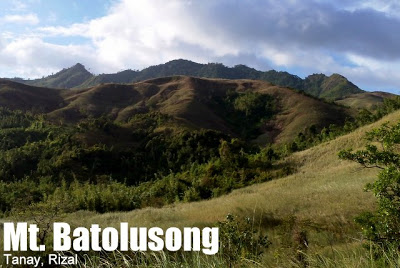
Mt. Batolusong/Mapatag Plateau and Susong Dalaga Peak (645+/780+)


MT. BATOLUSONG (MAPATAG & SUSONG DALAGA)
Tanay, Rizal
Major jumpoff: Brgy. San Andres, Tanay, Rizal*
LLA: 645 MASL / 780 MASL
Days required / Hours to destination: 1 day /1.5h (Mapatag); 3-4 (Susong Dalaga Peak)
Specs: Minor climb, Difficulty 3/9, Trail class 1-3
Features: Grassland slopes, views of Laguna, Rizal, and Quezon
Article history: Created February 2, 2013
*Note: The major jumpoff used to be Sitio Kay-ibon, Brgy. Cuyambay. However, for the moment (February 2013), this entry point is closed according to the local authorities.
*Note 2: This itinerary is under development. You can contribute to the content of the article and the design of the itineraries by commenting.
BACKGROUND
Mt. Batolusong is one of the ‘latest hits’ in the local hiking scene, its proximity to Manila spurring a spate of interest in the mountain in 2012 and onwards. It is located between Brgy. Cuyambay and Brgy. San Andres in Tanay, Rizal, pretty much in the same direction as Sta. Ines, the jumpoff of the more popular and more difficult Mt. Irid. It is often compared to nearby Mt. Sembrano, because of some similarities in the two mountains’ grassland slopes; Batolusong may be thought of a ‘closer and easier’ version of Sembrano.
Mt. Batolusong is just one of the many potential hiking destinations in Tanay, since the town is part of the southern tailend of the Sierra Madre, the longest mountain range in the Philippines. The fact that there has been a lot of interest about this mountain augurs well for an ‘eastern push’ in explorations that can very well see more outlying Sierra Madre peaks becoming popular hikes – either as dayhikes or overnighters – from Manila.
Previously, the recommended jumpoff was Sitio Kay-ibon, Brgy. Cuyambay, just along the Marcos highway. However, since entry using this trailhead has recently been prohibited by local authorities. For this reason, I am adopting Brgy. San Andres as the major jumpoff in this itinerary. Moreover, the trail is very nice from San Andres, passing through some interesting rock formations, and featuring a nice ascent through woodlands up to the Duhatan Ridge leading to Mapatag Plateau.
Mapatag Plateau (645m) can be the final endpoint of the hike; it is a grassland slope that serves as a scenic viewpoint and a possible campsite. Actually, for some locals, “Batolusong” refers to this plateau and the valley next to it. However, it is also possible to go to Susong Dalaga Peak (780m est.) which takes about two hours from Mapatag Plateau according to our San Andres-based guides Boboy and Michael. The itinerary below anticipates various preferences. Should the Sitio Kay-ibon Trail open, a traverse is very possible from San Andres, and vice-versa. Moreover, Kay-Ibon Falls, a little farther off the trail, is a nice detour. Surely, there are many other possibilities in the area!
ITINERARIES
Batolusong (Mapatag Plateau) Dayhike
0500 Leave Manila for Antipolo City (Cogeo Gate 2)
0600 ETA Cogeo Gate 2; Take jeep to Brgy. Sampaloc
0730 Drop off at ‘Batangas’; take habal-habal to Brgy. San Andres
0800 ETA Brgy. San Andres; courtesy call to local officials / get guides
0830 Start trek
0945 Arrival at Duhatan Ridge (590m)
1000 Arrival at Mapatag Plateau (645m)
1030 Start descent
1145 Back in Brgy. Sampaloc. Tidy up / Lunch
1230 Head back to ‘ Batangas’.
1300 ETA ‘Batangas’ junction; Wait for return jeepney
1430 Back at Antipolo City. Take jeep/bus back to Manila
1600 ETA Manila
Batolusong (Mapatag Plateau and Susong Dalaga) Dayhike
*Note: This is a theoretical itinerary based on my guides’ estimates of hiking time up Susong Dalaga Peak. For best results, you may want to try this out first with private transportation so as to maximize time and not jeopardize your return to Manila
0500 Leave Manila for Antipolo City (Cogeo Gate 2)
0600 ETA Cogeo Gate 2; Take jeep to Brgy. Sampaloc
0730 Drop off at ‘Batangas’; take habal-habal to Brgy. San Andres
0800 ETA Brgy. San Andres; courtesy call to local officials / get guides
0830 Start trek
0945 Arrival at Duhatan Ridge (590m)
1000 Arrival at Mapatag Plateau (645m)
1015 Start assault to Susong Dalaga Peak
1230 ETA Susong Dalaga Peak / Lunch
1300 Start descent
1430 Back in Mapatag. Continue descending
1540 Back in Brgy. Sampaloc. Tidy up
1600 Head back to ‘ Batangas’.
1630 ETA ‘Batangas’ junction; Wait for return jeepney
1800 Back at Antipolo City. Take jeep/bus back to Manila
1930 ETA Manila
Batolusong (Mapatag) Traverse + Kay-ibon Falls Sidetrip
Day 1
0900 Leave Manila for Antipolo City (Cogeo Gate 2)
1020 Buy supplies in Antipolo
1100 Early lunch / Take jeep to Brgy. Sampaloc
1300 Arrival at ‘Batangas’; take habal-habal/jeep to Brgy. San Andres
1330 ETA Brgy. San Andres; courtesy call to local officials / get guides
1400 Start trek
1545 Arrival at Duhatan Ridge (590m)
1615 Arrival at Mapatag Plateau (645m). Set up camp
1800 Dinner / socials
Day 2
0600 Wake up call
0700 Breakfast
0800 Break camp
0830 Start descent
1000 Arrival at Kay-Ibon Falls
1100 Proceed to Sitio Kay-ibon – Marcos Highway
1130 Arrival at highway; end of trek / Tidy up
1200 Wait for return jeepney
1330 Back at Antipolo City. Take jeep/bus back to Manila
1500 ETA Manila
Batolusong (Mapatag) Overnight
Day 1
0900 Leave Manila for Antipolo City (Cogeo Gate 2)
1020 Buy supplies in Antipolo
1100 Early lunch / Take jeep to Brgy. Sampaloc
1300 Arrival at ‘Batangas’; take habal-habal/jeep to Brgy. San Andres
1330 ETA Brgy. San Andres; courtesy call to local officials / get guides
1400 Start trek
1545 Arrival at Duhatan Ridge (590m)
1615 Arrival at Mapatag Plateau (645m). Set up camp
1800 Dinner / socials
Day 2
0600 Wake up call
0700 Breakfast
0800 Break camp
0830 Start descent
1000 Back at Brgy. San Andres. Tidy up
1100 Take jeepney/habal-habal back to highway
1130 Wait for return jeepney
1300 Back at Antipolo City. Take jeep/bus back to Manila
1430 ETA Manila
PRACTICALITIES
Transportation. From Manila (i.e. Cubao) head to Antipolo City, particularly to the Cogeo Gate 2 terminal. The Cogeo Gate 2 jeepney is the same jeep that hikers take to Mt. Irid. Get off at ‘Batangas’ junction where there is an entrance arch for Brgy. San Andres. Take a habal-habal to the barangay (P70/trip).
Registration and guides. Right now, it is uncertain. Under the old setup, hikers are asked to register at the PSD Outpost in Sitio Kay-ibon. With this new trailhead, the logical registration point is the barangay hall or with the barangay officials of Brgy. San Andres. However, it is also very possible that municipality of Tanay may demand that hikers get a permit from them as well. Considering the history of insurgency in Rizal province, this is very understandable but I hope they do not impose it since it will be very inconvenient for hikers if they will have to go all the way to Tanay proper.
As for guides, look for Boboy and Michael; they both know the way. Unfortunately there is no cellphone signal in Brgy. San Andres and thus no way to reach them other than just going there. P400/day is a reasonable rate for guideship; or P600/day for two guides if the guide insists on having a companion.
Hiking notes. The Sapa ng Batolusong is the clear stream that one would pass through prior to the end of the trail using the Sitio Kay-ibon Trail. Some accounts like this good resource say that this river swells during the rainy season.
Camping notes. There are no water sources in Mapatag Plateau and for most of the trail. Cellphone signal is present in Mapatag but not in the trailhead or most parts of the trail.
Security concerns. There are some reports of theft in the past so hikers are advised to be careful.
MT. BATOLUSONG PICTURES
 |
| Ricefields at the start of the trail from Brgy. San Andres, Tanay, Rizal |
 |
| Rock formations along the San Andres trail up Mt. Batolusong |
 |
| Duhatan Ridge is so named after the duhat trees that grow in this beautiful ridgeline |
 |
| The blogger at Mapatag Plateau, February 2, 2013 |
 |
| The ‘Sapa ng Batolusong’ is a small creek near the Sitio Kay-ibon trailhead |
TRIVIA
The blogger’s hike up Mt. Batolusong will be narrated in Hiking matters #325.
Leave a Reply
23 Comments on "Mt. Batolusong/Mapatag Plateau and Susong Dalaga Peak (645+/780+)"
Update po please 😀
Update please 😀
Pa update po thanks
Upa update naman po thanks
Hey there! I am planning to bring my classmates at Mt. Batolusong for a hiking activity. Can someone give me a contact number of a tour guide so I can ask for my further inquiries ?
Thanks in advance ! =)