
Pico de Loro (664+) [CLOSED]

PICO DE LORO
Maragondon, Cavite and Nasugbu, Batangas
Major jump-off: DENR Station, Magnetic Hill, Ternate, Cavite
Minor jump-off: Sitio Fronda, Brgy. Papaya, Ternate-Nasugbu Highway, Nasugbu, Batangas
LLA: 14° 12.855 N; 120° 38.785 E; 664 MASL
Days required / Hours to summit: 1-2 days / 2-5 hours
Specs: Minor climb, Difficulty 3/9, Trail class 1-3
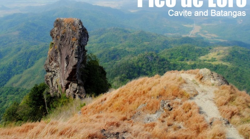
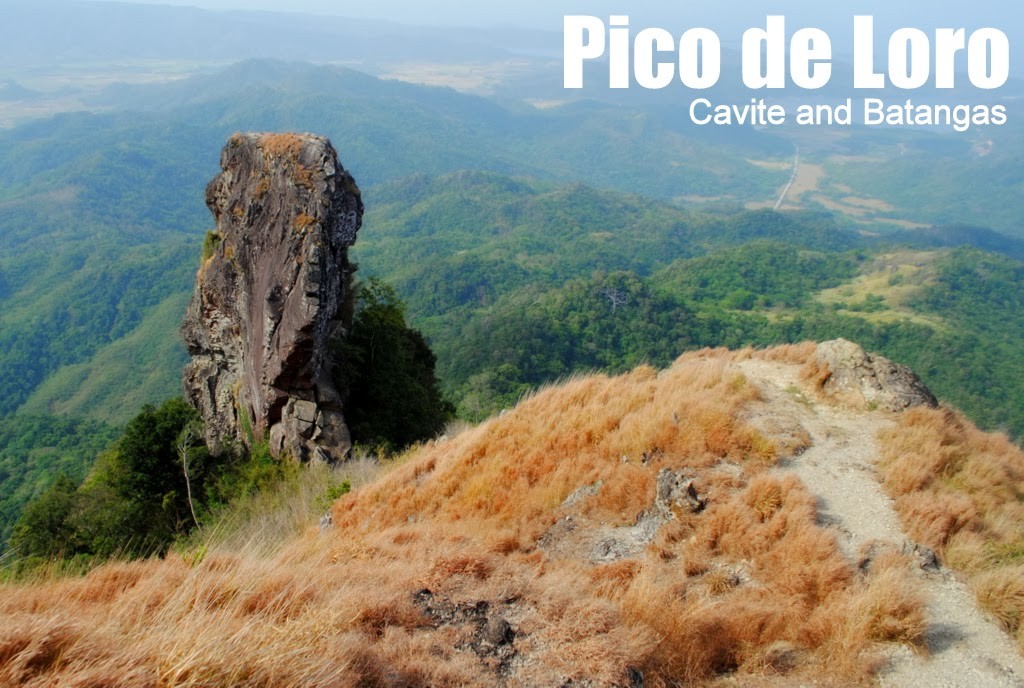
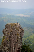
Features: Distinctive spire at the summit, forests, scenic views of Cavite
Last updated: September 16, 2016
Pico de Loro will be indefinitely closed starting on October 1, 2016. See this Mountain News article for more details.
BACKGROUND
Centuries ago, the Spaniards aboard their galleons to Manila Bay noticed the form of a giant parrot, perched in the forested mountains in Cavite. They named it “Pico de Loro” – “Parrot’s Peak” Today, mountaineers who visit Pico de Loro discover that it is as enchanting as its name. High on Cavite’s highest point, they could behold the rocky tower that the Spanish sailors once saw as the parrot’s beak, and they could gaze towards South China Sea where the galleons once sailed, all the way to the historic island fort of Corregidor. Gusts of sea breeze reach the peak, refreshing hikers after a four-hour climb. The peak’s rocky outcropping is dramatic, and sharply contrasts with the plains of Cavite and the waters of South China Sea.
 Such an experience is only the highlight of a trip to Pico de Loro, which is located on a DENR Protected Area. Nestled near the beaches of Cavite such as Puerto Azul and Caylabne, it is actually part of a small mountain range known as Mt. Palay-Palay. Readily accessible by bus from Manila, Pico de Loro has gained fame as a perfect weekend getaway. Even during the dry season, its forests protect hikers from the sun. Sometimes you can even chance upon exotic birds and monkeys along the trail.
On rainy days, instead of the aforementioned views, you will experience a serene windscape: of clouds surging past you, and tiny rain particles brushing across your face like a massage.The option to go down via Nasugbu, Batangas, is increasingly used, and is now made easier with the Ternate-Nasugbu Highway, which cuts the trail for 30-60 minutes. From this highway, a jeepney can pick you up or you can hitch a ride to Nasugbu, where one can easily take a bus to Manila.
0400 Board bus at Coastal Mall Terminal to Ternate (P82)
0700 ETA Ternate. Rent jeepney or tricycle to jumpoff
0745 ETA DENR / jump-off point. (P25 registration)
0800 Start trek.
0945 Reach highest point of the New Trail
1000 Arrival at junction with Old Trail
1030 ETA campsite
1230 start descent to Magnetic Hill
1430 Back at DENR; take jeep/trike to Ternate then take bus back to Manila
1230 start descent to Nasugbu-Ternate Highway
1530 ETA Nasugbu-Ternate Highway.
2100 ETA Manila.PRACTICALITIES: PICO DE LORO
|
Transportation
|
Public (1) Bus, Coastal Mall to Ternate terminal [P82, 1.5 hours]
(2) Tricycle or jeep, Ternate terminal to DENR trailhead [P250/way for trike]Private: Take CAVITEX or Aguinaldo Highway all the way to Naic, Cavite, then follow the way to Naic, then follow the signs to Puerto Azul, go past the resort, and park at the DENR Outpost you can see on the left. Parking space is available at the outpost. |
|
Registration
|
Logbook at trailhead; P25 fee
|
|
Available but NOT required in the New Trail.
|
|
|
Jeep Rental – 09175956140
|
|
|
Campsites
|
At the base of the summit (>15 tents)
|
|
Water sources
|
(1) At the brook during the initial part of New Trail
(2) At view deck near campsite (weak) |
|
Cellphone signal
|
Present in most parts of the trail but can be weak at the summit
|
|
River crossings
|
None
|
|
Roped segments
|
None
|
|
None
|
|
|
None
|
|
|
Rattan
|
None
|
|
Hiking notes
|
Going back on the Ternate trail from the summit, there is one very confusing fork after you’ve passed Basecamp 1. After 10 minutes, the main path leads to Maragondon. The proper way to the Magnetic Hill is an elevated trail to the left; it is marked with a trail sign but it is concealed so watch out for it on your way back. The rough road, if you follow it through, ends in a landfill in Maragondon.
|
|
Sidetrips
|
Nasugbu beach for those traversing; those going in the regular trail can explore Maragondon for Mt. Buntis and Nagpatong.
|
|
Alternate trails
|
Traversing to Nasugbu: To find the trail to Nasugubu, go to the Parrot’s Beak, and take the downward trail on the right before the rocks at the base of the Beak. Take right turns on the forks encountered. There is a small grotto near a small (dead) stream more than halfway through. The trail ends in a firing range in Sitio Fronda, Brgy. Papaya, Nasugbu. As of June 2015 there are tricycles that offer transport out of this exit point.
|
|
Yes (3-4 hours to summit; 2 hours down for both regular and traverse routes)
|
|
|
740-1040
|
PICO DE LORO PICTURES


Emilio Aguinaldo, in May 1897 originally recommended that Andres Bonifacio be banished to Pico de Loro. He was overruled by his generals, who instead recommended Bonifacio to be executed in Mt. Tala. This goes to prove that the name Pico de Loro was around before Spanish times, and places a historical significance to the mountain.THE BLOGGER’S CLIMBS IN PICO DE LORO
Leave a Reply
700 Comments on "Pico de Loro (664+) [CLOSED]"
Good day! I and my friend decided to climb pico on oct.24. Marami kmi ininvite. Pero dalwa lang talaga kmi n sigurado. Hehe. Beginners lng po kmi. So im looking for anyone na aakayt din dat day. Hehe.
Hi mga sir… aakyat po sana kami this coming nov…. sarado na po ba sa old trail? at kung nakakalito po ba sa new trail? thanks po…
Sir ask ko lang po if pwede pang mgcamp dto sa Pico kasi sa mga feedback and blog po d na daw pwede. we are planning to climb po next weekend… Thanks po
Good day Ma'am/Sir!
I'm Clyde from Lucena City. Balak ko sana mag Pico de Loro this coming August 20-21, 2015. Tanong ko lang kung meron kayo schedule ng ganun date? Makikisabay sana ako. Solo lang po kasi ako 🙂
Bukas pa po ba ung traverse trail(new trail to old trail)? Or new trail nlng po talaga?