
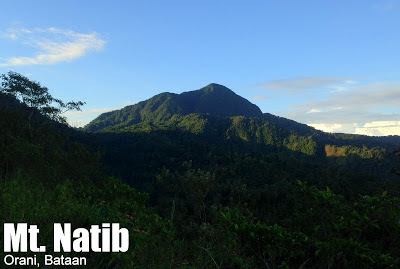
Mt. Natib (1,287+)

.JPG)
MT. NATIB
Orani, Bataan
Major jumpoff: Brgy. Tala, Orani
Minor jumpoff: Kanawan (Hanging Bridge), Morong
LLA: 14.7119 N; 120.3997 E; 1287 MASL
Days required / Hours to summit: 1-2 days / 3.5-5 hours
Specs (Backtrail): Major climb, Difficulty 5/9, Trail class 1-3
Specs (Traverse): Major climb, Difficulty 6/9, Trail class 1-3
Features: Scenic views of Central Luzon; Woodlands; Tropical forests
Article history: Last updated February 25, 2015
BACKGROUND
Mt. Natib in Orani, Bataan is another favorite climb in Bataan, along with Tarak Ridge in Mariveles. It is close enough to Manila, but at the same thing offers a challenging dayhike or overnight climb. The insurgency problem which has hounded hikers long ago is now a thing of the past, and Mt. Natib is fast becoming rediscovered by mountaineers, especially with the emergence of traverse possibilities and attractions such as Pasukulan Falls and Kairukan Falls.
The climb to Mt. Natib is commenced in Barangay Tala in Orani, which is thirty minutes away from the Orani Crossing along the highway. After registering at the outpost in Tala, the trek is started. One hour away is Pinagbutasan; the rough road that serves as trail is spacious and the environments comprise of open grasslands and light woodlands. Past Pinagbutasan, the trail remains wide and comfortable until the base camp is reached.
The base camp lies at the foot of the Mt. Natib, and it is also the bifurcation between the upward assault which leads to the summit, and the seldom-used trail that leads to Mt. Natib’s other attractions: Pasukulan Falls in Abucay and the traverse to Morong. The assault, seen as the highlight of the trek, features steep, forested, rocky, and limaticky trails prior to reaching summit. There are roped segments and the rocks can turn slippery during the rainy season.
At the summit, which is marked a DENR signpost and a small flatland; there are good views of the West Philippine Sea and most of Bataan Province, with Mt. Mariveles on the southwest, with Mt. Samat to its left (SW). To the northwest, on the other hand, stands Subic Bay and behind it, Mts. Cinco Picos and Balingkilat. To the northeast is Arayat, the solitary giant of Central Luzon. Altogether the view is wonderful!
Unfortunately, there is no traverse through the summit, but from the basecamp, one can continue to Pasukuan Falls, which is about two hours away; it is also gaining popularity as a campsite. Moreover, as a really long dayhike or overnight hike, it is possible to trek all the way to Morong, Bataan, through narrow and forested ridges, woodlands featuring majestic and varied forest trees, and finally, a section of Morong River which you have to cross several times before reaching the Aeta village in Kanawan. A hanging bridge serves as the finale for the long trek, and if you are not yet satisfied, you can take the 2-3 hours trek to Kairukan Falls! Clearly the possibilities are growing in Mt. Natib!
ITINERARIES
MT. NATIB REGULAR DAYHIKE
0300 ETD for Orani, Bataan by bus
0500 ETA Orani Crossing. Take trike to Brgy. Tala
0600 ETA jumpoff at Brgy. Tala, Orani Bataan. Register.
0630 Start Trek
0800 ETA Pinagbutasan
0930 Arrival at foot of Mt. Natib; start assault
1100 ETA Mt. Natib summit.
1200 Start descent
1500 Back at Brgy. Tala. Tidy up
1600 Head back to Orani crossing
1630 Take bus back to Manila
1930 Back in Manila
MT. NATIB + PASUKULAN FALLS OVERNIGHT
Day 1
0200 ETD for Orani, Bataan by bus
0400 ETA Orani Crossing. Take trike to Brgy. Tala
0500 ETA jumpoff at Brgy. Tala, Orani Bataan. Register.
0545 Start Trek
0730 ETA Pinagbutasan
0930 Arrival at foot of Mt. Natib (Basecamp).
1200 ETA Mt. Natib summit.
1300 Start descent
1500 Back at Mt. Natib Basecamp. Proceed to Pasukulan Falls
1700 ETA Pasukulan Falls. Set up camp
1830 Dinner / Socials
Day 2
0700 Wake up / Enjoy the waterfalls
0900 Break camp
1000 Head back to Basecamp
1200 ETA Basecamp / Proceed back to Tala
1500 Back at Brgy. Tala. Tidy up
1600 Head back to Orani crossing
1630 Take bus back to Manila
1930 Back in Manila
MT. NATIB + PASUKULAN FALLS – ABUCAY EXIT
Day 1
0200 ETD for Orani, Bataan by bus
0400 ETA Orani Crossing. Take trike to Brgy. Tala
0500 ETA jumpoff at Brgy. Tala, Orani Bataan. Register.
0545 Start Trek
0730 ETA Pinagbutasan
0930 Arrival at foot of Mt. Natib (Basecamp).
1200 ETA Mt. Natib summit.
1300 Start descent
1500 Back at Mt. Natib Basecamp. Proceed to Pasukulan Falls
1700 ETA Pasukulan Falls. Set up camp
1830 Dinner / Socials
Day 2
0700 Wake up / Enjoy the waterfalls
0800 Break camp
0900 Start descent via Abucay
1200 Lunch along the way
1600 Arrival at exit point, Abucay Hacienda / Tidy up
1700 Take tricycle to highway
1800 Take bus back to Manila
2100 ETA Manila
MT. NATIB TRAVERSE TO MORONG DAYHIKE
0200 ETD for Orani, Bataan by bus
0400 ETA Orani Crossing. Take trike to Brgy. Tala
0500 ETA jumpoff at Brgy. Tala, Orani Bataan. Register.
0530 Start Trek
0700 ETA Pinagbutasan
0800 Arrival at foot of Mt. Natib; start assault
0930 ETA Mt. Natib summit.
1000 Start descent
1300 Lunch at Ka Rolly’s place
1500 ETA Morong River crossings
1700 Arrival at Kanawan village. Tidy up near Hanging Bridge
1730 Take trike to SBMA Entrance then jeep to Olongapo
1830 Dinner at Olongapo or Sublic
2000 Take bus back to Manila
2300 Back in Manila
|
Transportation
|
Public (1) Bus, Manila [Pasay, Sampaloc, or Cubao] to Orani Crossing [P187; 2-2.5 hours]
(2) Trike, Orani Crossing to Brgy. Tala [P50/person; 30 minutes] Approximately 3 hours travel time because of various stops and delays. |
|
Registration
|
(1) Logbook at the barangay outpost of Tala.
(2) Hut where Ka Goryo lives P300 registration fee per group plus P5 entrance fee per person as of Feb 8, 2015 |
|
Available; assigned at the tourism office/ barangay hall. No fixed rates but P400/day is suggested (add more if twin dayhikes)
Warning: Guide fees are very expensive in Mt. Natib. Try to negotiate to lower the rates. |
|
|
+639075681785 – Mr. Darwin Ganado, DENR (for guide assignments and reservations)
|
|
|
Campsites and waypoints
|
(1) Mt. Natib basecamp 90 minutes away from summit
|
|
Water sources
|
None past Ka Goryo’s Hut
|
|
Cellphone signal
|
Present in some parts; sporadic at summit
|
|
River crossings
|
None
|
|
Roped segments
|
Yes, but not necessary — just to assist in case the trails get slippery.
|
|
Present
|
|
|
Some
|
|
|
Rattan
|
Some
|
|
Hiking notes
|
The from basecamp to summit can be slippery during the rainy months.
|
|
Sidetrips
|
Kairukan Falls on Morong side of the moutntain
Mt. Samat Nearby mountains include Mt. Marveles and the peaks of Subic |
|
Alternate trails
|
Possible traverse to Pasukulan Falls and to Morong, Bataan (see above)
|
|
Yes, either as a regular dayhike or a traverse
|
|
|
Facilities at jumpoff
|
(+) Sari-sari stores
(+) Wash-up / shower places |
|
800-1000 (dayhike)
1200-1400 (overnight) |
MT. NATIB PICTURES
 |
| The mountains surrounding Subic Bay as viewed from the summit |
 |
| Mt. Arayat as viewed from the trail of Mt. Natib |
 |
| At the summit of Mt. Natib (January 2010)
|
 |
| Grassland before entering the Basecamp and the summit assault (Jan 2010) |
 |
| The same area, over three years later (Aug 2013) |
 |
| Some parts of the summit assault are slippery and steep |
 |
| Crossing a section of the Morong River on a dayhike traverse (Aug 2013) |
 |
| The Hanging Bridge in Kanawan marks the end of the traverse to Morong |
TRIVIA
Mt. Natib is a protected area, part of the Bataan Natural Park, and is one of the mountains featured in the “Our Natural Heritage” coffee table book with George Tapan’s photography. Other mountains featured are Mt. Pulag, Northern Sierra Madre, Mt. Isarog, Mt. Kanlaon, Mts. Iglit-Baco, Mt. Dulang-Dulang, and Mt. Apo.
The blogger’s first atempt to climb Mt. Natib ended up as a failure as we were not allowed by the military to proceed with the hike — this was way back in 2008 (see Hiking matters #12).
MT. NATIB WEATHER FORECAST
PINOYMOUNTAINEER IN MT. NATIB
Hiking matters #12: Natib Negatib
Hiking matters #77: Natib for the first time
Hiking matters #361: Natib Traverse to Morong, Bataan
Leave a Reply
238 Comments on "Mt. Natib (1,287+)"
successfully climb Mt. Natib last May 30. The Pinagbutasan gate is now a viewdeck under the management of the DENR (actually, more of an events venue). Guide fees are the same, expensive but you can always negotiate (I recommend sir Manny who was very helpful and reasonable). Registration fee at DENR is at 30 pesos with student discounts. Limatiks are not very aggressive though it rained all throughout our climb. The rope sections have been well-maintained. A good local guide system is in place (Wilnor apparently is not a member). The trail is open although the local barangay chairperson is against it (due to the honey bee incident).
We tried to conquer the summit yesterday but it is a failure. The wild honey bees were attacked the other group mountaineers. Sir, kontakin nyo po muna ang mga guide sa natib kung pwede na po umakyat.
we had a successful climb here (apr 12-13).
open nmn daw ang natib anytime.
this time meron na cla registration fee na 30 pesos each.
about sa guide, madami tumataga ng presyo. pero i highly recommended Andrew, a 15 year old guy. nakuha nmin cya 900 pesos lng compare kay wilnor na humihingi ng 1,500. nakalimutan ko lng number nya. pero kilala nmn cya dun. just look for him(andrew).
be ready for a technical climb.
thank you.
@kennet hehe dna nmn sir 🙂
open po sya any time ^_^
no registration fee dn,
just register ..
Guys, tanong ko lang kung open na ba ang Mt. Natib? Kailangan pa ba namin ng permit para makaakyat?