
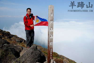
Hiking matters #270: Hiking up Mount Yotei (羊蹄山), the “Mt. Fuji of Hokkaido”


SAPPORO, JAPAN – As the finale in our six-day Hokkaido trip, we decided to accept the challenge of doing the Yoteizan dayhike.Mount Yotei or Yoteizan (羊蹄山) is one of the 100 Famous Mountains in Japan, and is known as the “Mt. Fuji of Hokkaido”, or Ezo-Fuji, owing to its shape and volcanic heritage. At 1898 masl, and with a starting elevation of around 300 masl, the ‘Hiking in Japan’ website gives it a difficulty rating of 4 out of 5.

It is still spring in Hokkaido even though the rest of Japan has already embraced summer. Still, the clouds have become restless in the past couple of days. This is why we were very pleased to see them give way to blue skies as we arrived in Kutchan station (倶知安) coming from the scenic coastal town of Otaru. After buying some snacks and drinks at the train station, we took a taxi to the trailhead, which cost JPY2210.

We started trekking at 0900H. Like every volcano in Japan, Yoteizan has 10 stations (-gome); the trailhead being the first, and the summit the tenth. From the first to fourth stations, the trail pass through a woodland dominated by cedars, and nascent flowers, even as the blooms of summer have yet to emerge.

Gradual at first, the trail became somewhat steeper past the fourth station. Also, pockets of snow revealed themselves, some of which were large enough to necessitate having to trek through them. Fortunately, our snowy Asahi-dake climb the other day (Hiking matters #169) somewhat ‘acclimatized’ ourselves to the mountain conditions. As we ascended up Yoteizan, the views of nearby mountains emerged, including neigboring Annapuri and a distant but splendid Daisetsuzan.

Switchbacks characterized the trails from Station three onwards, with ever receding trees. Save for a Swiss and Japanese pair of hikers, we were the only ones doing the trek, and we encountered a lot of fauna: squirrels, various birds. (Un)fortunately, an encounter with the Hokkaido brown bear did not materialize!

After about four hours of trekking and snow scrambling, we reached the 9th station. From here, the crater rim is within reach; scree slopes ensued — and another walk on snow — and finally, we reached the summit/crater rim. We had still had to go halfway around the rim to appreciate the craters and the stunning views, which included some ‘sea of clouds’.

At this point, we were very cautious as Yoteizan is notorious for bad weather, particularly at the summit area, where fierce winds and rains can suddenly arrive. Fierce winds did arrive, but only when we were already descending. If these winds had come thirty minutes earlier, we would have been forced to abort the climb. We were truly blessed with great weather throughout our Hokkaido trip!

After having lunch on the first high point, we headed for the summit, arriving at 1430H. We stayed for 30 minutes, just as the clouds began to roll in. The descend was much faster. Halfway along the trail, I phoned the number that the taxi driver had given me earlier, just in case we wanted a ride back. Yes we did! And at exactly 1800H, the time I had set, the taxi driver was waiting! “Yokatta, kyo no tenki wa ii da!” I gleefully told him when he inquired about our climb.

So now, back in Sapporo and waiting for the Hamanasu Express train to Aomori, I am about to leave Hokkaido very happy with the hikes that we did. I will come back to this island of great outdoors, deicious food, and very nice people. The Daisetsuzan Grand Traverse, Rishiri and Rebun, and the Shiretoko Peninsula are waiting!

TWO HIKES IN HOKKAIDO (北海道) JAPAN
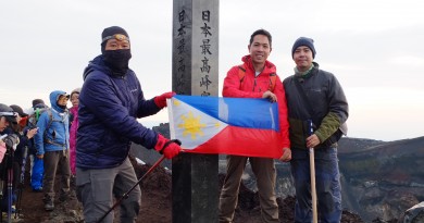
Hiking matters #269: Asahi-dake – Daisetsuzan 旭岳 (2290m)
Hiking matters #270: Mount Yotei 羊蹄山 (1898m)
Leave a Reply
Be the First to Comment!