

Mt. Palali (1,715+)

 MT. PALALI
Quezon, Nueva Vizcaya
Jump-off point: Purok 5, Brgy. Maddiangat, Quezon
LLA: 16.4283°N; 121.2236°E; 1,715 MASL
Days required / Hours to summit: 2 days / 6-8 hours
Specs: Major Climb, Difficulty 5/9, Trail class 2-3
BACKGROUND
A little-known but very beautiful destination in Northern Luzon is Mt. Palali in Nueva Vizcaya. Once the hunting ground of the Bugkalots, Gaddangs, and Ifugaos, this majestic mountain offers a commanding view of the low-lying municipalities of the province.
 The jump-off point is accessible through tricycles or jeeps less than 30 minutes from Solano. Getting guides, however, seem to be quite a challenge but the risk of going there without prior arrangement is a fair-enough risk, as Mt. Palali gets more and more popular as a climbing destination. The trail begins as a rough road, as in many mountains, and it gives way to a beautiful forest. This forest has recently been declared as a ‘protected area’ and should be respected as such. There are many avian species; indeed the forest is the closest most of us can get to the deep jungles of Palanan, farther east.
Several hours into the climb, huge boulders will appear, heralding the end of the first half of the trek. Afterwards, the landmark known as Haring Bato will be reached – the halfway point. Another account says this area is in the native tongue known as Dinar-awan. Here, and when the forest occasionally gives way to the cogon grassland which is the usual environment of Philippine peaks, the view is like that of Mt. Arayat: instead of Pampanga River, there is Magat River, sweeping across the plains as it commences from Vizcaya; and looming in the west are mountains such as Mt. Ugo, the saddle of Ambaguio, and on a clear day, Mt. Pulag itself, and northward, Mt. Napulauan, and a distant Mt. Amuyao. Meanwhile, equally alluring are the mountains of the east side: the Sierra Madre range, with its rarely-explored environs.
The summit, again like its Arayat and Makiling counterparts, is forested. Take time to observe the fauna and flora there – pitcher plants, creepers, and wild flowers create a Jurassic aura that caps off the climb to one of the more pristine places in the country.
ITINERARY
2200 Assembly at Victory Liner Kamias Terminal along EDSA
2300 ETD to Solano, Nueva Viscaya
Day 1
0500 ETA Solano, Nueva Viscaya. Breakfast.
0630 Take trike/jeep to Purok 3, Brgy. Maddiangat, Quezon
0700 ETA Purok 3 / Final preparation / Arrange local guides.
0800 Start Trek (6-8hrs)
1200 Lunch along the trail (Packed Lunch)
1300 Resume trek
1400 Grand view deck (Haring Bato 1435 MASL)
1500 ETA Camp 2
Day 2
0500 Wake-up call / Breakfast
0700 Commence summit assault.
0800 ETA Summit of Mt.Palali (1715MASL).
0830 Back to Campsite.
0930 Break camp
1000 Start descent.
1200 Lunch along the trail.
1300 Resume trek.
1600 Brgy. Maddiangat / Tidy up
1630 ETD to Solano.
1700 Solano
1800 ETD to Manila.
0000 ETA Manila.
SPECIAL CONCERNS
Camping notes. There are a couple of water sources before Haring Bato, and there is also a water source at Camp 2, which is the major campsite. Although large groups have camped up Palali, the campsites are quite small, comfortable for only a few tents. Cellphone signal is present at the summit and at the initial leg of the trail, but very weak at Camp 2.
MT. PALALI PICTURES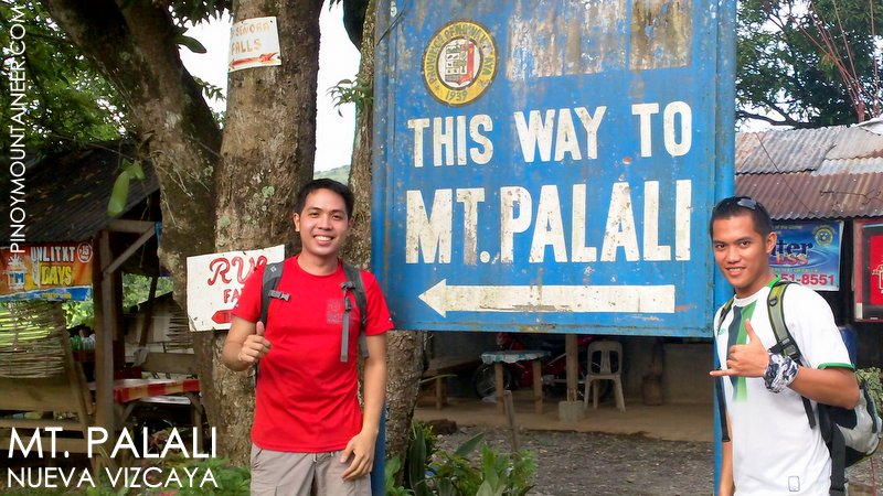


It is interesting to note the following entry in this page before we launched the 9-point Difficulty Scale in 2009, an initial attempt to make a more precise scaling:
This climb can be done as an extended dayhike – a dayhike requiring a fast pace and around 5 hours of trekking to reach the summit. The blogger did such a dayhike on July 10, 2012 with travel blogger Journeying James. An account of this hike is narrated in Hiking matters #281.
PinoyMountaineer.com thanks Vanessa Lacson of the OLAY Mountaineers for supplying the information and photos for the original version of this article.
Leave a Reply
27 Comments on "Mt. Palali (1,715+)"
http://www.youtube.com/watch?v=bnjnrff1CNc
eto po yung ginawang documentary ng climb namin june 2011… 🙂
May Limatik out break po b dto ?
Lagi ko tong nakikita dati nung bata pa ako pag nagbabakasyon kami sa Bayombong. Tapos biglang napanaginipan ko kagabi na may bundok akong inakyat na 1700+ MASL, no doubt eto nga yon. 🙂 Hope to climb Palali soon.
if given a chance, either july 28 or august 4, akyat kame jan…hahaha…mahabang lakaran pala yan….kayanin kaya namin to, since puro mga baguhan yung mga makakasama ko…hehehe…
Kung sinoman pong grupo ang aakyat sa Mt Palali, Mt Napulauan at Mt Ugo, pajoin naman mga Sir, amateur po ako pero kaya ko hindi po active mga grupo ng Mountaineers dito. Dito lang po ako sa Solano, Nueva Vizcaya.. 09175931491