
Mt. Pulag Ambangeg Trail (2,922+)


MT. PULAG (AMBANGEG TRAIL)
Bokod, Benguet
LLA: 16°34’58″N 120°53’15″E, 2922 MASL (#3)
Days required / Hours to summit: 4-5 hours / 1-2 days
Specs: Major Climb, Difficulty 3/9, Trail class 1-2
Trail system: Grand Cordillera Trail, Section 3
Features: Sea of clouds, dwarf bamboo slopes, pine forests
Last updated: December 3, 2015
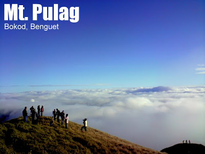
Majestic Mt. Pulag is highest peak in Luzon and one of the most beautiful mountains in the Philippines. Its fabled views, of winding slopes of dwarf bamboo, and distant peaks surging like islets in the ocean of lofty clouds, comprise perhaps the most breathtaking sights in Philippine mountaineering. The native tribes say that Mt. Pulag is the “playground of the gods”. In Luzon, it is literally the closest to heaven that mountaineers can get!
 The map illustrates the approximate locations of each trail, as well as its path, in relation with the summit of Mt. Pulag. The Ambangeg Trail is discussed in this main article. Visit also the Akiki Trail and the Tawangan Trail.
THE AMBANGEG TRAIL
It is very convenient to make arrangements for jeepneys from Baguio to take you directly to the Badabak Ranger Station. This significantly cuts climbing time, and it makes possible a 2-day Pulag climb. If you arrive early in the morning in Baguio, you can take the jeep and be at the Ranger Station by lunchtime.
 From the Ranger Station to the summit is around 8 kms. First you will pass by wide trails, surrounded by pine trees and picturesque landscape. After awhile, you will enter the montane forest, with its grand spectrum of flora – from the pink flowers known locally as ayusep (see photo) and various mosses to the archaic, bonsai-shaped trees. The next landmark in the middle of the mossy forest is Camp 1, marked by a hut.
In the entirety of the trek to the grassland, there’s only one moderately steep part, taking just a few hundred steps. Actually the trail is very relaxing and enjoyable, with the cool weather and the encounter of various faces of the mountain (pine trees, montane forest, grassland). At the montane forest, you will catch the first glimpse of the Pulag summit, which has a hue of golden brown.
There are a few campsites to choose from: Camp 1 is still within the mossy forest area; in Camp 2 the grassland is just beginning (2600+ MASL). There is also another campsite which goes beyond the summit, on the way to the Akiki trail. This is the saddle campsite (Camp 3) and is preferred by those who want close proximity to the summit. Camp 2 is the most advisable campsite, with a close water source, latrines, nice views, and more manageable weather conditions. However, the saddle campsite, being very the near the summit, takes you as close to the sky as possible. Either way, brace yourself! Temperatures can really plummet to near-freezing levels.
Ranger Station to Campsite 2 takes around 3 hours. From this camp, the summit assault is typically done either late afternoon (for the sunset) and very early morning (for the sunrise). The trail beyond this point is offers unparalleled grassland landscapes, with the grand array of the Cordillera mountains as backdrop. The dwarf bamboo grass that envelope the slopes is a wondrous presence. After an hour of trekking, you will finally reach the summit, that is, the highest point in Luzon.
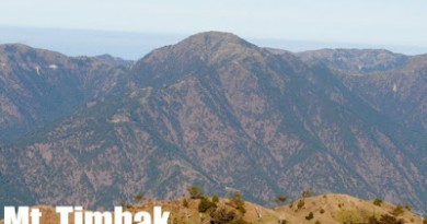
 The summit views of Pulag are fabled and legendary. On a blessed time, seas of clouds form beneath, covering everything but the highest points in the Cordilleras: Mt. Amuyao rises very distinctly northeast, then the twin Mts. Kapiligan and Napulauan (NNE). The picture on the left shows the blogger’s hands at Amuyao (L) and Napulauan (R). Mt. Tabayoc (N) and Pulag is separated by Mt. Panotoan (N). Then moving your eyes westward, you will see the the mountains of Tenglawan and Kibungan (NW), and you will also appreciate Mt. Timbak (WNW), said to be the Luzon’s third highest point. The range from which Mt. Timbak rises is one where the Halsema highroad, the Philippines’ highest highway, passes. In this range one can also see Mt. Pawoi (W). Beyond this, further west, is already the Ilocos region. Baguio City and Mt. Sto. Tomas continue the visual circle (WSW) and if the sea of clouds is lower than 2100 MASL, you can also see Mt. Ugu (S). These are objective sights to see, but the subjective feeling of being there, above the clouds, is hard to put in words. How beautiful exactly? One has to go to Pulag in order to find out.
MT. PULAG VIA AMBANGEG ITINERARY
Note: It is also possible to take regular public transport to the Visitors’ Center but it will be difficult to manage a two-day itinerary since the bus would arrive in the afternoon and this would still necessitate taking a motorcycle to the Ranger Station. However, this is very possible with a three-day itinerary.
Day 0
2300 Take bus to Baguio City
Day 1
0500 ETA Baguio City. Breakfast then proceed to jeepney terminal/chartered jeep.
0700 Take chartered jeepney to Ambangeg.
1000 ETA Visitors’ Center. Registration / Orientation
1130 Set out for Ranger Station
1230 ETA and lunch at Ranger.
1300 Start trek
1430 ETA Camp 1
1600 ETA Camp 2. Set up camp
1800 Dinner at campsite; socials
Day 2
0430 Early morning trek to summit for sunrise
0545 Arrival at summit just in time for sunrise
0700 Start descent from summit
0800 Back at Camp 2; heavy breakfast
0900 Decamp; start descent to Ranger Station
1130 Back at Ranger; Settle guide fees; jeepney descent
1230 Back at Visitors’ Center; tidy up and log out
1400 Head back to Baguio City
1700 ETA Baguio City. Dinner.
1900 Head back to Manila
0200 Back in Manila
|
General
Disclaimer
|
Please read the Terms of Use for using information in this website.
|
|
Transportation
|
Public (1) Bus, Cubao or Pasay to Baguio City [P460, 6-7 hours]
(2) Rented jeep to Ranger Station [P8000 for up to 18 persons, 3-4 hours] or public bus in Dangwa, Baguio City i.e. A-Liner [P120/person, 4-5 hours] then habal-habal to Ranger Stn.
Private: NLEX>SCTEX>TPLEX>Marcos Highway or Kennon Road>Baguio City then take road to Kabayan via Itogon. For 4×4 vehicles it may be possible to take vehicle up to Ranger Station but sometimes road conditions make the Visitors Center inaccessible. Check with DENR first.
|
|
Registration and scheduling
|
Mandatory orientation and registration at the Visitor’s Center, total fees P225/person.
Note: as of December 2015 medical certificates are also required. Visit this link for a sample medical certificate that you can ask your physician to fill out. Note 2: Due to the mountain’s popularity there have been reports of the mountain being “fully booked”, which is affecting individual hikers and groups. It is advised to contact the PASU as soon as possible or avoid weekends or peak season (i.e. Holy Week)
|
|
Guides are secured at the Ranger Station; a system is in place and no prior communication is required. The rate is P500/guide for 1-5 persons, and P100 for each addition person thereafter. The maximum number of persons/guide is 10 (P1000) but with 11 persons, the cost is just (P1100). Porters may also be secured at P300/day.
|
|
|
DENR-PASU (Mereng) – 09196315402
Note: The DENR-PASU has requested PinoyMountaineer not to post numbers of transportation contacts that are not accredited with them. Disclaimer: contact numbers are listed for information purposes only and does not constitute an endorsement of any services. |
|
|
Campsites
|
Grassland campsite (Camp II) and Saddle campsite (Camp III)
|
|
Water sources
|
About 100 meters from Camp II; none in Camp III
|
|
Cellphone signal
|
May be weak in Camp II, sporadic but present in summit
|
|
River crossings
|
None
|
|
Roped segments
|
None
|
|
None
|
|
|
None
|
|
|
Rattan
|
None
|
|
Hiking notes
|
The temperature in Mt. Pulag can reach zero or subzero levels especially from December to February; hikers should be prepared for cold weather throughout the year.
|
|
Sidetrips
|
Mt. Tabayoc and the Four Lakes in the far side of the park, other Cordillera peaks.
|
|
Alternate trails
|
|
|
Theoretically yes (3-5 hours to summit; 2-3 hours down) but logistically difficult if coming from Baguio.
|
|
|
DIY 2000-3000
Guided tours 3800 and up Note: For more information about small groups and solo hikes to Mt. Pulag, visit the Mt. Pulag Do-It-Yourself Guide in PinoyMountaineer |
ADDITIONAL NOTES
Environmental concerns. There are growing concerns about the sustainability of the ecotourism activities in Mt. Pulag, with many pointing out that the current influx of weekend hikers exceed the carrying capacity of the mountain. To reduce impact on Mt. Pulag, PinoyMountaineer suggests avoiding camping in the weekends or peak seasons such as the Holy Week, or minimizing group number to 15 or fewer (with 30 as upper limit). This suggestion is also for the hikers’ sake: you may not enjoy a campsite full of people. For serious hikers, the less-trodden Akiki, Tawangan, Ambaguio trail, or the Ugo-Pulag Traverse (as part of the proposed Grand Cordillera Trail) may be more rewarding encounters with the outdoors. Moreover, PinoyMountaineer does not advice would-be visitors of Mt. Pulag to patronize organizers who do not regulate their number of participants.
MT. PULAG WEATHER FORECAST
MT. PULAG TRAILS AND ITINERARIES
Ambangeg | Akiki | Tawangan | Ambaguio | Ugo-Pulag (Kayapa) | Luzon 3-2-1

Leave a Reply
357 Comments on "Mt. Pulag Ambangeg Trail (2,922+)"
Kung may akyat ng Pulag this coming weekend June 14 kung pwede sabay po ako sa jeep nyo. Solo lang ako. 09178170173. Thanks
Hi. Baka po meron mag Pulag this coming weekend June 14 at pwede makisabay ako sa Jeep nyo. solo lang po ako. 09178170173. Thanks
Hello po may climb po kami sa Mt. Pulag on the said dates may30-june 1 via ambangeg-ambangeg trail. We need at least 10 more participants para po makahati sa renta ng jeep. Text niyo lang po ako kung interesado po kayo 09158895253
mga sir bka po meron interested sumabay samin sa pulag june 6-8 akiki-ambangeg trail june 5 ng 11pm po alis,pra po my kahati sa rent ng jeep txt nyo lng po aq 09437257815 tnx
-gel
our group Fun Cycling Club (FCC) of San Fernando City, La Union just climbed Mount Pulag summit yesterday
April 5, 2014