
Mt. Gulugod-Baboy (525+)

 MT. GULUGOD-BABOY
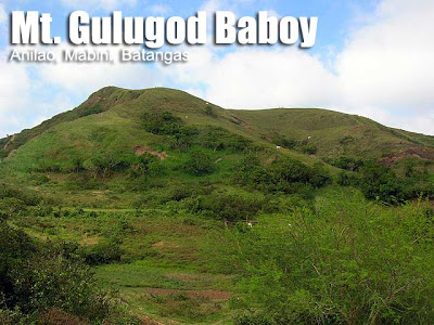
Anilao, Mabini, Batangas
Jump-off point: Philpan Dive Resort, Anilao, Mabini
LLA: 13°42’55″N; 120°53’43″E; 525 MASL
Days required / Hours to summit: Half-day / 1-2 hours
Specs: Minor climb, Difficulty 2/9, Trail class 1-2
Features: Scenic views of Batangas Bay and Balayan Bay
BACKGROUND
Gulugod-Baboy is the general term that describes the hills that traverse Calumpan Peninsula in Mabini, Batangas. Located in Southern Batangas, the peninsula is more known for the diving resorts of Anilao – the birthplace of Philippine scuba diving. Since dive enthusiasts are also enthusiasts for anything ‘outdoor’, they began exploring the hills, and soon, Gulugod Baboy became a hiking destination on its right, although today it remains a popular sidetrip to a diving escapade to Anilao, or to the nearby Sombrero or Maricaban islands.
There is confusion regarding where the real “Gulugod-Baboy” is. From SE to NW (from Brgy. San Teodoro to Brgy. Laurel), there are three peaks in the range. The first is 470 MASL, the second is 485 MASL, and the third is 525 MASL. This third has a large, ancient tree as its landmark, and is known to mountaineers as the real Gulugod Baboy. However, locals say that this third peak is actually Mt. Pinagbanderahan, and the first peak is the Gulugod Baboy. Fans of Long Henson, father of itineraries, would remember that he wrote about a Mt. Pinagbanderahan in Mabini, Quezon. This may actually refer to Mabini, Batangas, and is actually one and the same as the Gulugod-Baboy we know. Thus, there are three peaks, from SE to NW: Gulugod-Baboy, Gitna, and Pinagbanderahan.
Gulugod-Baboy is a playground for adventure: you can refer to the map and ascend/descend to any point in the peninsula using the compass. Most directions have trails; indeed there are many trails in the mountain which is both an advantage and a disadvantage. At its peaks, you can see, from east to west: Janao Bay, Maricaban strait which bears Sombrero and Maricaban islands, a distant, faint blue Mindoro, Verde Island (SW) and Batangas Bay. The city and port of Batangas is visible on the east, and behind and beside them, the mountains of Lobo, the nearest one being Mt. Pinamucan (E). To the northeast is Mt. Maculot, and even Mt. Batulao and the Tagaytay highlands (NW).
ITINERARY
0500 ETD Manila via private vehicle^
0800 ETA Brgy. San Teodoro or Philpan dive resort Anilao
0830 Start trek
1000 ETA Gulugod-Baboy (Peak 1)
1040 ETA Gitna (Peak 2)
1130 ETA Pinagbanderahan (Peak 3). Lunch
1200 Descent via Brgy. Laurel
1300 ETA Brgy. Laurel, Mabini. Take jeep to town proper
1330 ETA Mabini town proper; take jeep to Batangas City or van to Manila
^ an option is to take bus to Batangas City (P150), then charter a jeep to Anilao.
SPECIAL CONCERNS
Plan ahead if you’re going to do a traverse, or head back to Anilao and stay in the dive resorts there. Gulugod-Baboy is one hike trip in which private transportation is advised. As you trek through Gulugod-Baboy you will be passing by private property; make sure you observe proper courtesy. Also, there are dogs on the loose in some parts so be careful.
MT. GULUGOD-BABOY PICTURES
 |
| Though the Philpan Dive Resort is the usual jumpoff, there are many starting-off points in the peninsula |
 |
| The scenic views of the Balayan and Batangas bays can be enjoyed even at the start of the trail. |
 |
| View of Batangas Bay from one of the peaks of Mt. Gulugod-Baboy |
 |
| Gulugod Baboy’s first peak, 470 MASL |
 |
| View of Verde Island passage with Maricaban island (L) and the tiny Sombrero island, shaped like a hat. (R) |
 |
| The famous tree near the summit of Mt. Gulugod-Baboy. |
TRIVIA
Gulugod-Baboy means “pig’s spine”, so named because of the contours of the hills. “Gulod”, however, means hill; “pig’s hill” can also depict the pastoral scene of the mountain. You would normal encounter cows, goats, and in the past, pigs, as you trek through the mountain.
For its part, Pinagbanderahan has a historical background. It can be translated, “Where the flag was hoisted”, and it commemorates the crash landing of the Japanese in early 1942. In the heat of World War II, Japanese airmen had a mishap and crash landed in the slopes of Gulugod-Baboy. To celebrate their survival, they planted a flag in the summit. Since then, locals called it “Pinagbanderahan”.
RELATED POSTS
Hiking matters #30: An escape to Anilao and Gulugod Baboy
WEATHER OUTLOOK: ANILAO, BATANGAS
Leave a Reply
260 Comments on "Mt. Gulugod-Baboy (525+)"
bigyan nyo po kami ng idea s mt.gb. may malapit po b n water source s peak. need po b nmin ng guide pag akyat nmin. thank u po
sir p advice po plano naming umakyat ng aug. 29-30, 2015.
bigyan nyo po kami ng idea. lhat po ako n aakyat first time lng s mt. gulogod baboy. may malapit po bang water source dun s peak. pwede po b kami dun mag overnight s peak. need po b namin ng guide dun. thank you
Hi po. We have scheduled climb po in Mt. Gulugod this coming May 10, Sunday. After climb we're planning to go on swimming sa philpan resort. What's the best jumpoff site we must take to descent in philpan. Thank you po sa help.
Hi po! We have schedule climb po this coming May 10. Our group po will go on swimming after the climb sa philpan. What's the best jump-off site po should we take para descent po nmin philpan na?
Salamat po sa help.
nakainggit kayo, nagkocompla kayo ng intense heat ng sun ibig sabihin clear day. When we ascend 4pm just last Sat we encountered the fog when we reached the third hut and it did not gave us a clear spot at all up to the summit. Pitching tent while "raining". In the morning it was still fog but it thickened 9am to 1pm up to the 2nd hutproviding halo halo going down.
May issue pa po ba sa registration dito? Or any other problem? Thanks