
Mt. Kalisungan (760+)

 MT. KALISUNGAN
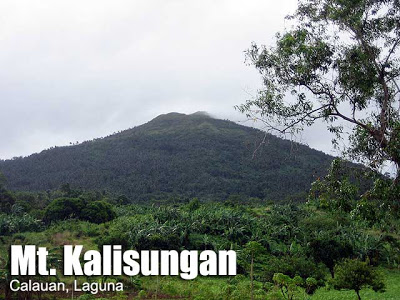
Calauan, Laguna
Jump-off point: Brgy. Lamot 2, Calauan
LLA: 14° 08.790N; 121° 20.683E; 760 MASL
Days required / Hours to summit: 1 day / 2.5-3 hours
Specs: Minor climb, Difficulty 3/9, Trail class 1-2
Article history: Created 8/14/07, last updated 02/20/14BACKGROUND
Mt. Kalisungan In Calauan, Laguna is one of the smaller mountains in the Southern Tagalog region, but is nonetheless prominent because in many points of view, it is one of the mountains that flank the Banahaw Trilogy. Moreover, it has a special place in history as the final stand of the retreating Japanese soldiers in Laguna towards the end of World War II (1945-1946). It used to be – and still is – a mountain that has many names. Some call it Mt. Calauan or Mt. Nagcarlan after the two towns it borders; others call it Mt. Lamot because it lies in Brgy. Lamot. There is growing consensus, however, that this mountain, rising to 760 MASL, should be known as Mt. Kalisungan.Japanese guerrillas at the twilight of World War II made Mt. Kalisungan their last stand in Laguna. Afterwards, locals erected a white cross at its peak. It has become a local Holy Week custom to climb the mountain. Throughout the year, Mt. Kalisungan receives ample rainfall, and because of its relatively rustic location, its great charm lies in its serenity. Fruit trees – from rambutan to kaimito, and of course buko – provide trail food year round, as well, but don’t forget to ask permission before picking!Verdant fields surround the slopes of Kalisungan. There are coconut trees, banana plantations, corn fields, citrus orchards, and vast grasslands leading to the summit. As one goes higher, the view becomes more distinct: directly in front of you, to the north, is Talim island with its Mt. Tagapo shaped like a young woman’s breast; you can also see Jalajala peninsula jutting into Laguna Lake like a ship, with Mt. Sembrano on its helm. Moving your eyes to east, the highlands of Caliraya appear. And once you reach the peak, you will be able to glimpse upon the seven lakes of San Pablo, flanked by Mt. Cristobal and Mt. Banahaw. Then, from a distance there is Mt. Makiling, to the west, completing the circle.
ITINERARY
0600 Board Green Star bus bound to Sta. Cruz from LRT-Buendia (P117)
0830 Alight at Victoria, Laguna (at the Duck junction). Take tricycle to Brgy. Lumot
0900 ETA Brgy. Lamot. Ask for the way up. Register at Brgy. Hall.
0915 Start trek
1200 ETA summit. It is marked with a white cross. Lunch.
1300 Start descent
1530 Back at Brgy. Lamot. Take tricycle to Victoria, Laguna
1600 Wait for Buendia or Cubao-bound buses at highway
1900 ETA Manila
PRACTICALITIES: MT. KALISUNGAN
|
Transportation
|
Public
(1) Bus, Cubao or Buendia to Victoria junction [P120, 2.5 hours] (2) Tricycle to Brgy. Lamot 2 barangay hall and optionally, a kilometre or so in the cement road in the initial leg [50/trip; 10 minutes] Private (1) Head to Calamba via SLEX; (2) Follow through the national highway passing through Pansol and Los Banos until you each junction of Victoria. (3) Make a right turn at junction and go straight until you reach Brgy. Lamot 2 barangay hall; parking is available [2 hours] |
|
Registration
|
Logbook at the barangay hall. [Note: As of 2016-17, there are reports of conflict between certain guides and local officials. PinoyMountaineer does not take sides in local disputes]
|
|
Available; 400/day
|
|
|
Campsites
|
At the base of the summit and at the summit itself
|
|
Water sources
|
None in normal course of trail
|
|
Cellphone signal
|
Present throughout the trail
|
|
River crossings
|
None
|
|
Roped segments
|
None
|
|
None
|
|
|
None
|
|
|
Rattan
|
None
|
|
Hiking notes
|
Caution when ascending the steep portion before the summit; there may be loose rocks. The blades of the talahib can cause ‘papercuts’.
|
|
Sidetrips
|
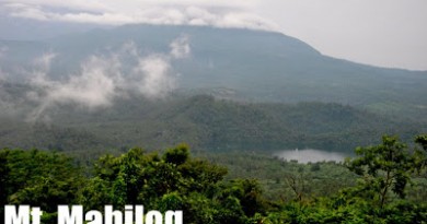
Bunga Falls and Underground Cemetery in Nagcarlan; Mt. Mabilog
|
|
Alternate trails
|
There is a traverse to Mt. Atimla but there are security concerns so it is best to ask the guide or locals if it’s okay to continue. See description of this traverse in Hiking matters #339.
|
|
Yes (2-3.5 hours to summit; 1.5-2.5 hours down)
|
|
|
600-900
|
MT. KALISUNGAN PICTURES

At the foothills, the trail is wide and surrounded by beautiful trees and plantation fields (2007).

Midway, you will encounter some dense foliage comprised of grasses, shrubs, and banana trees.

Along the trail with Ms. Agot Isidro and Coby Sarreal (Jan 2013)

The summit is meadowy and verdant: the winds are quite refreshing (2007).

A wooden cross used to mark the summit; it has since been replaced by a cement one (2007).

One of the best views at the peak is that of San Pablo’s Seven Lakes – at least six of which are visible at the peak. In this picture, the lakes seen are Mohicap, Palakpakin, and Sampaloc (2007).

Aerial view of Mt. Kalisungan (lower right) shows its grassland peak, Mt. Atimla beside it, and the San Pablo’s Seven Lakes (2011).
Jan 2007 (before PinoyMountaineer.com)
Jan 2011 Hiking matters #118: First climb of the year
Sep 2012 Hiking matters #287: Kalisungan revisited
Dec 2012 Hiking matters #314: Kalisungan and Mabilog
Jan 2013 Hiking matters #319: First climb of the year again
Leave a Reply
206 Comments on "Mt. Kalisungan (760+)"
I will never forget my experience in Mt. Kalisungan grabe. Eto ang first mountain ko, nung first climb ko is feb 1, 2015 hindi pa ako handa nun kala ko kasi easy trail lang sanay kc ako sa trails in Mt. Makiling because im from Los Banos. Kasama ko friends ko we were 4 that time. Naligaw pa kame kc sinusundan namin yung kabayo ni kuya na kasabay nain umakyat un pala papunta yun sa kubo nya kaya umikot pa kame sa kagubatan at damuhan. Nung nasa summit na kame grabe sobrang ganda at sobrang lamig. Parang paradise. Grabe tlga hindi ko makakalimutan yun. Nung second hike namin is April naman the same year (naadik na kame sa ganda) overnight na yun nagsimula kame ng 12pm grabe sobrang init pati hangin mainit dun sa baba ng bundok. Yung supposedly 3hours hike namin naging 5hours dahil sa init tapos naligaw pa kamendumaan kame sa madamig damo na madaming tinik sa punuan grabe parang naging level 5 yung hike namin tapos nung nakita ko yung trail ansaya ko haha. Angganda sa tuktok pa gabi kitang kita mo yung lights sa baba so amazing tapos yung stars sa taas don ko nakita ang 1st shooting star ko. Anlamig pa it's like 10 degrees pababa ang lamig mahamog pa which im not expecting it to be kasi summer nga. Hinding hindi ko makakalimutang ang experience ko sa Mt. Kalisungan, my first mountain hike that i reached the summit. Sa tingin ko magiging hiker na ako and i would be so happy if ever i became one. Im just 18 and i will climb mountains here in the Philippines. Totoo nga nakakaadik ang hiking. Jj from LB.
may security concern parin po ba dito, Holdaper sa trail, or yung nangugulo na residente sa baba ng trail, planning kasi kaming umakyat sa holly week, and pwede po ba mag traverse ng atimla salamat po sa sasagot.
mark of muntinlupa
Hi pinoy mountaineer! Galing kaming kalisungan last week. May bago nang trail, ginawa siya nung kinuha naming guide (ate mercy). Wala na rin po yung cross sa peak, sabi ni ate mercy eh ninakaw daw ng mga taga roon. Yung new trail po eh assault mula sa baba hanggang peak, may nakakalito lang pong fork na pag mali ang nadaanan mo, mapupunta ka sa baba, nakalimutan ko kasi yung lugar pero pababa po yung isang daan.
Hi…
Just to give you an update.
As of this writing, the kalisungan – atimla trail is closed due to fallen trees brought by typhoon Glenda. As per Mang Bino, the trail is not yet accessible.
So instead of kalisungan – atimla, we did a kalisungan – mabilog twin dayhike. We started trekking at 6:30 am, our guide is ate mercy, wife of mang bino. We used the new trail, near the covered court. Almost all part of the trail is considered assault, pero masaya, kasi tutulo ng husto pawis mo. Dahil na rin sa bagyong Glenda, midway ng hike, very visible na yung neighboring mountains such as makiling, maculot, malinpuyo range, talim island, mt. sembrano, and even taal. Compared kasi dati, takip ng mga puno yung view. We reached the summit at 8:30 am.
Sa mga, gusting umakyat sa kalisungan. I suggest na dun muna kayo sa new trail then pagbaba, dun kayo dumaan sa old trail which leads to field of faith.
P.S. Thanks sa lucban ate mercy! 🙂 sabi mo nga, pag natikman mo, babalik ka sa sarap. hehe.
Happy Morning Pinoy Mountaineers…
We just climb Mt. Kalisungan yesterday (January 31, 2015) via its new trail with Kuya Bino as our guide. We started trekking by 8:30 am and reached the summit at 10:30 am (medyo sagana na kami sa pahinga kasi puro paakyat yung trail). We stayed for one and a half hours at the summit (solo namin ang taas kasi nakababa na ang first batch na umakyat and according to Kuya Bino, they will do a twin hike sa Mt Mabilog which you can view from the summit). We descended for less than an hour only and nakabalik kami ng Manila at 4:30 pm.
Walang problema sa bagong trail, no "limatik" and the like. Wala na rin yung wooden cross sa summit.
At the summit, you can see the picturesque of neighboring mountains in Laguna, Batangas, and Rizal. And of course the seven lakes of San Pablo.
The guide rate is still fixed at P400 for dayhike.
Happy Trekking…