
Classifying Philippine mountains: Is Level I, II, III a valid measure?

By Long Henson
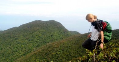
Mountaineers are fond to use “Levels” to describe the difficulty of the mountains. When an unfamiliar mountain is mentioned in a conversation, the first question commonly asked is, “What level?”
However, it was soon realized that this classification is quite subjective. Pulag is supposed to be Level III, but how come the Ambangeg Trail is just like a Mt. Makiling climb and Akiki Trail is so difficult? Indeed, the levels are unable to describe the nature of the climb itself. To say that 1000 MASL and below is level I; 1000-2000 MASL is Level II, and 2000 above is Level III is likewise erroneous. Baguio City is 1500 MASL, but you don’t have to climb to go there.
To address these, Pinoy Mountaineer turns to Long Henson, who mapped out much of the mountaineering scene thanks to his web itineraries, for answers. Here are excerpts from his response:
[Classifying the mountains under Level I-III] is actually a practice by early mountaineers. But it’s really subjective and I think it’s no longer relevant. I think the levels were initially based on height. But to make it relevant, they considered difficulty as well as distance (i.e. multi day hikes on low level mountains), all the more made it more subjective. And of course difficulty depends on each person. The levels were defined by early climbers and were accepted by later climbers who got a hold of the information that this mountain is categorized as such. So each climber to a new destination would declare it by himself and others would follow.
By the way, during the early mountaineering days, there were two local classifications accepted: the Minor-Major classification (which is more widely used) and this leveling system (Levels 1 to 3).
I think to correct this, either we start using international standards or umbrella groups such as MFPI should create committees amongst its group to do official ratings (which is actually the beginning of all acceptable standards like Yosemite System being used now on rock climbing i.e. 5.1, 5.2, etc.).
Here is a more detailed explanation of the two-tier system:
1. Minor Climb – a climbs that can be done on one day
2. Major Climb – a climb that requires an overnight stay
(others jokingly add: minor climb = minor gastos; and major climb = needs major budget)
That is the basic criteria. There is actually no defined height criteria but we can say that a minor may be 1,000-1,500 MASL and major are beyond that. But as mentioned, difficulty is not defined by height. It’s also not connected to the destination. For instance, Mt. Romelo (Famy) is a minor climb. But you can make it a major if you use a more difficult route or if you explore other portions or even sarcastically climb the same trail x number of times. So if we would correct this classification system definition, the classification should describe the activity you are planning and is independent on the destination or mountain (maybe the route you are taking). You can say I’ll climb Makiling and the climb would be Level 1 or I will climb Makiling but the climb I’m planning is Level 2.
For the Level classification, it further confused the system by putting three subjective levels as Level 1 (below 1000), Level 2 (1000-2000) and Level 3 (2000 beyond).
Here is more accepted international rating system:
Class System
1 – Walking (easy stroll)
2 – Hiking along a path/rugged terrain
3 – Scrambling (using hands for balance)
4 – Climbing easy cliffs but with enough drop off- beginners should be roped.
5 – Using free hands as climbing method
6 – very difficult and need to use artificial method
Another system is Commitment Rating (which as I described above for our local Minor-Major system) rates the “commitment” rating of the climb i.e. I – few hours, II – half day, III – full day, IV – overnight, V – 1 and a half to two days, VI – 2 days and VII – extreme multi day ascent. Still there is this open classification for more than 2 days. So a 3 day to a 100 day is still classified as level VII.
Many thanks to Long Henson of the Metropolitan Mountaineering Society for sharing his thoughts on this topic. Since November 2007, PinoyMountaineer.com has begun developing a rating system that uses Major/Minor system; the Trail classes, and the Relative Difficulty scale.

Leave a Reply
9 Comments on "Classifying Philippine mountains: Is Level I, II, III a valid measure?"
How about featuring other climbers' INTERNATIONAL climbs (with photos) so that others may LEARN from them in general . . .
Long, congratulations…. MMS owes you a lot… I know that that is what you dreamed for the organization…. your passion for mountaineering has helped a lot of people get to know and love the mountains…. thank you for making it big for MMS…. Thank you for the success it is now enjoying.
sir nats, thank you for sharing to us this mt. patukan…i saw the youtube..this sounds like a very very interesting and challenging mountain! where can i contact you to get more info? thanks!
nice post, we have ideas on classifying mountains, i recently founded a mountaineering group here in Kalinga composed of kalinga natives.. Can you also include Mt. Patukan (1906 MASL) and Mt. Binaratan (1860 MASL) in Kalinga. Mt. Patukan is a jungle, No existing trail, Rugged, with 60 degrees waterfalls approximately 120 meters as route, and another 60 degrees approximately 180 meters ravine as another route.with river treking (Big stones and rock on the river)12 hours ride by bus from Manila/Baguio to Tabuk City, 6 hours by truck to jump off site, 8 hours hike to base camp (Village), 10-12 hours hike to the summit.you can watch our first climb at <a href="http://www.youtube.com/watch?v=Nb6Tc-4Zywkhttp://www.youtube.com/watch?v=Nb6Tc-4Zywk<br />or visit http://kalingatambayan.com for our pictures
thanks for sharing your views sir niko. perhaps it is best to qualify that a particular level (or rating system) pertains to a particular trail, rather than generalize it for the whole mountain. ultimately, first hand experience has no substitute, but the more accurate our description of the mountain gets (i.e. levels, itineraries), the more helpful it becomes.