MT. MALIPUNYO (MT. MALARAYAT)
Batangas and Laguna
Entry point: Brgy. Talisay, Lipa
Exit point: Brgy. Atisan, San Pablo City
Elevation: 1005 MASL
Days required / Hours to summit: 1 day / 3-5 hours
Specs: Minor climb, Difficulty 3/9, Trail class 2-3
BACKGROUND
This mountain range, which is also known as Mt. Malarayat, is one of the major features of the Southern Tagalog landscape, which also includes Mt. Makiling, the Mt. Banahaw complex, and Mt. Maculot. It is also sometimes spelled as Malipuño. This mountain is cool, forested, and verdant for the most part, even the summit. Other areas are grassy, like those near Manabu Peak.
Its vastness gives rise to three destinations: the highest peak of Mt. Malipunyo; Mt. Susong-Dalaga; and Manabu Peak. These three are interconnected, although a separate itinerary exists for 2-hr trek to Manabu Peak. The customary trip is a traverse from Brgy. Talisay in Lipa City to Brgy. Atisan in San Pablo City. This trip entails a 3-4 hour climb, passing by woodlands and forested areas. A water source will be encountered an hour up, beyond which some parts would be steep, but with plenty of small trees to hold on to. The 4-5 hour descent north to San Pablo City involves the same trail for the first half; it will then branch off to San Pablo after a grassy area.
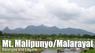
Malipunyo actually has three peaks with almost identical elevations, with the summit (Peak 3) rising to 1005 MASL. In April 2008, the summit has been cleared of trees to become a viewdeck. An plaster statue of the crucifix has also been erected. In this viewdeck, and elsewhere in the summit, one can see Mt. Maculot, Taal Lake, Mt. Atimla, Mt. Kalisungan, the Banahaw complex, and Mt. Makiling. The two other peaks -- Susong Dalaga and Manabu Peak -- are also visible.
Don't expect the views to be spectacular, though. Basically, the attraction of Malipunyo is its forests. Though not grand like that of Makiling, it has a rural feel. Fruits such as sintunis (a form of citrus) and sampinit (wild strawberry) grow in the slopes of this mountain. Animals such as wild boar, monkeys, and iguana are also claimed by the locals to be present in the mountain.
and camping at the summit affords cool breezes.
The usual staging-off point is Lipa. This city has become a major commercial center in Region IV; it has three malls and is readily accessible by the STAR Tollway. Buses regularly pass by Lipa on the way to Batangas City and other destinations in Batangas. From Lipa, tricycles can take you to Brgy. Talisay for Mt. Malipunyo (or Brgy. Sta. Cruz, Sto. Tomas) for Manabu Peak.
ITINERARY
Mt. Malipunyo Traverse to San Pablo
*see Malipuny0-Manabu Traverse described under 'Special Concerns'
Day 1
0800 Assembly in Manila (Buendia, Alabang, or Cubao)
0830 Leave for Lipa, Batangas (~P90)
1030 ETA Lipa, Batangas. Take early Lunch at Fiesta Mall
1200 ETD to Sitio Talisay.
1230 Reach Jump-off
1300 Start trek
1400 ETA water source
1700 ETA Summit. Set-up camp.
1800 Dinner / socials
Day 2
0530 Wake-up call. Breakfast
0600 Break camp
0700 Start descent to Atisan via 'Talahiban'
1130 ETA Brgy. Atisan. Tidy up.
1200 ETD for San Pablo City;
1230 Arrive at San Pablo; lunch
1400 ETD for Manila via buses from Lucena (P112)
1700 Back in Manila
SPECIAL CONCERNS
Transportation. From Manila, you can take buses going to Lipa or Batangas City (~P100). As much as possible, try to drop off at Fiesta Mall or anywhere near, where tricycles may be paid between P50-80 for a trip to Brgy. Talisay. Tell the tricycle to take you to the barangay outpost.
Logistics. A guide may be arranged at the barangay outpost. Look for the barangay officials, who will ask you to register on a logbook. They will also arrange a guide for you. As of May 2008, P500/day is the fee although it is customary to give an extra. Cellphone signal is present throughout most of the trail.
Technical notes. Noxious plants, including the pruritogenic (itch-causing) lipa trees (for which the city was named) are present in this mountain; it is best to take this in consideration in clothing selection. Trails are interconnected and quite confusing so be vigilant.
Only one water source are available in the above-mentioned itinerary so prepare 3-4 liters from that point. An alternative is to climb the summit by a daytrip. This is possible if you leave Manila by 0500hr. If you are very early and your pace is very fast, you can even do the traverse in one day!
Traverse trails. If a group intends to visit all three peaks of the Malipunyo range in one trip, then a Malipunyo-Manabu traverse is the best choice, plus a Susong Dalaga sidetrip. Although interconnected, the trail to Susong Dalaga branches off from the trail to Malipunyo early on from Brgy. Talisay. Thus, the recommended schedule is an early arrival at Brgy. Talisay on Day 1, and climbing Susong Dalaga early in the morning (1-2 hours up; 3 hours total). And then, after lunch, the group can commence the four-hour climb to Malipunyo summit, camp there, and then descent the next day to Manabu. The exit point would be Brgy. Sta. Cruz in Sto. Tomas. The reason why a Manabu-Malipunyo traverse is less preferred is that the guides at Brgy. Talisay seem to be more familiar with the entire range, and they can take you to all three peaks in two days. Just prepare allowances. If a traverse to San Pablo is desired, then an additional day might be required.
TRIVIA
At least three mountains are called 'Susong-Dalaga'; Jose Rizal called Mt. Tagapo in Talim Island as such; and another similarly-named mountain is found in Rizal. However, the shape of the Susong-Dalaga of Mt. Malipunyo is, in the author's opinion, truer to its name.
Other trails, including one from Tanauan, may also be used but these are more challenging and less-established. There is also a trail to Tiaong, Quezon from the summit.
In the olden days, young men of Brgy. Talisay used to do the traverse to San Pablo for another reason -- and perhaps equally adventurous: they would bring a guitar across the mountain, set off at dusk, and serenade the ladies of Brgy. Atisan in San Pablo! They would return on the same night.
Thursday, October 25, 2007
Mt. Malipunyo/Malarayat
Subscribe to:
Post Comments (Atom)


68 comments:
hi..are there guides in malipunyo? or the trail is defined enough to manage without a guide? thanks for the help
yes there are guides. ask for the barangay captain, there's a logbook at the barangay hall. the people there will give you a guide. the trails are quite confusing and i encourage you to take one. have a nice trek!
thanks for the reply.. is there a parking lot for private vehicles in malipunyo jump off? and how much is the guide fee? thanks.. more power..
i updated the entry, with information that i hope would answer your questions. as for parking, you can park at the jump-off. we did that when we climbed last april.
thanks man.. one last question.. From manila, going to malipunyo is the same as manabu's route right? thanks
yep. but the dropping off point is around 20 kilometers away -- lipa instead of sto. tomas.
Hi,
My group (FMDYDH Outdoor Group - FOG) is bound to Malipunyo this August 25-26, 2008, and this would be our first time to trudge this trail. We might need some confirmations and advise on this mountain though.
1. When we do the traverse trail, can we "actually" get to the three peaks of malipunyo-susong dalga-manabu? or are we just be "passing-by" the other peaks in a distance?
2. If we can go to all three peaks in our 2-day trip, would it be best if our entry point is from manabu to malipunyo or vice-versa?
We really do appreciate any inputs on the subject.
Thanks Gid!
@halumigmig: i'm editing the article to include a response to your question (under special concerns). have a nice trek!
hi sir! astig pala sa malarayat ang ganda ng view mula sa peak ng manabu pati sa malipunyo cleared na ung summit nya sayang lang hindi namin na-trek ung susong dalaga kasi kinulang na kami sa oras, ilan beses kami naligaw kaya nadelay sa oras... start po kami ng trek sa manabu then traverse to malipunyo last aug.22-24 ang sarap pala ng lomi sa brgy. talisay!!! hehehe...
mga sir magkano po ba pag magpapaguide paakyat sa mlarayta wala kasi samen nakakaalam ng trail nun e
@saku: congratulations on your trek! how long did it take you from manabu peak to malipunyo summit? how was the trail, is it easy enough to manage without a guide?
@payat: its 500/day as of may 2008 when i climbed malipunyo. you can try negotiating.
start po kami ng 8:30 bumutas na lang po kami ng trail mula sa manabu hanggang makakita ng malinis na trail.. cguro po mga locals lang ang nadaan dun kasi hindi bugbog yung daan then binaybay namin yung cogon line sa tapat ng susong dalaga ilan beses kami nag backtrack, 6:30 na po namin narating ang summit ng malipunyo kasama na dun ang lunchbreak at pahinga pati na yung pagkaligaw! hehehe...
mas advisable po na kumuha ng guide kasi ang dami pong mga sangang daan na iba't ibang lugar ang babagsakan, nagtatanong na lang kmi nun pag may nakikita na locals kaya namin na-traverse.. pero naglagay naman po kami ng mga trail sign sa mga dinaanan namin from manabu...
thanks saku for this. id like to do a malipunyo-manabu traverse too, soon. more power to your group and good luck in your future climbs!
tnx din sir sa pinoy mountaineer kami nakuha ng details pag may climb kami... sana magkita kita tayo!!!
@saku, thanks! hope to see you along the trail in the future/.
Hi Gid,
Our group FMDYDH Outdoor Group (FOG) finally managed to summit this mountain last Aug 26 despite the continuous downpour of rain. It was some sort of exploration since we secured no local guides at all (priced @ 500/day), all we had were information gathered through the net like pinoymountaineer.com and other blogsites. Our entry point is via Talisay where we met Sir Bong, the Brgy. Secretary. The trail was quite easy yet very tricky with its numerous, cascaded forks, we got lost eventually after reaching Vilma's Reforestration Project (there is a green reflectorized metal marker), but we were able to reckon the San Pablo (Manabu) return trail due to this misfortune. After calling Sir Bong on the phone and with obscure instructions at hand, we proceeded to go with our "basta pataas" mountaineer instinct and trudged a thickly-forested barely-visible 40to60-degree ridge trail and at 1630, we reached a clearing with grass forming a flat saddle. The saddle overlooks a nearby unknown town on the southeast. To our south, loomed Malipunyo summit, to our north, an unknown peak. Our energy is quite depleted due to numerous backtracking and reconnaisance attempts and the un-abating rains which made the trails ankle-deep with mud, so to keep our heads straight, we stayed there for the night and took some shots of brandy that we brought.
Before break camp of next day, to our delight, we saw a familiar face, Mang Mokreng (a local guide/forest-watch with a hut where we took lunch the previous day, who gave us directions before we got lost) with his 'apo' and his mangy dog. He then explained that we took the 'old and difficult' trail going up, and that we just missed the established trail just above the reforestration project. He also told us that the town we see below is in fact, Tiaong, Quezon (at least, we get to know the traverse trail to Quezon)! He then pointed us to the right direction towards the summit. Also he said we stayed the night at what locals call "pahinga", aptly named since you will have to rest here before (or after, when going down via Tiaong) you manage the full hour of 50to60-degree assault via the "Matandang Gubat" trail (full of noxious Lipa Trees!) that would reconnect on the left side of the established trail with an hour and a half left to summit.
The trip was quite an experience and is quite enlighthening especially for those exploration junkies like our group. Just a quick note to all those who are planning to climb this mountain range, do not underestimate this mountain. If you're less adventurous at heart, not vent on exploration, and is time constrained on getting to the summit (more like of what our group call as a 'social-climber' hehehe), it is a must that you secure a guide, otherwise, you'll definitely get lost somewhere along its forks and turns. Also, if you go down via Talisay, you can tidy up at Sir Bong's nephew's place, Sir Julius (who is also a Brgy. Kagawad) just in front of the barangay hall, you'll even be offered free Batangas-brewed (barako) coffee!
Regards,
Halumigmig
PS: I'll try to send some pics of the Tiaong trail on a separate e-mail.
Sir Bong (Talisay Brgy. Secretariat) Contact Nos: 09153655770 / 09287473062
@halumigmig:
getting waylaid in malipunyo seems a general experience --same thing happened to me last april; we ended up climbing an obscure mountain called mt. palamigan! we certainly should recommend getting guides for this mouuntain.
serendipitously though, you reached the tiaong trail! i shall await the pictures with great interest.
Mga Sir, our group has organised a climb to Mt. Malipunyo for this weekend. I'm a bit hesitant because of the comments i've been hearing and reading from most of the mountaineers who has gone to Mt. malipunyo. I am not ready to be waylaid this coming weekend as I still have sprained foot and been limping for two weeks now. But hardheaded as I am, I was able to get to one of the nicest destinatiion near Mt. Maculot with a very notorious trail down(as in almost 90 degrees)somehow, I was able to endure the pain and was able to get to our destination and back. I am afraid I might ask for Ecamp which I know would really upset my husband.
One of our group member was able to join a group to Malipunyo and she said that there's no way for us to get lost anymore coz there are trail signs already. Is this so?
another concern, would you know how many tents can the summit accomodate? (approx)??
thanks very much.
Maruco
akyat po ang kasaka des week cnu po gusto sumabay?
wat exact date ang akyat ng kasaka?
nakakaligaw talaga tong bundok na toh, may 4 friends ako na umakyat don just this saturday dec. 13, dapat today nakababa na sila dec. 14, nagtxt sila sakin just tonight naliligaw daw sila and decided to go down tomorrow! waah sana wag na sila maligaw bukas...
update lang nakababa na yung mga friends ko, sa brgy. sto.nino daw yung nilabasan nila, thank God.. siguro dapat yung mga tao sa barangay hall i-enforce nila na wag magpaakyat ng mountaineers ng walang guide, sobrang dami daw sangang daan kaya nakakaligaw talaga..
Sir Gid, if I may share our waylain story..
We were supposed to climb Mt.marami but due to a Millitary Cleanup Drive, we were told that it is entirely dangerous to climb. "Pwede kayo umakyat, pero pag nabaril kayo, sorry na lang. Baka mapagkamalan kasi kayong NPA.", was what the jump-off caretaker told us (hence, we really advise you to inquire first at the Magallanes Police Station if climbs are allowed - prolly due to Millitary operations). Stricken and disappointed. We travelled back to Dasmariñas, Cavite. It was late afternoon when we suddenly decided that we won't let this incident waste our prepared things. We got some ideas that we should try climbing Mt. Malipunyo via Talisay Trail (courtesy of this site).
We arrived at Brgy. Talisay at around 1800. Being stubborn and low on budget (fare to Mt. Marami is really costly), we decided on a night trek despite the notion of the locales.. "Naku, imposible ninyo maakyat yan. Tapos ganitong maulan at gabi pa? kahit bayaran ninyo kami ng P1000, hindi kami sasama. Feeling extremists and all adventurous, we pushed on. On the way to jump-off, we met a locale named Manong Sixto. He advised us to refrain climbing until the next day, so we gain clear vision of the trail. Being the idiots we are, we persuaded Manong Sixto to atleast give on some minor tips to reach the summit. He told us to turn left after the stream from the jump-off, for taking a right track will lead us right into Sto.Niño, the nearby barangay. He also chided that we just keep on staying right when on forks. Carrying that advise in hand, we proceeded with the "Sabi sa site, 5 hours daw trek, make it 6 kasi mabagal tayo.." idea and the "Basta PATAAS & Keep right approach".
To make the long story short, it took us 7.5 hours to realize that we are getting lost (started at 1830, stopped around 0200), and that includes a 30 min break. Feeling that we are getting hypothermia (due to a lack of training & the tropical depression brewing in), we decided to make camp at a clear patch of land with atleast 30 degrees steep.
Lesson: Don't take night treks on a totally obscure mountain. Being waylain is out of the question. If you intend to go on without a guide, take a geographical idea of what and where you are in the mountain, the direction to be took, and taking the exploration by daytime is obvious.
Night exploration sucks. Unforgettable moment was when I said this despite the morning haze of clouds, "Pre, summit na to, tama tayo oh! Sabi sa site kita Maculot! Success PRE!" Then after about 20 mins, the clouds unveiled higher peaks. That scene has LOSERS written all over it. :) peace! akyat lang ng akyat! God bless!
uno, that was quite an adventure you had, thanks for sharing it. as they say, experience is the best teacher!
marami talagang ligaw sa mt. malipunyo. last year naligaw din kami; we had the correct jumpoff point but we ended up climbing the wrong mountain! it was so obscure and unremarkable (mt. palamigan) that i didnt even bother to post it in this blog. haha!
keep on climbing!
man tanong ko lang kung pwd wala nang guide sa pag akyat, na bangit kasi sa special concern,
tulong naman.... salamat
Hello Laboy,
Yep pede d2 umakyat ng walang Guide, just be ready for the "lost trails".Climb early so that there is enough time for backtrack :)
I remember we climb ds in traverse trail night trek,so fun we just follow our instincts.
hapi climbs!LNT
thx....
may trail sign na ba paakyat ng malipunyo?
may climb poh kami this month, sana hindi kami maligaw, and try namin mag-traverse to
manabu peak
I hope na may trail sign din don,
anyone kung sino grupo na kakaakyat sa bundok?
matulongan nu sana kami,
salamat...
more power in this site....
Sir Gid at sa lahat,
Saan ung trail na sa Tanauan galing? Sana po mapost nio..thanks ulet..
to jan 25 anonymous....
magtanong tanong lang kayo sa brgy. talisay sa lipa, maituturo nila kayo.
madali lang ang akyat pero medyo madulas pababa.. dapat matindi ang preparation nyo....
kakaakyat lang namin....
@gid: may nasalubong po kami na local hunters at mukhang cloud rat yung dala nila pababa... though hindi ko talaga masabi kung anong klaseng mammal yun... di ko naman makuhaan ng litrato dahil malaki ang dalang itak ni kuya... hehe... hindi sya unggoy... mas mukha syang daga...
ei...confirm ko lang po base sa mga nabasa ko sa blog na to...akyatin na po ba itong bundok na to? mei narinig kase ako sa kasama kong mountaineer dati when we climbed Mt. Manabu...mei tinuro sha na katabing summit na inde akyatin thus binabahayan na po ng mga ahas...eto po ba un or iba pa un??? and assuming na tama ung way na tinahak nyu...maganda na po ba ung trail?? plan po kase namen umakyat next weekend...salamat po!
Ahh, actually kakaaykat lang namin dun kahapon actually kararating ko lang ng bahay ngaun.. nung nasa jump off kami tapos naghahanap kami ng guide.. ung una naming napagtanungan eh marami nga daw ahas dun.. pero nung umakyat kami wala naman.. (assuming kasi wala naman akong nakita at kung ito nga ung tinutukoy mong peak..may crucifix dun ni jesus christ kaso nakababa na ngaun).. 3 peaks ung napuntahan namin.. di ko lang alam mga names kasi nung tinatanong ko ung guide namin ang sagot niya Malarayat eh..(not sure)
Sa trail:
Yung trail sobrang enjoy! sarap!although may mga super steep na trek pero okei din.. ang sarap kaya ng putik.. kami nag enjoy, kailangan lang talaga ng BMC :D Pero saya ng trail ganda rin ng tanawin..kaya siguradong mageenjoy din kau..
Sa campsite naman..
Remind ko lang po para sa lahat ng mga may gustong umakyat po sa mt. malipunyo/malarayat.. napakaliit lang po ang campsite.. sana kumasya kayo dun pag akyat nio..un lang naman.. pero maganda sya pag small groups kayo.. kasi super liit talaga ng campsite.. un lang po..sana nakatulong po sa inyo!!
For a big group like ours (31 climbers), it took six hours to reach the summit. Going down, we got a bit lost after taking the left trail of the fork from the stream. We suspect it is an alternative trail going to the summit, complete with trail marks.
The campsite is very small. Roughly, the flat area can comfortably hold only about 4 tents. The right portion of the campsite (when you emerge from the trail) is sloping. Since we were tired and almost losing daylight, we decided to force around 7 or so more tents, instead of decending prematurely and look for an alternate campsite. Most of the guys slept outside in sleeping bags. Unpleasant to the back but fun during socials. hehe.
By the way, the crucifix marker no longer stands.
Salamat sa mga bumibisita sa Bundok ng Talisay...andito ang mahahalagang paalala para sa mga pupunta..
GUIDE RATE...ang rate ng guide ngaun ay 800 at 1000 pag overnight. kailangan nyo ng guide kasi maraming naliligaw for your safety na din..limited lang ang guides kaya first come first serve pero syempre gagawan kayo ng paraan pag wala na..
PAALALA..delikado ang bundok kapag ibang trail at gumawa kayo ng inyo...kasi baka mapadaan kayo sa daanan ng mga wild pigs at mapadpad sa ibang part ng bundok...sinisigurado ko sa inyo sabog ang bungo nyo hehehehee...hindi naman joke lang ...binti lang... pede pang gamutin...kasi maraming locals sa kalapit barangay na hanggang ngaun ay yun ang pinagkakakitaan...naglalagay sila ng BITAG...anu yung bitag? baril na may tali ang gatilyo ..pag nadaanan nyo ang tali puputok syempre ang baril jan na magsisimula ang kalbaryo nyo...hindi siya kayang gamutin ng band-aid for sure..kaya dun sa mga matitigas ang ulo magdala na lang kayo ng diaper in replacement sa band-aid baka kakayanin..
salamat sa mga sumusunod ng rules ..register sa brgy. hall...20 per head yata..
ang rate ng transpo sa tricycle mula sa fiesta mall papuntang Brgy. Talisay ay 40 lang ..50 siguro pag kayo.. kasi mabigat ang mga bags nyo..
eto ang mga contacts para ihanap kayo ng guide...
Kuya Bong (brgy sec.)09287473062(minsan nasa manila)
Arvin 09165086715(local resident pedeng tumulong pero hindi gumagawa ng bitag)(pero may work to kaya minsan baka hindi sumagot sa text nyo kasi bawal ang cel sa trabaho)
Yolly galay 09154115420(brgy treasurer)(binabayadan ng 20 pesos) (tsaka ng sa tour guide yata)
Gado 09269266962(hepe ng tanod)(pag walang work to pedeng sya na din ang guide nyo)
kap 09167912769 (namomroblema sa mga mountainers na psaway na hindi nagpapaalam pero pag naligaw ay humihingi ng tulong sa kanya)
Atams 09195212132 (pede ring makatulong pero bihirang magload kaya pag hindi nagreply alam nyo na.)
konsehal edring 09077684625 (pag wala pang sumagot sa mga nauna, siya na lang ang last option na pede nyong hingan ng tulong.)
sir gid,
sana magawan nyo ng blog or advisory yng mga namamaril sa malarayat kc dumadami na yng mga local mountaineer dun na namamaril ng mga ibon at naguguha ng kng anunung hayop na nahuhuli at napapatay nila minsan pag daan nmin kala mang piring kinakatay na nila yng malaking ibon.pag di nahinto to mauubos na lahat ng nakatirang kng anu anu dun.....sana magawan ng paraan...
update nmn po bout malipunyo . tnx
hi poh!!! we're planning to climb this weekend ok poh b ang trail? mga newbies poh kmi at 3 lang kmi hehehe masyado bng adenturous? wla poh bang may aakyat n pwde nmning samahan? kng meron po pwde pasabit nmn kmi thanks poh
Was there for an overnighter last Friday. The trail's beginning to blend into the surrounding greens, our guide had to hack our way up. NEVER EVER CLIMB WITHOUT A GUIDE... The threat of traps built with 12-gauge shotgun casings ARE REAL... Our guide even brought some so he could refill the ones that had been set off...
Guide fee was 800.
Inform Kuya Bong days or even a week before you go there. The summit campsite can only accommodate at most 5 tents.
Don't bother finding the baranggay hall. They'll point you towards Ate Yolly's house anyway.
Baranggay Talisay's water supply runs on an "alternating" schedule... So you could wash up either at Ate Yolly's, or Kuya Bong's, depending on whose house has running water that day.
One of us had a "limatik" crawling down his neck. So limatiks maybe making a presence there as of late...
Different guides seem to take different routes. On our way down, we could hear a large group making the way up, but our paths never crossed. Our guide took us through the trail that passes through a small "batis" (which may be the water source Gideon refers to).
Our guide also did not advice traversing (if you could call it that) to Manabu... Well he couldn't take us there anyway... He told me that they got lost (or couldn't find the way) the last time they attempted to cross to Manabu, even with people from the NAPOCOR Station at the jump off...
Oh yeah... SITIO TALISAY IS NOT THE SAME AS TALISAY, BATANGAS... Rent tricycles beside Fiesta Mall to get to the "right" Talisay...
been here also, we did the night traverse side from w/c we passby to the Napocor tower under it and the trail at first was easy,upon nearer to summit the trail was steep & untraced maybe bcoz no one leading the trail.I agree that u can lost here for so many trails whichway is.But all in all it was a memorable climb.
hapi trek!
sir mgandang araw sa inyo. So talagang kinarir na nung mga locals dun ung pamamaril nla ng wildlife? kakapanghinayang.
btw, napakagandang experience tong Malipunyo, mababa lng sya pero my "thrill", bukod sa mdaming ligaw npakasarap pang mg-short dahil sa "dahon ng lipa" hehehe. mgandang training ground dn sya bukod sa Makiling na malapit sa manila for the newbies pra matuto sa mga sangang daan.
the usual route we take is from talisay to Sto. Niño, pwedeng i-dayhike kung gugustuhin. Dati inakyat namin to thrice within a month, unfortunately that was the month kasabay nung race na ginawa dun. ayun, sa tatlong akyat, 3 ibat-ibang trail ung dinaanan namen sa Talisay bago kami nkarating sa water source (malapit sa kubo ni Mang Rey na pinsanin ni Tatay Tino sa manabu hehehe).
gusto ko din ishare experience ko nung maligaw ako sa malipunyo. traverse Talisay-Sto. Niño dayhike plano nmin, nkarating kami agad ng summit ng lunchtime, past 1 pm pababa na kame sa Sto. Niño. Sa hndi ko malmang kadahilanan (sa ulan cguro), eh pgkalampas ko sa "Palamigan" (viewpoint ng Maculot), bigla ko naligaw at pagkatapos ko umakyat ng tower ng Napocor at 2 oras na pghahanap ng trail (na hindi ko na nkita), nkarating ako sa isang private resort sa may Talisay (ulit).. dahil dun d2 na kme sa manila ulit ngkita ng mga kasama ko hehe..
madaming pang kwento sana kya lang kkapgod basahin, so goodluck sa mga gustong maexperience Malipunyo and enjoy the climb. hahanaphanapin nyo to after ilang days palang.
Nga pala sana ung ibang climbers dun iwasan ng magiwan ng basura sa summit or kung kaya nmang ibaba ung mga kalat dun pakisabay nalang, kc nun last climb ko dun andami basura sa summit. may mga bote ng mineral water, lata ng corned beef at sardinas, at kung anu-ano pa. mukhang di kc alam nung ibang climbers ibig sbihin ng LNT o talagang basura lang ugali nla. Sir maramimg salamat sa space...
Just compeleted a day climb last May 9. Tricyle from fiesta mall to Talisay is 150 php, registration is 10 php, and guide is 800 php. According to our guide (Rey), only 3 persons are authorized by the barangay as guides.
reminder: kapag sumakay kayo ng tricycle wag nyo n lang itanong kung magkano...basta mag abot n alang kayo ng 50 pesos...ayus na yan kasi ang regular talaga 40 lang...sabihin nyo n alang suki na kayo...
last week lang... 5 atenista umakyat sa bundok ng malipunyo naghire ng guide nawala ....bakit?
eh kasi gusto nila san pablo sila bababa..syempre ang guide ng talisay ay bundok lang ng talisay ang sakop pagkatapos silang maihatid sa boundary ng bundok ng talisay at sanpablo itinuro na lang ng guide kung san sila dadaan pababa ng san pablo..
ang siste ...mga baguhan pala at first timer lang ayun naligaw sila papuntang brgy. atisan...
pano narecover? ganito..kumuntak sila sa friend nila sa manila para makontak ang taga talisay..si kuya bong..sa kanya humihingi ng info tungkol sa umakyat....beforehand sinabi na namin na ang guide ay hanggang bundok lang ng talisay ..ganun din ang sinabi namin sa tumawag..kaya sabi namin wala na sa malepunyo ang subject..nandun na sa brgy. atisan..basta ang advice namin bumalik na lang sila at susunduin sa talahiban ...kaso naligaw na rin sila kasi hindi alam ang pabalik...
anong nangyari...kumuntak sa krame ang kaibigan nila ..tumawag sa batangas provincial ang krame ..nataranta ang mga sundalo ng batangas pati general..sumugod sa talisay..nagulat din ang mga tao sa barangay..lalo na ang mga matatandang may bakas pa ng world war II....to be continued..
commercial muna: BURGER ...dahil may mga bisita si kap umorder ng burger para sa mga sundalong gutom na gutom pero hindi agad makain ang burger..kasi busog pa pala si general kaya hinihintay ng mga sundalong gutom na magutom si general para kumain ng burger..para makakuha na sila dahil kailangan mauna pala si general...hanggang tumikim na rin ang genral dahil sa pagpipilit ng naghanda...ayun happy ending kasi nakakin na rin ang lahat..
o tuloy na tayo sa kwento.....5:00 nang madaling araw umakyat ang mga sundalo sa bundok...dahil ang location daw nung 5 ayun sa kanila na ipinasa lang ng friend nila dahil drain ang batt nila ay nasa lugar kung san may isang kubo sa gitna ng niyugan....kung saan wala namang niyugan sa bundok ng malipunyo.. dahil sa tapang at lakas ng katawan ngmga sundalo ..sinuyod nila ang bundok at ang subject ay natagpuan sa brgy. atisan...kaya sa san pablo na lang sila bumaba kasi malapit dun..
masaya ang lahat..mapwera sa isang sundalo na bumalik magisa sa brgy talisay kahit pagod na para lang sabihing nakita na ang bida...
anong aral ng kwento.? kanya kanyang enterpretasyon lang yan..
Salamat sa pagliliwanag Sir...sana di na rin maulit ito..
commercial muna..^_^
hapi trek!
Hi!
I created an Mt.Malipunyo site on SummitPost, with attached maps that may help mountaineers not being lost. The address of the site is this:
www.summitpost.org/view_object.php?object_id=521158&confirm_post=7
Best regards,
SzaniUherkovich
(from Hungary)
@SzaniUherkovich
Thanks a lot my friend..great help!
Me and my team will climb Mt. Malipunyo tomorrow, Thanks to this site we won't be walking in the dark.
I'll comment again on monday to share our experiences. Wish us luck.
Mt. Malipunyo here we come!
sir, sama aku ndi ku pa kc naakyat malipunyo e,.
just a correction that peak is not susong dalaga its bagwis peak
hi sir gid, we did climb here oct 17, masarap trail nya madami nga lang ligaw.. na help lang kame ng friend namin si brian ng watakerz mountaineers thru text & call sa cellfone... kaya lang dun kame napadaan sa wild boar trail which is may trap nga na using shotgun bullets.. pero ok naman sya direcho taas pag labas mo talahiban na..bale yun una stream direcho lang then lalabas yun kubo.. satapat nun kubo mismo trail direcho talahiban.. then from talahiban is yun ridge na this time because of PEPENG & ONDOY.. inaccesible sya... bale 3 kame & 1 newbie umakyat.. super sukal yun ridge na madami tinik at sanga nakaharang sa trail.. i used my trekking pole para slammin yun nabubulok na mga sanga ... wala kame ni rent na guide pero siguro kung yun aakyat dito na mag papaguide, ok kung may dala tabak yun guide para mabuksan trail.. ( sana tabakin lang nya yun bulok, wag yun fresh.. sayang eh ) inatemp muna namin ng friend ko butasin with our bare body hehehe at last naabut nmin yun malipunyo with lots of sugat.. kaya lang wasted na newbie namin kaya inabort ko.. gud decision naman kasi pagbalik sa kubo inapoy na ng lagnat hehehe kaya di na naka mamam.. na monitor naman namin lagnat nya kaya pag gising kinabukasan palong-palo na ulet.. pero syempre pababa na kami kaya hapi pictures na lang sya... masaya nman sya sa una nya climb so direcho lang ulit sa akyat.. hahaha.. balik na lang kame ulet traverse na para maka bawe hehehe.. thanks sir gid more power 2 u.. txt txt na lng tayo if tuloy tyo natib.. bye - KARL of PIKNIKERS MOUNTAINEERS www.piknikers.com
gud nun ser ma'm ask q lang kun magkaiba vah yung manabu and malarayat o anung pinagkaiba nila? carl of dahon pasensya na ala kami idea sa dalwa dami xe hakahaka na isang hilera lng cla eh pls lapit na xe kami panik sa manabu eh tnxxxxxxxxxx
Hello Guys
Last Nov. 18-19,2009 we climb this mountain and it's a great experience for us. We travel from Dasmarinas, Cavite with 10 companion including me. Were just a freelance mountaineer
from Analog Devices Inc. Gen. Trias, Cavite.
After a not so long trip and a good view from
Taal Lake, we arrive @ Fiesta Mall and a little chicha sa canteen. Alis na ang tropa papunta sa jump off. Sa Sitio Talisay kami nagregister at don na rin kami kumuha ng guide
which become interesting to us. Dahil po ang binigay sa amin na guide ay di naman sa nanghuhusga ay may polio ang binigay sa amin.
At first glance napaisip kami kung kaya ba nito magguide sa amin. But as we go along and know him e ang lakas pala nya at kabisado ng husto ang Mt. Malipunyo since his doing that for 4years na. His name is Mang Reynald Lobo.
Kuya Tatay ang tawag namin sa kanya. Mabait sya at maasikaso sa amin. Libre pa ang kape namin kasi lagi syang nagtitimpla ng kapeng barako sa amin. He knows very much of the trail. Nahirapan lang sya ng konti dahil ang taas na ng mga damo at mga nakaharang sa trail
kaya panay ang tabas nya ng damo para magkaroon
ng trail. daming puno ng nagbagsakan sa trail dala narin siguro ng 2 bagyo na dumaan. madulas ang trail, maputik at ang daming nakaharang ng mga sanga kaya kelangan gumapang ng konti. wala na ang mga patibong kasi ang sabi wala na rin daw mga baboy damo don. sayang
di tuloy namin naexperience ang makakita nga mga baboy damo. at last we sumitted after 6hrs dahil nga po sa bagal namin kasi kelangan pa namin iclear ang nga harang sa trail. Maganda sana kaso sa sobrang kapal ng fog di namin nakita almost ang view, ang tagal ng clearing.
ang sarap ng experience, lalo na ang tinola na walang asin. Ingat lang po at medyo madulas ang trail lalo na madalas umulan.
Tip ko lang po if ever po na umakyat kayo ng Mt. Malipunyo at kukuha kayo ng guide si Kuya Rey na lang hanapin nyo. The best guide sya.
Jess. The Tinola King....
Pendong....
been here last nov. 21-22. So lucky na isinabit ako nina sir nightcreature and sir marion. Medyo malupet ung trail kasi medyo inabot kami ng ulan. Thanks to sir Marion kasi he's the one who guided us. Lots of confusing trails because he himself and sir Karl of Piknikers were victims of those trails (hehehe....).When we reached the summit eh me clearing pa pero it only last for an hour. We experienced strong winds during midnight. Sarap sa taas.... Lalo na nung socials na kasi sir Karl brought with him a liter of Fundador. Ok ang jam namin kasi it was my first time to climb with them. Ang pinakamasaya eh nung pababa na kami kasi napakadulas ng trail. Sa tingin ko nga mas matagal pa ung pagbaba namin kesa pag-akyat. Once again thanks to sir marion, sir nightcreature, and sir Karl.... til next time!
Our group will try to scale this mountain... jan 23-24 if ever may ibang groups n aakyat maybe we can tag along...
Any updates po sa mga latest na umakyat d2?
Plan po namen nxt mo feb. d2,kung cnu gus2 sumabay post lang kau. salamat
team dionisia,
sir/ma'm
end of feb. po kame!.. bka pwede makisabay!
ty
-gboy
Feb 27-28 is our plan to scale Malipunyo.
Kita-kits po!Salamat
team dionisia,
team dionisia,
tuloy ba kau dis end of feb?
tanung lang.,
sa mga nkaakyat n ng malipunyo,
tanung lng po..may dala na kaya ung guide ng sarili nyang tent? o kme p magpprovide? o nde n nila kelanagn ng tent.. hehhe!
ty!
-gboy
Reminder: Bitag for wild pig is not a joke... tama po ang comment sa taas not to create your own trail specially at the back of Mt. Manabu facing San Pablo.
hello team dionisia.
im dyan grace of lipa city..
gusto ko pong sumama sa inyo..pwede po ba ako?09064577866 just text me po salamat..pero gusto ko pa sana sa mt. banahaw umakyat..type nyo rin ba?
good day,
hi team dionisia,
pa update naman po.since umakyat kau end of feb. thanks!
Sa mga aakyat ng malipunyo..medyo ingat lang po kaci madami po talaga ligaw..naka dalawang balik na ako don.naranasan din naming maligaw,pero wala naman po kaming nakitang bitag na cinsabi nila.ligaw pa madami...me iniwan po kaming trail sign red na rebbon kung saan kakanan ka sa tamang trail paakyat..pero sadya cigurong tinatanggal para lang hindi malaman na iyon talaga ang tamang trail paakyat..kung titingnan kaci hindi mo masasabing trail talaga yon..ang palatandaan lang po don eh.me dalawang puno na magkatabi na madaming bunga na bilog..madali lang makita yon kaci yon lang ang puno na me bunga don.ang guide naman po ay dipende kung kasama nyo cya mag damag ay ciguradong mahal...or ihahatid lang kayo sa summet tapos iwan na kayo don...ingat po kung gusto nyo pa ng ibang info ito number ko or pag free ako pede ko kayo samahan. 09208022339/09153791054
my purpose kaya tinanggal ung iniwan nyo'ng trail sign at dahil un sa LEAVE NO TRACE principle..kahit ciguro cinong mountaineer ang makakita nun tatanggalin tlaga un...
A special concern to everyone tungkol sa guideship fee it so very expensive daig pa ang umakyat ng mga Major Mountains.
magkanu po ung pa guide? same as above p rin po ba?? tnx!
mga sir yan ang problema sa mga umaakyat akala nila e tama yung basta na lang iiwan yung mga trail sign ,ribbons .tinatangal po yan ng sweeper.. dapat pong malaman na yun po ang ibig sabihin ng LNT. principles.
Post a Comment