
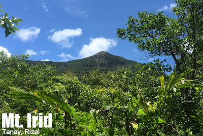
Mt. Irid in Tanay, Rizal (1,467+)


MT. IRID
Tanay, Rizal
Major jumpoff: Brgy. Sta. Ines, Tanay
LLA: 14°47′20.9′′N,121°19′28.3′′ E, 1467 MASL (+1207)
Days required / Hours to summit: 1-2 days / 5-8 hours
Specs: Major Difficulty 6/9, Trail class 1-4
Features: Tropical rainforest, limestone formations, scenic views of the Sierra Madre
Article history: Created June 11, 2015
Author: Gideon Lasco
BACKGROUND
One of the keystone mountains of the Sierra Madre, particularly in its southwest section, Mt. Irid in Tanay, Rizal is located near the the tripartite boundary of Bulacan, Rizal, and Quezon. Rising to 1467 MASL (1441-1469m in some accounts), it towers above other Rizal destinations such as Mt. Sembrano (769m) and the nearby Mt. Batolusong. With lush, second growth dipterocarp forests reminiscent of Mt. Banahaw, and an outstanding array of flora and fauna, Mt. Irid offers a deeper immersion to the woods for the Manila hiker used to the likes of Pico de Loro and Mt. Maculot. Nepenthes sp. and Rafflesia sp. if you’re lucky and at the right time – will delight botanists, while the crown-bellied fruit dove, Luzon bleeding-heart, and the Rufous hornbill are just some of the avian wonders awaiting birders. As for hikers, its forested ascent and eleven river crossings likewise offers a greater challenge, making it either an intense dayhike, at par with a Banahaw or Tapulao dayhike, or a most worthy overnighter – possibly in combination with Mt. Tukduan Banoi. The scenic views at the top make it well worth the effort, and given its elevation, the views are similar, but arguably grander than that of Mt. Pamitinan.
Access to Mt. Irid has never been easy. In the past, armed insurgency has dissuaded many hikers from considering the Sierra Madre as a hiking destination in general, and eastern Tanay in particular. To date, the area remains militarised, and it is not uncommon for the mountain to be closed due to ‘encounters’. However, the military is now cooperating with the barangay and allowing passage to hikers, and there has never been any report of unpleasant encounters with insurgents.
The trail to Mt. Irid traditionally begins from Brgy. Sta. Ines, which as of 2015 is accessible only by rough roads transected by several steams. From Brgy. Sta. Ines, hikers would pass through two sitios (villages): Sitio Kinabuan and Sitio Sadlac. Kinabuan has a namesake waterfalls, Kinabuan Falls, that is a nice sidetrip, while a little past Sitio Sadlac, 2-3 hours away from Brgy. Sta. Ines, is the traditional camping ground. There are stores for basic commodities as well as water sources in both villages.
Past Sitio Sadlac is where the real hike begins. After going up some agricultural slopes, the trail enters a beautiful forest with a continuous ascent all the way to the summit. The forest, typical of Sierra Madre mountains, is teeming with wildlife, including limatik (leeches) that are more of a nuisance than harm. Over 800 meters is gained in this manner, topping a total of 1200m of altitude gain. The upper reaches are rocky and very slippery when wet.
At the summit, the limestone formations offers splendid views of the (still) verdant Sierra Madre mountains, and a glimpse of the Southern Tagalog region, including Laguna de Bay and some of the prominent peaks such as Mt. Banahaw (SSE) and Mt. Makiling (SSW). And of course on the opposite side lie the nameless, countless peaks of the range. What a great reward after a nice hike! Indeed Mt. Irid is a highly-recommended first major hike in the Sierra Madre!
ITINERARIES
OVERNIGHT
Day 1
0500 Leave Manila for Antipolo (Cogeo Gate 2)*
0600 Take jeep from Antipolo to Brgy. Sta. Ones
0730 ETA Sta. Ines. Register, secure guides.
0830 Start trekking
1130 Lunch at Kinabuan Falls
1330 Resume trek
1530 ETA Sitio Sadlak
1630 Arrival at Mt. Irid Basecamp. Set up camp.
1800 Dinner / socials
Day 2
0400 Wake up call. Breakfast.
0530 Start summit assault. Earlier is better
0900 ETA summit of Mt. Irid
1000 Start descent
1200 Back at campsite. Lunch.
1300 Break camp. Head back to Brgy. Sta. Ines
1530 Back at Brgy. Sta Ines. Tidy up.
1630 Head back to Manila
1930 ETA Manila
*Note: For small groups habal-habal to Batangasan then jeepney rental or commute thereafter. Add 30 minutes.
OVERNIGHT (COMBINED WITH MT. TUKDUANG BANOI)
Day 1
0500 Leave Manila for Antipolo (Cogeo Gate 2)*
0600 Take jeep from Antipolo to Brgy. Sta. Ones
0730 ETA Sta. Ines. Register, secure guides.
0830 Arrival at Tukduang Banoi junction
1130 ETA summit of Mt. Tukduang Banoi, Lunch.
1300 Start descent back to Sitio Kinabuan
1500 Back at Sitio Kinabuan. Proceed to Sitio Sadlak
1700 ETA Sadlak basecamp; set up camp
1800 Dinner / socials
Day 2
0400 Wake up call. Breakfast.
0530 Start summit assault. Earlier is better
0900 ETA summit of Mt. Irid
1000 Start descent
1200 Back at campsite. Lunch.
1300 Break camp. Head back to Brgy. Sta. Ines
1530 Back at Brgy. Sta Ines. Tidy up.
1630 Head back to Manila
1930 ETA Manila
DAYHIKE
0300 Leave Manila for Antipolo (Cogeo Gate 2)*
0400 Take jeep from Antipolo to Brgy. Sta. Ines
0530 ETA Sta. Ines. Register, secure guides.
0630 Start trekking
0800 ETA Sitio Kinabuan
0900 ETA Sitio Sadlac
1000 First rock formation
1100 Second rock formation
1200 ETA summit of Mt. Irid. Lunch.
1300 Start descent
1400 Back at Sitio Sadlac
1500 Sidetrip: Kinabuan Falls
1600 Head back to Brgy.Sta. Ines
1730 Back at Brgy. Sta Ines. Tidy up.
1800 Head back to Manila
2030 ETA Manila
*Note: The dayhike itinerary assumes moderate pace with minimal stops.
PRACTICALITIES: IRID
|
Transportation
|
Public (1) Van, EDSA Crossing to Cogeo Gate 2 in Antipolo (2) At Cogeo Gate 2, take jeep and get off at ‘Batangasan’ junction where there is an entrance arch for Brgy. San Andres (3) Take a habal-habal to the barangay (P150/person).Alternatively, travel to Tanay, Rizal and take the twice-daily jeep (1200H, 1700H? – please confirm) that goes to Brgy. Sta. Ines
Approximately 2-3 hours travel time because of various stops and delays. Private. Follow the Marcos highway to reach the Batangasan junction. Park there and take a habal-habal to Sta. Ines, or if you have a 4×4, you can go all the way to Sta. Ines. There are several river crossings though and the rivers swell after heavy rains so I wouldn’t advise it. Approximately 1.5-2.5 hours travel time. |
|
Registration
|
Note: Prior written permit must be secured beforehand. The permit can be coordinated over the phone with the numbers below, and can also be done by email (tanaymenro@gmail.com) 1 week before the hike proper. Include a “letter of intent”, the names of your participants, and a contact number. The written permit will then be handed to you during the hike.
(1) Logbook at the barangay hall (P20 registration fee) |
|
Available; assigned at the barangay hall. 1250/2 days and 700 for dayhike
Required? Yes. |
|
|
Kagawad Toto: +639302355562
Pitoy- +09293265454 or 09263652353 Contact either of the two for assistance in securing the permit beforehand. |
|
|
Campsites and waypoints
|
Camping is possible in Sitio Sadlac and Sitio Kinabuan. There are also some flat areas in the forested ascent.Brgy. Sta. Ines 14°42′30′′N 121°19′42′′ E 426 MASL
Kinabuan Falls 14°45′34.5′′N 121°19′19.7′′ E 514 MASL Second rock formation 14°47′16.5′′N 121°19′22′′ E 1200 MASL |
|
Water sources
|
Sitio Kinabuan, Sitio Sadlac
|
|
Cellphone signal
|
+/- Sporadic at the summit and >1000m
(+) Smart (-) Globe at Brgy. Sta. Ines |
|
River crossings
|
Eleven river crossings from Brgy. Sta. Ines to Sitio Sadlac. Exercise caution especially during the rainy season or after heavy rains as the rivers can become impassable or precarious.
|
|
Roped segments
|
None
|
|
++
|
|
|
++
|
|
|
Rattan
|
+
|
|
Hiking notes
|
The rocks on the final ascent — not just at the top – can be very slippery.
|
|
Sidetrips
|
Kinabuan Falls and other waterfalls along the river system
Mt. Tukduan Banoi Mt. Batolusong |
|
Alternate trails
|
Possible traverse to General Nakar, Quezon and many other possibilities. Trails exist but it is important to coordinate with the authorities about security.
|
|
it is possible as an extended dayhike with moderate pace (5-6 hours up, 4 hours down). Logistically challenging.
|
|
|
Facilities at jumpoff
|
(+) Sari-sari stores
(+) Carinderias / paluto (+) Wash-up / shower places (+) Habal-habal rental |
|
600-800 (dayhike)
800-1000 (overnight) |
MT. IRID PICTURES
 |
| Crossing one of the many streams en route |
 |
| Approaching the forests of Mt. Irid with Mt. Tukduan Banoi at the background |
 |
| Past the campsite, the trail is forested and rocky |
 |
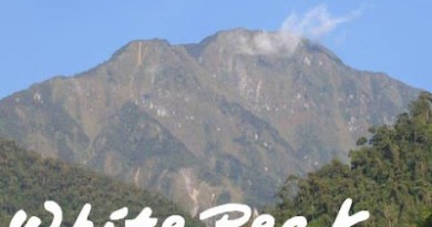
| Spectacular views atop Mt. Irid’s summit |
 |
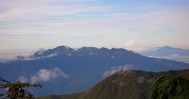
| View of the Banahaw Trilogy from the Mt. Irid trail |
 |
| Kinabuan Falls, a sidetrip possibility just a few minutes off the trail |
TRIVIA
Though there have always been trails in and around Mt. Irid, we acknowledge the efforts of Simpson Domoguen and other mountaineers for pioneering the recent spate of hiking activities (2010-present) in Mt. Irid and Mt. Tukduan Banoi.
This itinerary is based on the blogger’s dayhike up Mt. Irid in June 10, 2015 (see Hiking matters #467, forthcoming).
Leave a Reply
2 Comments on "Mt. Irid in Tanay, Rizal (1,467+)"
we will climb here this coming nov 28-29 2015, welcome sa group kung sino gustong sumama. email me @ tigabundok@gmail.com para maisama ko kayo pag nag secure ako ng permit para sa grupo.
Hi Sir Gideon. May info ka po ba kung may babyaheng jeep na from cogeo to batangasan ng 3am or 4am? At kung may masasakyang jeep din pabalik ng mga 6pm? Balak po namin mag day hike sa June 26. Salamat