
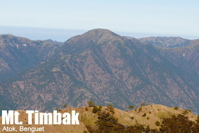
Mt. Timbak/Singakalsa (2,717+)


MT. TIMBAK/ MT. SINGAKALSA (2,717+)
Atok, Benguet
Major jumpoff: KM. 55, Atok, Benguet
Elevation: 2717 MASL (#9)
Days required / Hours to summit: 1 day / 1.5-2.5 hours
Specs (Backtrail): Minor climb, Difficulty 2/9, Trail class 2
Features: Village life, mummies, views of major Cordillera peaks
Article history: Last updated 041813
BACKGROUND
More than five years since Adonis Lloren shared to us information on Mt. Timbak – then also known as Mt. Singakalsa – this mountain has become a permanent part of the repertoire of Cordillera mountains, usually done as a dayhike from Baguio or a constituent hike of the ‘Luzon 3-2-1’ which combines the three highest peaks of Luzon in one hike: Timbak, Tabayoc, Pulag. Trail runners have also discovered the Timbak Traverse, which takes a rough road to Kabayan, Benguet. Mountaineering seeking to complete, or at least have a sample of, the Ten Highest Mountains of the Philippines, also know Mt. Timbak – the ninth highest peak in the Philippines – to be the easiest of them to do. Over the past five years, PinoyMountaineer.com had the opportunity to visit the mountain a couple of times, most recently in March 2013.
The hike can begin at Halsema Highway, but as of 2013, there is a cemented road leading to Timbak Elementary School, which is just 40 minutes away from the summit. So if you have your own vehicles – or if you rented a jeep as part of the Luzon 3-2-1, it is possible to just trek from the elementary school. If you don’t mind walking on the cement road, however, you will have to walk an additional 45 minutes to 1 hour.
The scenery features mostly villages and vegetable fields. At the summit, there are three crosses in what is dubbed as ‘mini-Calvary’. Seas of clouds form, and you can view Tabayoc, Panotoan, and Pulag (what the old timers dub as ‘Tapanpu’) and the range leading all the way to Mt. Ugo. Closer to the mountain, on the opposite side, you can see the Halsema highroad snaking through the town of Atok.
Around thirty minutes away from the Elementary School along the road to Kabayan are the Timbak mummies, which are probably a more culturally-significant destination. Once you come upon some houses along the road, ask for the caretaker of the mummies; he holds the key to the caves. An ‘entrance fee’ of P40/person is asked, but you will be amazed at how informal the way things are. Opening the mummies is discouraged, because the act of opening them exposes them to the air, which diminishes their state of preservation.
You can actually take the road all the way to Kabayan barrio. Adonis Lloren describes the barrio: “There runs a tributary of the Agno river lined with a long high stone wall along one of its sides. The wall’s color is comparable to that of the grand canyon. You can have a cool dip here. Some locals say that the water’s warm during the early morning but we never experienced that. just across the river is the huge Tinongchol burial rock. The stone, they say, houses three chambers of mummified ancestors of the kabayan natives.” Truly the rewards of this trek are abundant but the development of the road has made it more of a walk than a hike — even as it remains steep, gaining a thousand meters in a course of several hours.
ITINERARY
KM. 55: DAYTRIP FROM BAGUIO
0600 From Baguio City, take bus bound for Sagada or Bontoc
0900 ETA KM. 55, start trek
1030 Arrival at Timbak Elementary School. Head for summit
1100 Arrival at summit, talk with locals, early lunch
1130 Back at Timbak Elementary School. Proceed to visit the Timbak mummies
1200 ETA Burial Rock keeper’s house; take pictures. Nice view deck.
1230 Head back to Timbak Elementary School
1300 From school, start descent
1430 Back at KM. 55; visit Highest Point in highway then/or await Baguio-bound bus
1700 Back at Baguio City
SPECIAL CONCERNS
Getting there. The staging-off point to Mt. Timbak is Baguio City. From there, you can take buses plying the Baguio-Bontoc or Baguio-Sagada route. Options include the Rising Sun bus liner, which has hourly trips, the Lizardo bus lines or other buses from Dangwa terminal. Ask the bus conductor to drop you off at KM. 55; you will see the trailhead/road going upwards on your right. The trail being also the village road makes it well-established and there are locals to ask for directions.
Guides and permits. No permits are necessary to climb this mountain; and no guides are needed unless you want to have someone to talk to about the culture.
Hiking and camping notes. Cellphone signal is present throughout the trail and there is even a sari-sari store in the village. There are camping grounds but if you wish to request for a stay at the locals’ huts, you should do so with utmost respect and sensitivity to the locals. Of course being a high mountain the temperature is cold in Mt. Timbak, so prepare accordingly.
MT. TIMBAK PICTURES
 |
| This was the original photo used as the cover for this article – from Nov 2007 to Apr 2013 |
 |
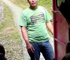
| The blogger at Mt. Timbak’s summit on Mar 2013 |
 |
| View of Mt. Tabayoc and Mt. Pulag from the highway to Kabayan |
 |
| From the summit, you can see the Halsema Highway meandering through the mountains (L). |
The Halsema highroad point near the jump-off is the highest point in the Philippine Highway System, officially at 2250 MASL.
The Kabayan mummies rank among the greatest cultural treasures of the country even though they continue to be largely unknown. Discovering Archaeology (a US magazine) featured the mummies in 2000 — and they have cited by Monument Watch as one of the Top 100 Most Endangered Sites in the world.
PinoyMountaineer prefers Mt. Timbak as the name of this mountain, since it is the one locals use. In equivocal names, priority belongs to the local name which is sufficiently known among outsiders. In the case of Mt. Iglit in Mindoro, the local name ‘Mangibok’ was not used because it is virtually unknown and would be inconvenient for readers of the blog. Etymology of mountain names has a special place in this blog, and a priority is also sometimes given to original names with cultural roots vs. popularized names, i.e. Magdapio vs. Pagsanjan falls. In the case of spellings, the more commonly used is given priority (i.e. Pulag vs. Pulog; Banahao de Lukban vs. Banahaw de Lucban).
PinoyMountaineer thanks outdoorsman Adonis Lloren for generously providing detailed infos on Mt. Timbak om its original version posted in November 2007. The author would also like to thank Aling Edna of Timbak for giving directions during his solo climb on Dec. 27, 2007.
Leave a Reply
39 Comments on "Mt. Timbak/Singakalsa (2,717+)"
Hi sir Gidz,
share ko lang po..
http://adayinthehike.blogspot.com/2013/04/the-complete-idiot-guide-to-climb-mt.html
sir gidz, makiki post lang po. Thanks
Baka may gusto sumama, timbak-akiki-pulag-tawangan ,tabayoc. March 23-28. 2.5k ang budget. food and personal expenses not included. text me at 09175157636..
Hitler
@Camel.. yup safe po mag-solo climb.. the locals are very kind. Nag-solo climb ako last Apr.8.. :)..
-Cory
Ok, here's an update or story of our Mt. Timbak traverse last month, with side trips to the mummy caves. Just click or copy-paste the link below:
http://noelizm.blogspot.com/2012/05/climbing-mt-timbak-viewing-mummies.html
update nmn po sa mga umakyat…
thank you po..