
Mt. Cabuyao (2,025 +) / Mt. Sto. Tomas (2,256 +)


MT. CABUYAO (2,025 +) / MT. STO. TOMAS (2,256 +)Tuba, Benguet
Major jump-off: Green Valley, Brgy. Dontogan, Baguio City
LLA (Mt. Cabuyao): 16° 21.530N, 120° 33.888E, 2025 MASL
LLA (Mt. Sto Tomas): 16° 20.12N, 120° 33.661E, 2256 MASL
Days required / Hours to summit: 1 day / 2 hours (ST) 3 hours (C)
Specs: Minor climb, Difficulty 2/9, Trail class 1
BACKGROUND
Rising above Baguio City, the “Summer Capital” of the Philippines, is Mt. Sto. Tomas. Being the highest point in Baguio, it affords an excellent view of city, the surrounding towns, La Union (SW), and even Lingayen Gulf opening out to South China Sea (S). Travellers to Baguio, resting at the last stopever at Sison, La Union, can catch a glimpse of this mountain, shaped in the fashion of Mt. Amuyao. It serves as the southwestern entrance to the Cordilleras in the same way that Mt. Ugu does in the southeast.
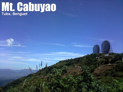
In nearby Mt. Cabuyao, just two kilometers away, two disc-shaped radiotransmitters were set up, comprising a famous landmark in Baguio City known as “Ra-dar”. Locals quip that these dishes are actually two giant electric fans that are responsible for Baguio’s refreshingly cool weather. At 2025 MASL, Mt. Cabuyao is also a great viewpoint, and is part of the trail going to the summit of Mt. Sto. Tomas. Cognizant of its strategic location, institutions ranging from the US Army decades ago to the television and cellphone companies of today have installed radio towers and transmitters in the area. Like Mt. Timbak (Singakalsa), Mt. Sto. Tomas is inhabited by locals; there are houses, schools, and vegetable patches. It is a quaint place whose bucolic air mingles with the modern feel of the towers.
The trail to Mts. Cabuyao and Sto. Tomas is easy. This can be modified to both extremes: some would even jog all the way from Burnham Park to the summit of Mt. Sto. Tomas, while others would take their vechicles through the rough road all the way up. Typically, however, hikers would take a jeepney or drive to Green Valley (passing by Marcos Highway), then walk the rough road ~5kms up to Mt. Cabuyao (there are shortcut trails, though). Atop Mt. Cabuyao, aside from the two dishes, attractions include the vegetable terraces and a view of Baguio City and the mountains on the central axis of the Cordilleras. Indeed, on a clear day, even along the trail, you can appreciate four of the five highest mountains in the Philippines, forming a line (from left: Singakalsa, Tabayoc, Panotoan, and Pulag). Then turning your eyes rightward would lead to Mt. Ugu (E). Also you can appreciate the landmarks of Baguio City, inlcuding the Philippine Military Academy, Loakan Airport, SM City Baguio, among others. There are stores serving cold drinks and snacks in Mt. Cabuyao. There are also some newly-constructed pilgrimage sites.
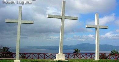
 From Mt. Cabuyao one can walk further up the road to reach Mt. Sto. Tomas. The road is easy follow, and if in doubt there are locals to query. The trail all the way to the summit is around 4kms long, and will only be steep in the final 20 minutes of ascent (entire leg takes around 1-1.5 hours). As you approach the peak you will see at least four ‘peaks’; the highest has the greatest concentration of towers, and the very top is marked by a cross with a ‘stained glass’ yellow-and-blue back (see picture). An inscription says Mt. Sto. Tomas is the highest ‘commutable’ peak in the Philippines. As in Mt. Cabuyao, the views are that of Baguio, the surrounding towns, and the mountains. Locals say that the best time of the day to be at Mt. Sto. Tomas is morning because clouds obscure the views in afternoon, even misleading some hikers because of the poor visibility. However, the chance of this happening is low since the road is wide and well-established.
Other, longer trails exist for both Mt. Cabuyao and mt. Sto. Tomas, and this destination is also perfect for mountain bikers who can actually bike all the way to the summit. Even tourists visiting Baguio City can check out this place for a refreshing view of Baguio City. Don’t forget to ask for the strawberries!
ITINERARY
(From Baguio City)
0600 Take jeepney or taxi to Green Valley
0630 ETA Green Valley; start trek
0830 Arrival at Mt. Cabuyao; picture taking
0900 Proceed to Mt. Sto. TOmas
1000 ETA Mt. Sto. Tomas summit; snacks
1030 Start descent
1300 Back at jump-off; return to Baguio City
1330 late lunch at Baguio City
SPECIAL CONCERNS
No permit is necessary for hiking in Mt. Sto. Tomas. If you are already in Baguio City, all you need to spend are your snacks and the jeepney fare to Green Valley (P12.50). Still, on a summer, apply sun protection since there is not much cover in the trails. During rainy season or rainy days, the roads get muddy and it might not be as enjoyable since the views would also be obscured. Hence summer is the best time to visit this destination.
It is possible to camp in the area although it is really best done as a daytrip, or a sidetrip in one of the major Cordillera climbs. Since it is a communications site, cellphone signal is strong throughout the trail.
Guides are not necessary in this trek. Turn right on the two junctions in the trail. If in doubt, just ask the locals. You may also want to hitch rides going up or down as several private vehicles take the road as well.
MT. STO TOMAS PICTURES

Towers line the trail from Mt. Cabuyao to Mt. Sto. Tomas. Take note of Mt. Sto. Tomas at the background, with its several peaks.

Mt. Cabuyao and its twin radars are about to be engulfed by clouds; picture taken along the trail up Mt. Sto. Tomas.
TRIVIA
Mt. Cabuyao is the perfect place to buy strawberries! Locals here plant the luscious berries without pesticides, and they sell it cheaper than the Baguio market princes. The blogger and his Outdoor Society companions munched on these fresh strawberries after their daytrip on April 18, 2008.
Leave a Reply
40 Comments on "Mt. Cabuyao (2,025 +) / Mt. Sto. Tomas (2,256 +)"
Kudos to you, sir gideon, for a very informative site. am from davao city but I consider my self also a cordilleran on the premise that we operate a transient house thus doing business there could be considered as one already base on the autonomous charter of CAR. anyway, have gone mt cabuyao on solo trek in the early 2010, it took me more than 2 hrs on easy walk.if you ask, what made me climb? to be honest it was plain
curiosity. however, that was the starting point that awakened my love for trekking, though i climbed mt masada in Israel before in1996(another curiosity that drove me while on a pilgrimage tour.)sad to say haven't been to the most talk about peaks of the land: mt apo & pulag, maybe my next target.
sa mountainside po ba ng mt. cabuyao maraming makikitang wild sunflower?
hello.. meron po ba kayong mga nakitang wild sunflower sa mountain side ng mt. cabuyao?
just got on the top of Mt.Sto Tomas where the tower of some communications erected… whoa… so amazing pero sobrang nakakatakot din…
I just descended sa twin mountain. Di ko nkita yung burial cave sayang. Nice weather today. Solo hike.