
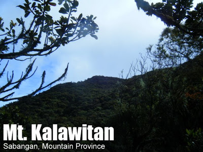
Mt. Kalawitan (2,714+)


MT. KALAWITAN
Sabangan, Mt. Province
Major jumpoff: Panorama Viewpoint, Halsema Hwy, Sabangan
LLA: 2714 MASL (#10/n)
Days required / Hours to summit: 2-3* days / 6-7 hours
Specs: Major, Difficulty 5/9, Trail class 2-4
BACKGROUND
Mt. Kalawitan (also called Calauit, Calawitan) is an undiscovered gem at the heart of the Cordilleras. It rises to a spectacular elevation of 2714 MASL, making it, in fact, the tenth highest mountain in the Philippines (displacing nearby Mt. Amuyao by a lead of just 12 meters). The name Kalawitan (name and spelling preferred by the locals themselves) may have been derived from the Kankaney word ‘kalawit’, which means ‘to climb’. An alternative etymology is mentioned in the ‘Trivia’ section.
There were discrepancies with Kalawitan’s elevation in the past, and PinoyMountaineer did not accept its NAMRIA elevation of 2714 when the List of Highest Mountains was prepared in 2009. However, recent GPS data, as well as data from other sources, seem to corroborate the more-than-2700 altitude of Kalawitan and for the next , Kalawitan will likely be listed as the tenth highest mountain in the Philippines, and the fourth highest mountain in Luzon.
Certainly, a high mountain such as Kalawitan will invite interest among hiking enthusiasts. In fact, there have been explorations in the past, notably by the First Philippine Everest Expedition Team, who climbed it as part of their training. One of the FPMEE members (and the latest Filipino to have climbed Everest), Regie Pablo, was actually the one who first pointed out that Kalawitan was higher than initialy conjectured. The late Jay Lorenzo of PALMC likewise expressed interest. However, most efforts to climb Kaliwatan (and thereby establish it as a regular hiking destination) was thwarted by the threat of hunter traps which were said to litter the trails.
In 2010, however, this situation changed with the training of guides. These guides were hunters themselves in the past, and were therefore familiar with the trails. Eventually, the hunters of Sabangan were convinced to avoid the trail leading up the summit when setting up their traps for wild boar and deer. With these developments, and through the efforts of Rolf Boller, a Swiss volunteer in Sabagan, a regular guiding service to Mt. Kalawitan’s summit was established. Apa campsite, a refuge of the locals during the war, was also established as the gateway to the summit trail, and in itself a pleasant retreat and campsite. Several groups, coming mostly from Switzerland and the Philippines, were able to reach the summit of Kalawitan in 2010. The blogger himself has climbed Kalawitan, having joined a group from Switzerland from January 10-12, 2011 and this article was created (is being created) in Apa campsite.
From Apa campsite, the 1500 meter vertical distance to the summit can roughly be divided into three. The first 500 meters consists of a pleasant forest – the Asoan Pine Forest – with a steepness somewhat reminiscent of Pulag’s Akiki Trail. Past the pine forest, the hiker enters a mossy forest which, although actually culminating at the summit, is terminated at 2200 MASL by a patch of pine trees. In this patch, Halsema Highroad begins to be visible on the right (if on the way to the summit), as well as Tirad Peak and Tirad Pass: it is view of the Western border of the Cordilleras and Ilocos Sur behind it.
The density of moss increases, and the trail also gets somewhat steep (again) in the final leg leading to the summit. Although the summit itself is quite unremarkable and is surrounded with trees, there is a patch of dwarf bamboo that actually serves as the summit landmark. This time, a view of Hungduan, Tinoc, and some other parts of Ifugao may be seen.
ITINERARY
Day 1
0000 Take bus from Manila to Baguio City
0615 Take first trip Baguio to Sagada at Dangwa Station
1100 Arrival at Panorama Viewpoint. Lunch.
1230 Start trek
1300 ETA Chico River
1400 Arrival at Apa Campsite
1500 Explore nearby rivers
1800 Dinner / Bonfire / Socials
Day 2
0500 Wake up call
0600 Start trek
0800 ETA Hunters’ Camp (1950 MASL)
0900 ETA 2200MASL
1100 Arrival at summit. Explore dwarf bamboo forest / swamps
1200 Lunch
1300 Start descent
1700 Back in Apa campsite
1800 Dinner / Bonfire / Socials
Day 3
0500 Wake up call
0600 Head back to Panorama Viewpoint
0730 ETA Panorama Viewpoint. End of trek.
1000 Take bus to Sagada, Bontoc, or Baguio en route to Manila
SPECIAL CONCERNS
Climbing notes. Hunter traps, although no longer found in the trail, still exist off-trail. Thus, do not deviate from the trail, and be mindful of warning signs. A horizontal block of wood, wedged into a tree, indicates a nearby trap in a direction perpendicular to the long axis of the wood.
Biology. Nik-nik and a variety of insects (called ‘tumul’) can be a big nuisance at the Apa campsite. Prepare to be a walking feast for the insects unless you bring insect repellent! Also, giant spiders live in the hunters’ huts so you may want to inspect the rooms first before you let your arachnophobic friend inside! Limatiks are present from 1700 to 2200 MASL.


A possible prospect in the future is a Mt. Kalawitan traverse. From the dwarf bamboo forest, a trail is said to exist leading to Hungduan, Ifugao. If true, Mt. Kalawitan will truly be a parallel of neighboring Mt. Amuyao which also has a traverse to Ifugao.
Leave a Reply
21 Comments on "Mt. Kalawitan (2,714+)"
yes we've been there too last year of November via Bayyo trek. and half the trek is full of leech (the mossy forest part). hehehe
We've been to Mt. kalawitan but the trek that we followed was via bayyo, bontoc, Mt. Province which i believe more adventurous trek going to Mt. Kalawitan. From Bayyo- Mt. Kalawitan is 7-8 hours walk straight without rest but if with rest time it will take 2-3 days..
Sir Gideon,
Good day.
Bakit poh per pax naman na ang singil sa Mt. Kalawitan at nasa 2,000php per pax.
With that price, iilan na lang poh ang makakapunta doon.
Thanks,
Gerald
to those who have been to Mt Kalawitan,
did you encounter any limatiks?
thanks!
correction lang po, no parts of mt. kalawitan belongs to hungduan, ifugao and bauko, mt. province.mt. kalawitan belongs to sabangan and bay-yo, bontoc, mt. province.