
Invitation to Ilocos #9: The quest for the real Mt. Linao


PinoyMountaineer presents “Invitation to Ilocos”, featuring the newly-documented mountaineering destinations of Ilocandia. This column is by Agnes Fidelis Gloria-Pinzon, PinoyMountaineer correspondent forNorthern Luzon and the One Degree Mountaineering Group.
Where is the true peak of Mt. Linao? We started asking this question after having descended from our first climb up the pristine Lake Linao in Adams two years ago, while plotting tracks for documentation. Lake Linao sits at 916 masl, 5.39 kilometers north of a peak identified in topographic maps as Mt. Linao. Local guides and community folk know very little about the mysterious peak that even hunters do not venture to. Why is Lake Linao so far from its mountain namesake? Adams’ municipal topographic maps as well as our own research of satellite pictures from Google Earth both reveal this mystery that has disturbed and puzzled ODMG since that first Linao trek. And yet, closer scrutiny of maps and satellite pictures reveal another excitingly confusing feature of the thick virgin mountainous region of Adams, there is another lake – deeper inside the ranges and sitting at the shoulder of Mt. Linao. Is this the real Linao Lake?
Seeking the answer to this riddle is the motivation behind ODMG’s first major exploratory trek for 2011. Coincidentally, our good friend, the absolute mountaineering authority Lester Susi, has also been curious about the true Mt. Linao and has even attempted a couple of explo climbs in the past to look for it so it made good sense to hook up for what looked like an authentic exploratory quest. Preparation entailed pouring over the maps, planning and re-planning trek routes as well as discussions on possible trail conditions. It was tedious and exhausting work which could very well be rendered useless once on the trail, as so many things can turn out differently but this kind of planning is indispensable in any exploratory attempt and to anticipate all kinds of scenarios is never without merit.
Our climb trio of Lester, Arch and I took off for Adams on May 14, 2011, a cloudy Saturday. Since our last climb to Linao, dirt roads have been carved on the mountainside that snaked as far as Apayao. These roads however were still narrow, loose and crumbling; passable only to bikes and single motorbikes. The new roads allowed us to take habal-habals to the sitio of Masasabog, the jump-off for a trek to Lake Linao which would have taken us 2-3 hours on foot.

From Masasabog, however, we continued on to Sitio Bucarot, Adams’ farthest community and a good 2 hour trek away. It started raining heavily at this point but since we were still trekking on the dirt road, it was fairly straightforward albeit very long. We stayed off boredom by speculating on limatik populations in the slopes of the true Mt.Linao as we recalled how vicious the limatik attacks were on Linao Lake! More seriously though, we were also made aware of another mining exploration attempt currently underway in Adams and how local communities were mostly against the incursion since they’ve been made aware of the irreversible destructive effects of mining on the environment and their way of life.
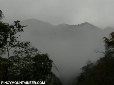
From Bucarot, where we picked up our third guide, Tata Rudolfo, we trekked for another two hours following the river. Before reaching the river though, we hiked along narrow foot ledges and cliffs that were mostly loose soil and gravel looking down on dizzying drops of more than a hundred feet high! It was a good thing that the rain drizzled out. That and the sight of the lush, thick vegetation and towering tree tops on the mountain walls around us proved calming enough! We even caught sight of an enormous hornbill that had bright scarlet plumage and a colorful beak! Too bad, our fellow Sicapoo explorer and birding enthusiast, Cecil Morella missed this trek. Tata Dolfo tells us that the Kalaw (Philippine hornbill) was common in these parts that they even nicknamed the river Kalaw. After a few minutes, we reached the river and trekked up and down the boulders, crossing and re-crossing the waters on several points. As the sky darkened with the setting sun, we set camp for the day on a high embankment that was close to a fresh water stream and called it a day.

Day 2 was bright and hot even in the few short hours before dawn. After breaking camp, Arch and Lester hunched down over their maps and GPS to establish our location and determine direction and target points. Yesterday, we learned of the other lake’s name, Lake Bulaoan and were told that indeed, it sat at the shoulder of Mt. Linao thus, that became out first destination goal. We continued on trekking up the river and then made our way further up through the gushing stream beds. There was a species of poison ivy along the trails that Lester had unfortunately somehow grazed and caused him acute pain spasms along his exposed calves. Our guides tell us that such kinds of plants and even more dangerous ones abound in the area, especially near the water. We trekked on more carefully after that, heedful of our guides’ warnings but we were lucky since the trail was still relatively wide since we were following water ways. We reach the mysterious hidden lake Buloaoan five hours after we left our river camp.
The entrance to which was marked by a gigantic boulder that blocked its view from the trail, so much so that the clearing and the astounding sight catches one by surprise and literally takes your breath away. It sat on a low small saddle and was completely surrounded by mountains. Smaller in comparison to the known Lake Linao, this lake was more rounded in shape and completely land locked, like a small Lake Venado. But what could very well be its rare jewel, was a tree that grew on an outcropping in the far middle of it, like a miniature deserted island in the middle of the sea. While the island tree was tall, it stood bonsai-like, almost ancient in appearance with outstretched boughs twisted by wind and rain, carved and marked with the passing of time. It was hauntingly beautiful and we stood there for a good few minutes taking it all in, oblivious of the drenching rain and the rumbling of thunder overhead. There was only one thing that broke our hearts, the lake was dry! We would need to go back to see it sometime in July when the abundant torrential rains would have filled it up. We decided to rest right there by the lakeside, wait out the rain and take lunch. From where we were beside the lake, we could see the steep sloping ridge that should lead up to the very tip of Mt. Linao, we would just need to figure out how to reach it.

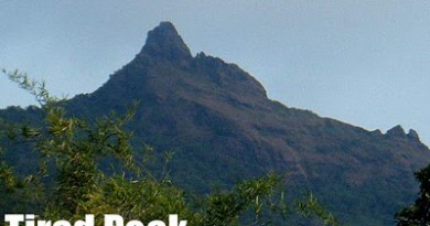
Adams’ terrain is almost entirely very thick tropical forest and deep in the ranges as we were, the vegetation cover was heavy and dense. To hack our way up through all that bramble, thicket and brush would prove to be the hardest part of the trek that day. We depended on our guides to hack a path through and up towards the summit and after nearly two hours, we eventually reach the ridge that led to it. We were surprised though to discover a hunter’s path that ran almost perpendicular to the way we came from the lake and tata Dolfo speculated that it must be the trail used by hunters from Tanglagan, Cagayan. Across and down the ridge lay Vintar, separated from this part of Adams by the wide expanse of the Vintar River. A few minutes ascending up the hunter trail then venturing outside it when it started veering down, we finally reach the much coveted peak of the enigmatic Mt. Linao at 1484 masl! The rush of feelings and emotions at reaching an unknown mountaintop for the very first time is pure exhilaration! A summit experience is common to most mountaineers who struggle against fear and difficulty to make it up to the top of a mountain – it is for this very experience that most of us climb in the first place – but the triumph of a first ascent is indescribable. It takes a different kind of courage to venture beyond where none have gone before.
Buoyed by the intensely happy sentiments, we settled in for the night as Arch and Lester planned for the next day’s hike. The plan was to open up a traverse trail on the ridges that would take us back directly to the area of Sitio Masasabog and closer to Adams’ poblacion. They decided on specific locations on the map called waypoints by exact coordinates that spanned the entire desired route from the summit all the way to our destination then using GPS directions as well as actual, manual mapping, we would just need to make our way from one point to another; like doing a dot to dot puzzle on foot in rough, rugged terrain. It sounded easy enough as we talked about it over a celebratory dinner. Our hopes were high and our hearts were warm as we snuggled in our tents, despite temperatures that dipped to a low 18 degrees.

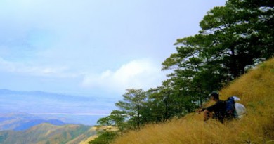
We started day 3 in very high spirits and after a quick breakfast we were off in a near jog along the ridge. We saw and followed the hunter trail again, noting traps and even a half-eaten wild boar carcass caught in one. When the trail abruptly stopped, our guides resumed hacking and clearing a path slowly, almost foot by foot. Very often, Arch and Lester would stop and consult the map, bring out the compass and compare GPS readings to make sure where we were and if we were still going where we ought to. It was painstaking and confusing, especially for me, so I left the two to their devices and mostly trudged on between them in increasing sullen silence as the day wore on. The trek was laborious because there was absolutely no trail and not only did we need to squeeze ourselves in through the thick undergrowth, we were mostly walking on loose gravel and soil that crumbled under our feet and gave way with the slightest of tugs.
Handholds and footholds were unstable and shaky and negotiating ledges required hugging the cliff walls or scrambling on hands, feet and knees. By mid-day we were ready to accept that we were nowhere near even the first waypoint and we were actually following Mt. Linao’s contour in a wide circle. While Arch and Lester quickly adjusted targets and goals, the first traces of frustration and doubt in my mind started. I wondered if we could make it home by the next day, our supposed last day. Arch reassuringly reminded me that the uncertainty is part of exploration and that while we weren’t lost, knowing where we were and where we wanted to go is entirely different from actually getting there. We huddled in a gully made by a dried creek bed for the night, flanked by almost eroding earthen rock and soil, silently praying that it wouldn’t rain. I tried to remain cheerful as I chased sleep while trying to keep the rising feelings of sinking dread and fear at bay.
Over breakfast the next day, we tried to assess our situation and manage expectations. We agreed that while our destination waypoints and targets were clear, the heavy foliage was making it very difficult to keep on going towards the desired destination. While the hacking would start in the right direction, it would almost always veer off towards a different one and this is how we lost our way for the most parts of the previous day. It was also very difficult to sustain motivation in our guides who struggled with the uncertainty of a new trail and who were so used to making their way towards the river. Arch and Lester doggedly decide to persist with the plan of traversing through the ridges and hopefully finding the ridge that would take us straight towards the river that landed smack beside sitio Masasabog. By lunch, we happily realized that at last, we were finally trekking away from Mt. Linao (though we nearly went a full 360 degree circle around it!) and inching our way towards our targeted ridge. But Tata Dolfo informs us that to trek that way would mean staying one more night on the mountains. He instead suggested a different ridge that would take us around and past Lake Bulaoan to end up on a creek trail that terminated exactly where we camped on Day 1 by the river bed. After recognizing the dangers of a night trek through the narrow foot trails and cliffs along the river trail, Arch decides to follow the suggested path but impressed upon Lester and me that speed is of the essence at that point. We could make it before night fall but only if we hurry. Indeed, hope is a remarkable thing that gives speed and strength to even the very weary. So we set out on a run, not very far from the image of Aragorn, Legolas and Gimli sprinting through the plains of Rohan, running like we were chasing Saruman’s Orcs! We make the descent to the river camp in 3 hours, huffing and puffing and skidding through loose rock, soil and rotten leaves like we were on a trail running race.

Knowing that we merely had an hour to go before we touched down in Bucarot where we could get in touch with our habal-habal transports, we took a long restful break, brewed some coffee, shared the last of our trail food and even washed off some of the four days of mud and dirt that still clung to us.
We finally reached Bucarot at 5:30 pm and learned that cellphone signal was intermittent in the sitio so we decide to continue the final march all the way to Masasabog. A few hours later, as we sat collapsed in exhaustion by the road side waiting for the motorbikes, we watched the full moon rise and crest above the mountain ridges, lighting up the cloudless evening sky. With numb and aching limbs but with full hearts we continued to stare up at the heavens, counting ourselves blessed.
Photo credits: Lester Susi, Agnes and Archie Pinzon

Leave a Reply
4 Comments on "Invitation to Ilocos #9: The quest for the real Mt. Linao"
@ Ma'am Agnes of ODMG
Thank you very much Ma'am. ODMG's efforts and aims serve as inspirations to us. I've read a lot about Ilocos mountains and got a chance to climbed with one of Ilocos mountaineering groups (Sokisok Mountaineering Club). They told me stories about their climbs on Ilocos mountains and indeed, it amazed me a lot because the way they illustrated the views and their climbs to me are far beyond what I've already saw and experienced in other Luzon mountains. Their pictures and yours as well re: Ilocos mountains are evidences and make me envy you guys..:).. Praying that your efforts will be truly blessed with what you want to achieve. God bless..
-Cory
@Cory,
Thank you for the kind words of support. Your words serve as a validation of ODMG's efforts to explore and open up new mountaineering destinations here in the North so that more people will be able to witness and appreciate the beauty of our peaks. Indeed, the mountains of ADAMS are truly virginal and so untouched that to go there and savor it becomes a truly blessed experience. ODMG hopes to contribute to efforts of the local government to preserve it and keep it that way. Doc Gideon is a valued friend and ally in the team's advocacy and we are truly grateful for his help and support. We wish you luck as well in your exploratory plans for your locality and we look forward to one day meeting you and your group along the trails! Kindred spirits are never too far apart. Agyaman kami apo.
@BPS, awaiting the day po… just let us know. Parang matagal na nating plano. 😀
@Gid, again, our appreciation and gratitude is boundless. Can't wait to have you back here.
/Aggie for ODMG
congrats again to ODMG… hope to revisit Ilocos Norte in the near future. =D
BPS
Kudos to ODMG! I'm a fan of your group. Reading your adventures from this site of Sir Gid makes me proud that a group introduces new but unspoiled places in the north. This manifests, among others, that there are still places, though not regularly visited, safe for hiking and rich with fauna and flora.Hope this will not be destroyed. There was a time when I am hesitant to explore mountains in my home province up north because of reports re: insurgents but reading articles about your climb gives me hope. Now, we are on the planning stage to explore mountains in Pangasinan and be able to share our adventures.:). God bless your group. Hope to see your group on the trails of Ilocos mountains..:).. Thank you Sir Gid for sharing this.:)
-Cory