
Mt. Patukan/Mt. Mating-oy Dinayao (1,906+)

 MT. PATUKAN/MT. MATING-OY DINAYAO
Kalinga Province
Major jump-off: Se-et, Tanudan, Kalinga
LLA: 17.28 N; 121.2 E; 1906 MASL (+1400)
Days required / Hours to summit: 7 days / 14-20 hours
Specs: Major Climb, Difficulty 9/9, Trail Class 6
BACKGROUND
A novel and extremely challenging hiking destination is Mt. Patukan in the province of Kalinga. It is so new that there are no established trails and the pioneering climbers only rely on hunter footpaths; it is so challenging that the trip requires a whole week, and entails crossing ravines, descending in steep slippery rocks, trekking rivers at night, and using ropes to negotiate some parts of the trail. The typical hike would also require crossing nearby peaks, such as Mt. Tangob and Mt. Kokok.
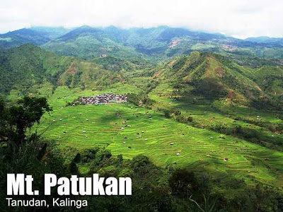
 The environment is comprised of dense, mossy jungles, where animals such as wild boars and deer roam, and where limatik (blood leeches) are a constant menace. However, the trails are pristine and enchanting: it is like going back to the prehistoric world…and the numerous obstacles to hurdle in the trail makes it a truly epic adventure. Aside from the fantastic trails, another remarkable feature is the breathtaking U-Ud ng Gappo waterfalls, with an estimated height of 120 meters. Rappelling down this falls is one of the highlights of the trek. The summit of Mt. Patukan is a rock with a small cave. Here, the views comprise of the mountains of Tinglayan (W), Tanudan (E), the rest of Kalinga (N), as well as the Bangad rice terraces (W).
The weather is so extreme that jump-offs vary depending on the time of year. During the dry season, it can be accessed via Mt. Tatakkan overlooking the Lubo rice terraces in Tanudan. However, during the rainy season it is safer to climb via Brgy. Se-et, also in the town of Tanduan. Flashfloods are common occurrences. Even more difficult traverse routes originate from (1) Bangad in Tinglayan town; (2) Mt. Lupting in Brgy. Ga-ang, Tanudan town, and (3) via Mt. Gappo River.
Mt. Patukan is rich in both legend and culture. The mountain is considered the forehead of what is known as the “Sleeping Beauty”, a mountain range in the Kalinga province so colorfully named as such. It was the Lubo tribes that christened the mountain as ‘Patukan’; these Lubo tribesmen are known for their hospitality. Strangers in their land are considered as their guests, and you can stay at the house of a bodong holder, or the barangay captain or anybody’s house. You will be considered one of the tribes once you are under their territorial land, anything that happens to you is their responsibility.
Meanwhile, on the other side of the mountain, the equally-friendly natives of Tinglayan town call the mountain ‘Mt. Mating-oy Dinayao’. A beautiful, romantic tale is behind this name: Once upon a time in the village of Dacalan, there lived a beautiful maiden named Dinayao. The exceeding charm and virtues of the young lady reached the ears of Binsay, a dashing and charismatic lad of Luplupa Tinglayan. So he traveled to Dacalan to see Dinayao. They fell in love at first sight; Binsay promised Dinayao that he will return at meet her at the summit of Mt. Patukan. However, when he returns home, he found out that his tribe is preparing for an imminent invasion of the village by warriors of another tribe. On the day that Binsay and Dinayao were supposed to meet at the summit of Mt. Patukan, a fierce battle took place in Binsay’s village and he had to help defend his tribe. Meanwhile, at the summit of the mountain, Dinayao is very eager to wait for Binsay. But instead of seeing her lover, it was Binsay’s brother who arrived, and he tells her that Binsay have been killed in the battle. Dinayao decided to stay in the mountain, he vowed to take her love till death to Binsay, so she lay down at the summit until her death. Perhaps she is the ‘Sleeping Beauty’ that forever dreams of the memory of her beloved Binsay.
This legendary mountain has only begun to be discovered, thanks to the pioneering efforts of Sir Nathaniel Dalanao and the group he formed, the Kalinga Mountaineering Society. He is the source of information for this article.
ITINERARY
(via Lubo Tanudan Trail)
Day 0
1800-2100 ETD for Tabuk City via Autobus or Victory Liner (P565) 12 hours journey by bus
Day 1
0900 Breakfast/rest
1200 Lunch
1300 Secure guides / Register/Prepare
1800 Dinner / socials
Day 2
0600 Wake-up call
0700 Board a 6×6 truck to Se-et, Tanudan (P200/person)
0830 Enjoy the ruggedness of the road
1200 Lunch at Jump off Site
1300 Assault to Mt. Tangob
1630 Descend From Mt. Kokok to Base Camp
1800 ETA Mt. Patukan Base Camp
1830 Set up camp; dinner
Day 3
0530 Await the sunrise; prepare for breakfast and departure
0700 Start Summit assault via Lubo Trail
1130 Early lunch along trail (First water Source along the trail)
1800 ETA Summit of Mt. Patukan
1900 Dinner/ socials
Day 4
0530 Await the sunrise; prepare for breakfast and descend
0700 Start descend
1130 Early lunch along trail (Hunters Cave)
1400 Start descend over a waterfalls approximately 60 degrees 120meters high(rope and system required i.e harness, carab etc.)
1600 Start descends from the top of a rock slope approximately 60 degrees 180 meters high. (rope and system required i.e harness, carab etc)
1800 ETA Base of the slope/ ETA Gappo river/prepare for dinner
1830 Dinner/ prepare for night river trekking
1900 Night River trekking/stone jumping
2400 ETA Lubo Village
0100 ETA Base Camp/ Set Camp
0130 Late Sleep
Day 5
(reserve day just in case the itinerary could not be followed; this day can also be spent with the friendly locals who will welcome you as their guest and visitors. Immerse yourself in their way of life!)
Day 6
0600 wake up call
0700 Prepare to Move /Assault to Mt. Kokok
1200 Lunch along the trail
1600 ETA jump-off site
1700 Take a 6×6 truck ride Back to Tabuk City
2100 ETA Tabuk City
2130 Dinner/ Socials
Day 7
0800 Breakfast
0900 Souvenir shopping
1200 Lunch
1600 Return to Manila/ Baguio via Autobus/ Victory Liner/ Gl Trans/ Dangwa Tranco
SPECIAL CONCERNS
Before attempting to climb this mountain, please contact the Kalinga Mountaineering Society first, so they can also help you secure companions or guides. Sir Nats Dalanao can be reached at +639216023500; you can also visit the Society at Purok 5, Bulanao Tabuk City Kalinga.
The province of Kalinga can be accessed by night trips serviced by Victory Liner and Autobus to Tabuk (P565 as of Nov. 2007). From there, you can meet with Kalinga mountaineers, and/or jeeps can take you to the jump-off.
On the trail itself, you will encounter Lubo tribesmen. It is customary for them to bear firearms; this is part of their culture and should not intimidate/scare off mountaineers. All people there are responsible with their guns, so don’t be surprised when you see them. Of course, it is still important to have locals with you. Languages spoken in the area are Kalinga, Ilokano, and Tagalog.
Some parts of the trail become very dangerous during the rainy season. For instance, it is very dangerous to set up emergency camp along Gappo River due to flashfloods, which can be triggered even by a small volume of rain. Take very important note of this fact. Also, bringing ropes and other assisted-climbing equipment is essential. Campsites are present as mentioned the itinerary, including that in the small cave in the summit – which is good enough for around 20 persons.
Water sources do exist, including one 200m below the summit. However, bringing reserves of water is advised (10-20 L / group). Cellphone signal is limited; only Smart has signal in the summit.
The sheer difficulty and length of this trek makes it advisable only for climbers with sufficient experience in major climbs.
TRIVIA
The tribes of Mt. Patukan have their code of conduct, called the “By-Laws of the Bodong” You can read these laws by clicking this link KalingaTambayan.com.
Numerous tourist spots can be found within the province of Kalinga. For instance, there is the Palan-ah ocated at Tulgao West, Tinglayan. The name is derived from the native term “Pinalpallang-ah” which means chair. The falls spray down from approximately 100 meters above forming a pool where during a sunny day, one practically swims at the end of the rainbow. There are also historic spots, hot springs, rice terraces, and picturesque villages. For more information, refer to the Official Website of the Province of Kalinga.
WEATHER OUTLOOK: TANUDAN, KALINGA
PinoyMountaineer.com congratulates Sir Nataniel Dalanao, founder of the Kalinga Mountaineering Society, for his pioneering efforts in Mt. Patukan; and we thank him for sharing this captivating, challenging mountain with us! You may email him at [email protected].

Leave a Reply
14 Comments on "Mt. Patukan/Mt. Mating-oy Dinayao (1,906+)"
I don't think this is no longer 9/9 kasi may road na from Tabuk to Lubo eh unlike before you have to trek the two peaks 6-8hrs bago marating ang basecamp. last holy week kasi sumakay kami ng 6×6 up to Lubo then 45mins trek to village na lang. Electricity will reach the village by Sept. according kay sir Nats Dalanao of KMS and we saw the electricity line that was already in place.
kami ang unang unang grupo na kasama nila sir nats, anlupet sa accomodation at very safe ang lugar.. VIP! sana makabalik ulit kmi one of this days! -kasama mong payat na lead!
astig ang accomodation s kalinga! extreme at rack en roll!
sir GId..post nyo po Itenerary sa Kibungan Traverse sa Benguet – Ilocos – Whammer
nasan na po ang Mt. Binaratan?