
Mt. Ugo/Traverse (2,150+)


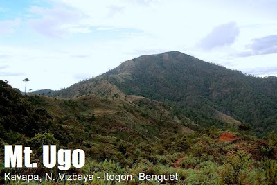
MT. UGO (2,150+)
Nueva Vizcaya and Benguet
Jump-off points: Kayapa, N. Vizcaya; Brgy. Tinongdan, Itogon, Benguet
LLA: 16.31916°N, 120.80166°E, 2130 MASL
Days required / hours to summit: 2-3 days, 9-10 hrs
Specs: Major climb, Difficulty 5/9, Trail Class 1-3
Features: Pine forests, highland villages, views of Cordillera peaks
LATEST UPDATES
BACKGROUND
Mt. Ugo (sometimes Ugu) is a major destination in the Cordilleras. Although its elevation is low compared to the lofty heights of Mt. Pulag and Mt. Napulauan, it has stately pine forests and spectacular views similar to its higher counterparts. Also, the traverse connecting N. Vizcaya and Benguet is a challenging trail that serves as the southeast entrance to the Cordillera mountain chain – opening possibilities such as a traverse to Mt. Pulag.
This mountain was “discovered” in the aftermath of a PAL aircraft crash on June 26, 1987. Flight PR206, a Hawker Siddeley HS-748, bound for Baguio, crashed in the slopes of Mt. Ugo while attempting to land in a monsoon, killing all 50 people onboard. Rescuers, including mountaineers, found the wreckage five hours after the crash, 200 yards below the summit. Subsequent operations paved the way for trails, and soon, word spread about a new hiking destination. Today, hundreds of climbers climb Mt. Ugu yearly; there is an established guide system, and the mountain is one of the more popular hikes in the Cordilleras, together with Mt. Pulag, Mt. Amuyao, and Mt. Napulauan.
Another plane was said to have crashed in the mountain during the 1960’s…ghost stories are often attributed to the victims of these crashes. Long before the age of airplanes, however, Mt. Ugu has been associated with danger. Jovanie Claver, writing in the provincial website of Benguet, explains that the name “Ugo” was derived from the Ibaloi word “Ugoan” which means “to cut the neck”. Oral tradition has it that Mt. Ugo was the site where the invading Spaniards were killed, in the fashion in which the mountain was named. Although with a somewhat violent etymology, Mt. Ugo can be seen as a monument to the fierce determination of its people to defend their freedom and way of life. In many ways, they have succeeded: until now mountaineers can have the experience of interacting with the locals’ unique culture. The villagers are very hospitable. They would even offer food — including their delicacy, goat meat.
 The Kayapa to Itogon traverse, pioneered by AMCI, is a 2- to 3-day trek. It begins at Kayapa proper. The first leg, requiring 4 hours, comprises of open trails with some pine trees and a steep latter part. It leads to Indupit village, where you can have lunch or stay overnight at the elementary school. Beyond the village, an hour of trekking will pass you by Mt. Samiento (1730 MASL) before reaching a major stopover, Domolpos village (4 hrs from Indupit). Here you can refill water being the last source before the summit. From Domolpos, the summit is just 2-2.5 hours away. The trails in this last leg are set first on pine forests, and then a brief stint on a mossy forest before reaching the summit (2130 MASL). A metal sign marks the summit, indicating that it’s within Brgy. Tinongdan, Itogon. The measurement is 2086 MASL although wide discrepancies exist.
At the summit, major Cordillera mountains can be seen as you face north: Mt. Singakalsa (N), Mt. Pulag (NNE), Mt. Tabayoc behind and beside it, among others. The other Benguet mountains NW may be obstructed and are too distant; Mt. Napalauan (NE) is eclipsed by Mt. Pulag. Prominent also is Mt. Sto. Tomas (W) and Baguio City. On a very clear day, a faint Mt. Arayat (S) can be seen. To orient yourself at the summit, the trail from Kayapa is NE; the trail to Itogon is W. The marker can be found at the south – where scenic views are also visible.
The return trip commences with a steep descent on pine forests, followed by rolling trails. First major landmark is the Old Sawmill, around 3.5 hours away. From there to Lusod village is another 30 minutes. Finally, the final 3-4 hours will take you to Itogon, and then to the barangay hall where a chartered jeepney can take you to Baguio City en route to Manila.
ITINERARY
KAYAPA-ITOGON TRAVERSE
(This is a reversible itinerary: you can choose to reverse the sequence of this itinerary for a Itogon-Kayapa traverse)
Day 0
2200 Assembly, Victory Liner GMA-Kamuning Station
2300 ETD for Bambang, Nueva Vizcaya via Isabela-bound bus
Day 1
0500 ETA Aritao or Bambang, Nueva Vizcaya,
0530 ETD for Kayapa, Nueva Vizcaya via rented jeepney
0700 ETA Kayapa, Register at police station, secure guides, breakfast
08000 Start Trek
1200 ETA Indupit Village / Lunch
1300 Resume trek to Domolpos
1700 ETA Domolpos Village. Stay in the Elementary School
0330 Wake up call, breakfast
0430 Commence final leg to summit
0700 ETA Mt. Ugo Summit (2150 MASL).
1300 Resume trek
1600 ETA Itogon Village; take pictures at Itogon bridge
1630 End of trek. Jeepney will be waiting past the river
TRAIL AND NAVIGATION MAP
SPECIAL CONCERNS
Active in promoting tourism and managing Mt. Ugu as a hiking destination is Ma’am Liza Diase, tourism officer of Itogon. She may be contacted through following numbers: +639167445628 or +639105482678. She can help you charter a jeepney and arrange guides.
A jeepney can fetch you in Lusod, on the waiting shed; however, if the roads are muddy during the rainy season, the jeep may not be able to go all the way to the end of the trail; you have to walk further down. Although there are steep parts, the trails of Mt. Ugo are generally benign. There are basic facilities in the villages (i.e. CRs, faucets) but electricity is non-existent in these distant parts. As for water sources, the villages have them but none in the summit. Cellphone signal is present in the summit and parts of the trail.
Cold weather is a concern but temperatures don’t go as low as those of Mt. Pulag or Mt. Amuyao.
THE GREAT CORDILLERA TRAVERSES
Mt. Amuyao Traverse
Mt. Napulauan Traverse
Mt. Ugo Traverse
TRIVIA
Iowak and Kalanguya tribes inhabit Mt. Ugo whereas Ibalois in general are the major ethnic group of Itogon. The main livelihood is mining; this is evidenced by the mines such as the Balatoc gold mines. Logging was also a major industry, nearby nearly denuding the mountain. The old saw mill is but a remnant of this past- in which, allegedly, cable systems transported wood down the mountain.
An interesting feature of the Mt. Ugo trails is the wooden gates that you have to open and close. Perhaps this has something to do with the cows which use the sloped grasslands as their grazing area.
Wild berries, called dusong (Vaccinium barandanum) grow in Mt. Ugo. More interestingly, a land crab (probably Cardisoma sp.) was spotted on the forests of Mt. Ugo! This was reported in 2007 by Sir Emman Palacio and his team. If confirmed, this is a great biological find!
WEATHER OUTLOOK: ITOGON, BENGUET
WEATHER OUTLOOK: KAYAPA, N. VIZCAYA
Leave a Reply
84 Comments on "Mt. Ugo/Traverse (2,150+)"
Hi. Would like to know if in Mt. Ugo they also have tents for rent like in Mt. Pulag? How much? Thanks.
At Tagpaya Campsite in Kibungan Circuit, we saw "Cardisoma"crab. We were wondering how does that crab managed to be in that place, but after reading this blog, i was surprised when I read that there's such a "Land Crab" in this region.
Hi everyone, we're going to hike Mt. Ugo this November 7-9, 2014. sa mga interested po, you can join our event:
https://www.facebook.com/events/773480002697612/?ref_dashboard_filter=upcoming
thanks!
Dear Friends:
The PCLCS in partnership with Barangay Dalupirip, Itogon, Benguet wish to invite you to the MT. PIGINGAN AMITY CLIMB at Dalupirip, Itogon, Benguet on April 25-27, 2014 at Dalupirip, Itogon, Benguet… come and let's enjoy and experience nature's wonder and serenity in the historical and legendary Dalupirip bastion.
The regform and IT are also downloadable at the PCLCS official website http://www.pclcs.com
For info on shared experiences about Mt. Pigingan, you may please refer to:
https://www.facebook.com/liza.gacoscosdiase/media_set?set=a.10150928769117206.438828.690732205&type=1
http://www.itogon.gov.ph/itogontimes/1st-mt-pigingan-executive-trek-a-success/
http://blogs.fanbox.com/SinglePost.aspx?pbid=2029242&post=2625585&mode&link=-1&page=-1&dt=010108&mlid=-1&vet=-1&src=-1&bts=2&fs=-1&apid=-1
ITINERARY
April 25, 2014 (Day 1)
2:00 PM – 5:00 PM – Assembly/Registration at DOT-CAR/Briefing
5:30 PM – ETD for Dalupirip, Itogon, Benguet
7:00 PM – ETA at Dalupirip/Set camp at Sapayan/Dinner/Campfire/Socials
10:00 PM – Lights out
April 26, 2014 (Day 2)
5:00 AM – Wake up call/break camp/prepare for ascend to Tivang
8:00 AM – Breakfast at Tivang
9:30 AM – Start ascend to Ambel-at Campsite/Lunch enroute
3:00 PM – ETA at Ambel-at/Set camp
5:00 PM – Sunset Viewing/Dinner/Campfire
April 27, 2014 (Day 3)
4:00 AM – Wake up call
5:00 AM – Ascend to Mt. Pigingan summit
6:00 AM – ETA at summit/Viewing: sunrise; Philex Dam 3; San Roque Dam; Pangasinan plains; Caraballo and Cordillera mountain ranges
7:30 AM – Back to campsite/break camp
8:30 AM – ETA @ campsite/ breakfast/ breakcamp
9:30 AM – Descend to Balococ
12:30 NN – Lunch at Balococ/Bathe
2:00 PM – Closing/Awarding program
4:00 PM – ETD for Baguio
Participation Fee: P1500.00 inclusive of Barangay Fee; T-shirt; ID; Certificate; Transpo (Baguio-Dalupirip-Back); Token; 2 meals (Dinner on 1st day; lunch on 3rd day)
WHAT TO BRING: Appropriate clothings (temp may range from 11°C – 14°C at night); camping equipment; trail/camp foods; proper backpacks; flashlights/head lamps with extra battery; drinking water/bottles/canteen cups; camera/binoculars (optional); proper footwear; first aid kit/medicines; rain gears (for unexpected afternoon showers/thunderstorms)
CONTACTS:
PCLCS Office Telefax: 074-422-4812
Oscar M. Camantiles – PCLCS Exec. Dir. (+639179372415; +639284003582)
Liza G. Diase – VP Fin/Exec Sec. (09483232958; 09276186068; 09328877358)
– Email: [email protected]; [email protected]
Jennifer Visaya (Optns. Mngr) – 09079848663
James Kidange (Asst. Exec. Dir) – 09289430895
Junie Parian (Documentation Spclst) – 09079793635
Steve Padsuyan (Office Attendant) – 09496169327
sir!,, what if i'll be the one who climb mt.Ugo without guide and regestration fee, accept ba?..