
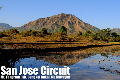
San Jose Circuit: Mt. Tangisan (491m), Mt. Bungkol Baka (617m), and Mt. Kawayan (595m)


SAN JOSE CIRCUIT: MTS. TANGISAN, BUNGKOL BAKA & KAWAYAN
San Jose, Tarlac
Major jumpoff: Sitio San Pedro, Brgy. Iba, San Jose
LLAD (T): 15°26’8.22″N, 120°23’47.63″E, 491 MASL, 4km
LLAD (BB): 15°24’44.74″N, 120°22’57.75″E, 617 MASL, 9.3km
LLAD (K): 15°24’24.83″N, 120°23’39.71″E, 595 MASL, 11.5km
Days required / Hours to peaks: 1-2 days / 1.5-2.5h (T); 4-6h (B); 5-7.5 (K)
Trail length: 17.7 kms (Loop: San Pedro-Tangisan-Bungkol Baka-Kawayan-San Pedro)
Specs: Major climb, Difficulty 6/9 (SJC dayhike), Trail class 1-3
Features: Scenic views of Central Luzon and Zambales mountains
Article history: Created February 10, 2013BACKGROUND
The western towns of Tarlac, particularly San Clemente, Mayantoc, and San Jose, are a fertile ground for hiking exploration and documentation, being located at the foothills of the Zambales mountain range. These towns are the access points to approach the Zambales mountains from the west, and the most notable of them (and the only one in common use today) is the well-received Mt. Tapulao Traverse. Moreover, there are also foothills that serve as hiking destinations in themselves. For instance, Mt. Damas, in San Clemente, Tarlac is becoming a popular hiking destination.Another such trek through the foothills is what I call the San Jose Circuit, which combines three small mountains: Mt. Tangisan, Mt. Bungkol Baka, and Mt. Kawayan, to form a very nice loop trail originating and ending in Sitio San Pedro, Brgy. Iba. The total trail length is around 17-18 kms. This hike features scenic views of the rural San Jose villages and fields, as well as rocky peaks that serve as viewpoints to the great mountains of Zambales, as well as the Central Luzon plains, where Mt. Arayat stands as a solitary giant.
Both Mt. Tangisan and Mt. Bungkol Baka have been climbed by hikers in the past decade, but usually as individual hikes. As early as 2008, Tarlac Mountaineering Club has shared a Mt. Bungkol Baka itinerary with PinoyMountaineer.com This article also provides information to do these mountains as separate hikes and is the successor article to the Bungkol Baka and Mt. Tangisan itineraries in the website. However, I will also be offering an itinerary that combines these two mountains, plus a third peak, Mt. Kawayan, for longer, more exciting trip that makes the trip from Manila well worth it. This can either be a long dayhike, or a more relaxed (but still challenging) overnight hike.
Most hikes in the Philippines are backtrails and traverses; I think we need more loop trails, where the trail is not repeated in most part of the hike (just like a traverse) but the entry and exit points are the same (just like a backtrail). The trail is one such trail, originating and terminating in Sitio San Pedro, Brgy. Iba, San Jose. What follows is a description of the trail. But first, check out this map to have an idea of the trail:
SAN JOSE CIRCUIT TRAIL MAP

TRAIL DESCRIPTION
Part 1: Sitio San Pedro to Mt. Tangisan (~4 kms). After walking through the vicinity of Sitio San Pedro, the trail quickly becomes moderately steep through the flanks of Mt. Tangisan, with a total vertical gain of around 370 meters. Environment consists mostly of shrubs and sparsely-distributed forest trees; it can feel very dry and hot especially during the summer months. As you go up the mountain, you will have a view of the scenic pond and ricefields (ESE). The trail will get steeper and less established as you reach the higher reaches of the mountain, and eventually you will reach the peaks of Tangisan. There are several peaks, with the highest reaching 491 MASL. Here, there are views of the rice fields and river in Brgy. Iba, as well as the surrounding peaks. The Zambales mountains, including Mt. Sawtooth and Mt. Tapulao lie west. If you are just doing Mt. Tangisan, you can just head back using this trail, completing an 8-kilometer hike that would take just 3-4 hours.
Part 2: Mt. Tangisan to Mt. Bungkol Baka (~5 km). From Mt. Tangisan, it is possible to follow the ridgeline of the peaks on a SSW direction and descend the mountain obliquely, losing about 300 meters of altitude, passing through a plantation of bananas, and reaching a clear stream, which can serve a water source and, if the trek is done as a dayhike, a convenient lunch or rest stop. From this stream, the trail meanders up the slopes between Mt. Bungkol Baka and Mt. Kawayan. The goal is to reach the ‘Junction’, a relatively flat patch surrounded by guava trees that is a. From here, you can assault Mt. Bungkol Baka. There are two peaks, an initial squarish peak that is essentially an imposing rocky outcrop reaching 551 MASL, and, optionally a round peak rising to 617 MASL, the highest point in the hike.
Part 3: Mt. Bungkol Baka to Mt. Kawayan (2 km). A very short section, this hike entails descending from Mt. Bungkol Baka back to the junction, then taking an oblique approach up Mt. Kawayan, ascending it from the not-so-steep southeast face. If you decided to skip the summit of Bungkol Baka, this is the highest point, reaching 595 MASL. Mt. Kawayan, being the southernmost of the three peaks, is a great viewpoint to see Central Luzon, particularly, Mt. Arayat (SE).
Part 4: Mt. Kawayan to Sitio San Pedro (~6 km). This downhill trail is quite steep and slippery initially, but becomes wider, gentler, and much easier as you continue your descent. Though the longest section of the trail, this is also the easiest, since it is almost entirely flat or descending. If in approaching Mt. Tangisan you were at the north of the pond, this time, you will approach the pond from the south, before reconnecting to the rough road the near the bridge in Sitio San Pedro, completing a loop of over 17 kms.
ITINERARIES
MT. TANGISAN DAYHIKE
Difficulty: 3/9
0300 Take any northbound bus from Manila that passes Tarlac City
0530 ETA Siesta Bus Terminal, Tarlac City. Breakfast
0630 Take rented jeepney to Brgy. Iba, San Jose, Tarlac
0730 ETA Brgy. Iba. Cross river / Trek to Sitio San Pedro
0800 Arrival at Sitio San Pedro. Secure guides.
0830 Start trekking
1100 ETA Mt. Tangisan summit. Early lunch.
1200 Start descent
1400 Back at Sitio San Pedro
1430 Back at Brgy. Iba. Tidy up
1500 Take rented jeep back to Tarlac City
1600 ETA Tarlac City / Take bus back to Manila
2000 Back in Manila
MT. BUNGKOL BAKA-MT. KAWAYAN DAYHIKE
Difficulty: 4/9
0300 Take any northbound bus from Manila that passes Tarlac City
0530 ETA Siesta Bus Terminal, Tarlac City. Breakfast
0630 Take rented jeepney to Brgy. Iba, San Jose, Tarlac
0730 ETA Brgy. Iba. Cross river / Trek to Sitio San Pedro
0800 Arrival at Sitio San Pedro. Secure guides.
0830 Start trekking
1115 ETA Junction
1145 ETA Bungkol Baka Peak 1 (551m)
1200 ETA Mt. Bungkol Baka summit*. Early lunch.
1300 Start descent
1500 ETA Mt. Kawayan summit
1530 Start descent
1730 Back in Sitio Iba / Tidy up
1830 Take rented jeep back to Tarlac City
1930 ETA Tarlac City / Dinner
2030 Take bus back to Manila
2330 Back in Manila
SAN JOSE CIRCUIT DAYHIKE
Difficulty: 6/9
0200 Take any northbound bus from Manila that passes Tarlac City
0430 ETA Siesta Bus Terminal, Tarlac City / Breakfast
0500 Take rented jeepney to Brgy. Iba, San Jose, Tarlac
0600 ETA Brgy. Iba. Cross river / Trek to Sitio San Pedro
0630 Arrival at Sitio San Pedro. Secure guides.
0700 Start trekking
0900 ETA Mt. Tangisan summit.
0930 Start descent via SSW face
1045 ETA water source / Early lunch
1130 Resume trek
1300 ETA Bayabas Junction
1330 ETA Mt. Bungkol Baka summit
1345 Head to Mt. Kawayan via Junction
1530 ETA Mt. Kawayan
1730 Back at Sitio San Pedro
1800 Back at Brgy. Iba /Tidy up
1900 Take rented jeep back to Tarlac City
2000 ETA Tarlac City / Dinner
2100 Take bus back to Manila
0000 Back in Manila
SAN JOSE CIRCUIT OVERNIGHT
Difficulty: 5/9
Day 1
0200 Take any northbound bus from Manila that passes Tarlac City
0430 ETA Siesta Bus Terminal, Tarlac City / Breakfast
0500 Take rented jeepney to Brgy. Iba, San Jose, Tarlac
0600 ETA Brgy. Iba. Cross river / Trek to Sitio San Pedro
0630 Arrival at Sitio San Pedro. Secure guides.
0700 Start trekking
1000 ETA Mt. Tangisan summit.
1030 Start descent via SSW face
1200 ETA water source (load up) / Lunch
1300 Resume trek
1530 ETA Bayabas Junction. Set up camp
1600 Assault Mt. Bungkol baka’s peaks
1730 Back to Junctton
1800 Dinner / socials
Day 2
0530 Optional sunrise hike up Mt. Bungkol Baka
0700 Breakfast / Break camp
0800 Start trek to Mt. Kawayan
0900 ETA Mt. Kawayan.
1000 Start descent
1200 ETA river (water source) / lunch
1300 Resume trek
1400 Back in Sitio San Pedro
1445 Back in Brgy. Iba / Tidy up
1700 Take rented jeep back to Tarlac City
1800 ETA Tarlac City / Dinner
1900 Take bus back to Manila
2200 Back in Manila
PRACTICALITIES
Getting there. Siesta Terminal in Tarlac City is a major terminal of northbound buses like Victory Liner. To get there, take any northbound (i.e. Baguio, Dagupan City) bus from Cubao or Pasay (~P200). From Tarlac City, rent a jeepney going to San Jose (P1500). It is also possible to take the regular jeepney from Tarlac.
Registration and guides. Guides may be secured at Sitio San Pedro for P350/day for an overnight hike; a two-day rate (P700) is collected for the full San Jose Circuit even if it is only done as a dayhike due to the effort involved; there are no registration fees as of February 2013. For assistance in doing the hike and transportation, you may coordinate with the GAME-NEST hiking club through Sir Eman Miclat (+639123517719).
Hiking notes. Tarlac mountains are characteristically hot and dry, especially during the summer months; prepare accordingly. From Brgy. Iba to Sitio San Pedro, you have to cross a river which can reach knee-deep or even waist-deep heights, depending on the season. You may want to wear sandals first before wearing shoes if you want to avoid getting your feet wet right at the start of the hike. Water levels may rise so be cautious.
Camping notes. I am imagining that the Bayabas Junction would be the best place to camp, since it would be cool during the evening, and although there is no water source, at least it is not as far from the water source as the peaks of either Bungkol Baka or Kawayan.
SAN JOSE CIRCUIT PICTURES
 |
| At one of the rocky peaks of Mt. Tangisan |
 |
| The beautiful pond surrounded by the three mountains. |
 |
| View of San Jose town from the summit of Mt. Tangisan |
 |
| Assaulting the rocky Peak 1 (551m) of Mt. Bungkol Baka |
 |
| The blogger with members of GAME-NEST, a Tarlac-based hiking club |
 |
| Mt. Arayat as viewed from Mt. Kawayan summit |
TRIVIA
Mts. Tangisan, Bungkol Baka, and Kawayan are within the homeland of the ethnic Abeling people — you will have a chance to interact with them for their men are the ones who serve as guides/porters for this trek. The Abeling are similar to the Aeta – but their hair are not curly, and they have sharper noses.
A predecessor article entitled “Mt. Bungkol Baka” was posted in PinoyMountaineer.com as early as 2008, based on information provided by the Tarlac Mountaineering Club, one of the pioneers in exploring the area. Among the (if not the) first hikers to climb up the peaks in San Jose are the UP Mountaineers.
ACKNOWLEDGMENTS
PinoyMountaineer thanks members of the GAME-NEST hiking club based in Tarlac City, Tarlac for accompanying him and his friends in the first San Jose Circuit dayhike on February 9, 2013. An account of this hike is narrated in Hiking matters #327.
Leave a Reply
3 Comments on "San Jose Circuit: Mt. Tangisan (491m), Mt. Bungkol Baka (617m), and Mt. Kawayan (595m)"
Thank you sir Eman and sir Israel of GAMENEST and to Vice & family for assisting us in our San Jose Circuit Dayhike last Saturday.
Also, thanks to our guide Sir Danny and to sir Johnny. It's a nice experience trekking the Tarlac Mountains. 🙂
@sir gid ..pwd b dian kht wla guide?
established b trail ? or mandatory ang guide?
@all , bka may aakyat dian hahahah
09465331573
Your photo captures was wonderful! I admire the serenity of Mt. Tangisan.