
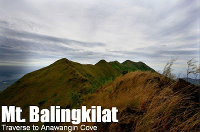
Mt. Balingkilat/Traverse to Anawangin Cove (1,100+)


MT. BALINGKILAT/TRAVERSE TO ANAWANGIN COVE
Subic, Zambales
Entry point: Sitio Cawag Settlement, Subic
Exit point: Anawangin Cove (Brgy. Pundaquit, San Antonio)
LLA: 14.89 N, 120.11 E (est.), 1100 MASL
Days required / Hours to summit: 2 days / 5 hours
Specs: Major climb, Difficulty 6/9, Trail class 1-3
 Information for this article was provided by the San Beda Mountaineering Society, recognized as the first recorded group to successfully complete the trek mentioned in this article on December 2008. Congratulations and many thanks!
An exciting new climb in Zambales, pioneered by the San Beda Mountaineering Society (SBMS) and the chosen Climb of the Month for January 2009, is a traverse from Mt. Balingkilat to Anawangin Cove, thereby connecting two famous destinations in the region, and creating a challenging two-day trek that combines elements of land and water. After a conventional trek Balingkilat, you will pass by the open, grassy highlands of Zambales – ridges that afford an excellent view of the coast – in the scenic Day 2 trek that will culminate in Anawangin Cove – in itself a sought-after destination for its unique landscape of volcanic white sands and pine trees.
From Anawangin, possibilities include Capones Island by boat or Mt. Pundaquit by foot – either way taking you to Brgy. Pundaquit in San Antonio.
The novelty of this climb, its ability to cover a lot of places and thus maximize a Zambales trip, and the beauty of the trail makes this climb a highly recommended trek in Central Luzon. For more information on Mt. Balingkilat and Anawangin Cove, check out their respective articles in PinoyMountaineer.
ITINERARY
San Beda Trail (2008)
Day 1
0300 Take Victory Liner bus from Pasay to Olongapo (P200+)
0600 ETA Olongapo City; breakfast.
0700 Take rented jeep to Sitio Cawag, Subic
0800 ETA jumpoff; secure guides
0830 Start trek
1230 Arrival at Kawayanan. Lunch.
1330 Resume trek
1700 Arrival at campsite; set-up camp
1800 Dinner / socials
Day 2
0430 wake up call/ bfast break camp
0600 Start trek
0615 Balingkilat summit
0630 Start traverse
0700 ETA St. Benedict’s Peak*
0745 ETA Pointed Peak
1000 ETA Emil’s Junction*
1100 ETA Mendiola Peak*
1230 Anawangin flat land; Lunch
0330 ETA Anawangin Cove. Beach / Unwind
*These are provisional names for landmarks as put forth by the SBMS.
From Anawangin Cove, you can have pumpboats to take you back to Brgy. Pundaquit late afternoon, or you can spend the night camping in the Cove, before heading back to Brgy. Pundaquit either by boat (passing by Capones Island) or by foot (traversing Mt. Pundaquit)
TRAVERSE TRAIL MAP
SPECIAL CONCERNS
The going to Balingkilat and going back from Anawangin part is easy (see “Special Concerns” sections of each article). The only uncertainty is the traverse. A GPS-guided trek is recommended until this trail is established.
MT. BALINGKILAT TRAVERSE TO ANAWANGIN PICTURES
The high peak at the background is Mt. Maubanan; Emil’s Junction is the fork between the path to this peak and the leftward, eastward continuation of the trail to Anawangin.

The open ridges towards Anawangin Cove face the coast and are very scenic.

The SBMS team with their banner during their pioneering climb in December 2008.
TRIVIA
The expedition that led to this itinerary was the Climb of the Month for January 2009.
The SBMS climbers who first did this climb are: John Buno, Lendl Layug, JR Yu, my good friend Coby Sarreal, Jose Victor Benedicto, Mike Arbues, Ace Borja, and John Vergara.
A parallel (though not geographically parallel) climb would be a Mt. Cinco Picos/Traverse to Silanguin Cove, and this has been described also in PinoyMountaineer.
Leave a Reply
29 Comments on "Mt. Balingkilat/Traverse to Anawangin Cove (1,100+)"
share ko lang
from sitio cawag to base camp ng balingkilat 8hrs may malapit na water source sa base camp 30mins lang kinuha ng guide namin sila na kumuha. tapos kinhua namin traverse sa anawangin cove ng 14.5hours, sobrang dehydrated kami. grabe almost 9hours walang tubig kasi sa anawangin na tlaga kinukuha ang water source.
ito naging itirenary namin
Day 1
10:OO jump off sitio cawag
11:00 start trek
13:00 kawayanan lunch(water source)
14:00 resume trek
18:30 base camp pitch tent
19:00 socials
20:00 lights off
Day 2
6:00 wake up breakfast( kuha na ng mdaming tubig kasi may water source malapit sa base camp.
8:00 summit Mt.balingkilat pictures
9:00 resume trek traverse to anawangin
14:00 lunch (ubos na water namin)
22:30 anawangin forest (flatland) still wala parin clean water source
23:30 ETA Anawangin cove/beach
nung nakarating kami sa anawangin may maliit na tindhaan ng softdrinks grabe naka ubos ako ng 1.5 na Sprite, dinner.
Day 3
1:30 AM boat to pundaquit
2:00 AM ligo( grabe ang iingay namin kami)
2:30 tricycle to san antonio
3:OO AM San antonio
5:00 ETA Olongapo
9:00 ETA Manila
yung iba di na nakapasok. grabe experience namin dito. pero enjoy!
Hi po, our group is planning a climb at mt. balingkilat/anawangin traverse, ano po ung mga updates sa guides/trails and kami po ba ung gagawa nung letter na "intent to climb"?? thanks in advance
We're planning to trek dis mountain on 2nd wik of feb.. Any updates for the guide fees and other matters? Tnx..
Anyone wants to do a Balglingkilat Anawangin Traverse? Lets DIY. Email me at davinci34@ymail.com. Chinese New Year weekend sana Jan 21 -23.
Is it open na ba? re:Advisory because of the rates being applied by the guides etc.
And ask ko lang sirs/ma'am if its possible for a Balingkilat Nagsasa Traverse. Thanks!
-Maj