
Mt. Talomo (2,674+) Traverse to Mt. Apo (2,956+)

 TALOMO-APO TRAVERSE
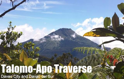
Davao City and Davao del Sur
Entry point: Purok 6, Tamayong, Calinan, Davao City
Exit point: Sitio Mainit, Brgy. Kapatagan, Digos, Davao del Sur
LLA (Talomo): 2674 MASL (#13)
LLA (Apo):: 7°0′30″N, 125°16′33″E, 2,956 MASL (#1)
Days required / Hours to summits: 4-7 days / 10-14 (T); 20-28h (A)
Specs: Major Climb, Difficulty 9/9, Trail class 2-5, Exploratory
Features: Mossy forests, Sulfuric vents, Lake Venado, Boulders
One of the Top 10 Climbs in the Philippines
Note: This itinerary is still under construction. Content will be expanded and modified in the future.
BACKGROUND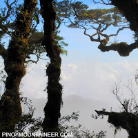
Doubtless one of the most exciting and challenging trails in the whole Philippines, the Talomo-Apo “Megatraverse” is the ultimate tropical hiking experience, enabling an immersion into a variety of environments that represent the beauty and diversity of Philippine mountains. It takes at least four days, with a daily average of 12-14 hours trekking time, to complete the traverse, with some parts of it steep and exploratory; a five, six, or even seven-day climb is recommended. These specifications give the Talomo-Apo Traverse a Difficulty 9/9 rating, making it one of the toughest climbs in the Philippines; definitely it is much tougher than a regular Apo Traverse, even if it is combined with a Talomo; the connecting route between Talomo and Apo provide much of the challenge. For the classic Talomo-Apo Traverse, the Kapatagan Trail is recommended, so that the hiker will never have to repeat any part of the trail (unlike if the Kidapawan Trail will be used, in which case the hiker has to return to Lake Venado using the same trail).

The rewards, however, are immense. In just one climb, one gets to bag two of the highest peaks in the Philippines, Mt. Apo the highest, and Mt. Talomo at least the 13th highest mountain in the Philippines (or possibly higher). Several types of forests are encountered: from the primeval grandeur of the upper montane (mossy) forest in Talomo’s summit to the stately grandeur of the century trees, bearded with lichens, of Mt. Apo. Finally, landmarks such as Lake Venado, the highest lake in the Philippines, and the vast Boulders are encountered, with sulfuric vents effusing steam beside it (beware of the fumes!). The summit itself, rocky and adorned with beautiful shrubs, has a very nice campsite and is an attraction in itself. From atop it, one can view many of the high mountains of Mindanao, and the sunrise is usually spectacular.
The Talomo-Apo “Megatraverse” is truly a wonderful journey and is highly recommended for adventure seekers who wish for a longer-than-usual, tougher-than-usual climb. The difficulty and beauty of this climb make it an unforgettable journey.
TRAIL DESCRIPTION: FOUR-DAY TALOMO-APO TRAVERSE
Note: We are describing the actual four-day climb that we did in October 2011; just use the information to fit your preferred timeframe for the climb.
Day 1: Up Mt. Talomo
The Megatraverse starts off at the Mt. Talomo jump-off at Purok 6, Barangay Tamayong in Calinan district, Davao City. From here, hikers will make their way through villages and banana plantations until they reach Mt. Sicao Village (named after the patriarch of the villagers), the last refuge before Mt. Talomo’s mossy forest. Here, there is a water source and an area where lunch/ packed dinner may be prepared.
Depending on the pace of the hikers, they may either summit Talomo and camp there or settle for Lumot campsite some 400m below the summit. Both will entail night trekking as Mt. Talomo in itself is already a 7/9 climb. A variation, however, is to camp at Sicao village on day 1 and assault Talomo on day 2, extending the trip but shortening the hiking time on each day.
Day 2: Talomo to Basinan campsite
On day 2, it’s an early start from Lumot campsite and assault Talomo arriving in the summit before noon. From here, the group will cross the ridgeline of Mt. Talomo and two more high points: Lipopocan Peak and Dalag Peak (both at 2650~2700MASL). Good views of the prominent, yet distant, Mt. Apo can be seen.
The group, hereon, will push for the Basinan Campsite somewhere in the dense jungles within the Mt. Apo National Park; again, night trekking is highly likely as the distance between Talomo and Basinan Campsite is lengthy. The trail is “insanely difficult”, sometimes effaced, often steep and slippery. Prepare some balancing acts on logs, scrambling on loose soil, and, as of 2011, and navigating through unfamiliar territory, as trails are not yet established. The final kilometer leading to the Basinan campsite, past the river, is particularly challenging.
Day 3: Basinan to Mt. Apo Summit campsie
The group will again start early for a lunchtime at Lake Venado- the familiar high lake of Mt. Apo. From Basinan to Lake Venado, except a few more “balancing acts” on logs and some steep parts, the trail is easier relative to the previous day.
At Lake Venado, hikers will get their much awaited close-up with the grandfather of Philippine Mountains, and perhaps unwind in the lake (there are no rules against swimming, but caution is recommended, and at times, the lake can get murky).
Past Lake Venado, the group will push for the summit campsite of Mt. Apo. Again, expect night trekking as the assault will take around 3-5 hours.
Day 4: Mt. Apo Summit to Kapatagan via Boulders
A quick assault from the campsite takes you the summit of Mt. Apo, the highest peak in the Philippines! This is a perfect spot for awaiting the sunrise and viewing the various peaks of Mindanao, including Talomo itself, the Bukidnon mountains, albeit faint; White Peak and the highlands of Compostela Valley and Davao Oriental; the conical Mt. Matutum, and at the foot of Apo, a round shaped Mt. Tampurong.
After breaking camp, the descending route is via the spectacular Boulders – a massive array of volcanic rocks, where the trail runs parallel to a crevice of sulfuric vents. Pray that the wind blows in the other direction, lest the noxious fumes irritate your lungs (cover your nose and mouth with a piece of cloth if it happens) – but don’t worry, there’s no long-term damage to a brief, acute exposure to this. Otherwise, enjoy one of the most famous trails in the country, down to the forests of Gudi-Gudi and then Kapatagan. It’s still a long way but a continuous descent should take you only until early evening at the latest. End of the Megatraverse!
ITINERARY
Day 0
Arrival in Davao City. Prepare logistics.
Day 1
0500 Early breakfast
0600 From Davao City, take jeep transport to Calinan
0700 ETA Calinan Public Market, take vehicle to jumpoff
0800 ETA jump-off (Purok 6,Tamayong)
0830 Start Trek
1000 ETA Mt. Sicao Village, Register, Prepare lunch
1300 Resume Trek
1600 ETA River
2000 ETA Lumot Campsite, Set-up camp
Day 2
0600 Early breakfast/ Break camp
0800 Start Summit Assault
1030 ETA Mt. Talomo Summit (2,674+ MASL)
1100 Start traverse
1700 ETA Cabacan River
2300 ETA Basinan Campsite, Set-up camp
Day 3
0600 Early Breakfast/ Break camp
0800 Start trek to Lake Venado
1200 ETA Lake Venado, prepare lunch, relax
1430 Start summit assault
1800 ETA Mt. Apo Summit Campsite, Set-up camp
Day 4
0520 Watch sunrise atop Mt. Apo Summit (2,956 MASL)
0700 Breakfast/break camp
0900 Descend via Boulders
1500 ETA Gudi-Gudi Campsite
2000 ETA Paradise Village
2200 ETA Digos City, camp or take forward trucker to Davao City
SPECIAL CONCERNS
Warning: This climb must only be attempted by serious and experienced hikers with a well-equipped team, ample supplies, and knowledge in first aid and safety (considering the distance of Basinan campsite to the nearest help). Moreover, this climb would entail either double-digit hiking hours per day and daily night trekking OR an almost week-long climb.
Itinerary notes. To reduce the number of hiking hours per day, this itinerary can be spread to 6 or more days depending on the interested group. The trail is overgrown and will require agility and flexibility to bend and twist with the branches, aside from endurance. Moreover, the trail can be dangerous with steep ascents and descents- rope and BMC knowledge is a must. Water sources are primarily rivers, so stock up when necessary. The majority of the climb will be at elevations greater than 2,000MASL so expect cool days and chilly nights.
Logistics. From Davao City, it is easy to head to Purok 6 of Brgy. Tamayong; options including taking a jeep to Calinan, then a habal-habal, or renting a jeepney all the way. Take note that at times, it is possible to take a habal-habal all the way to Sicao village. It is better if prior arrangements for return transportation to Davao be made via Kapatagan.
Guides. As of 2012, there is no central body that regulates permits in Mt. Apo; thus, one can simply go to the jumpoff of Mt. Talomo, pay the registration fee there. However, exiting at Kapatagan entails paying an exit fee at the gate (the advantage is that you theoretically should get a climb certificate from the tourism office of Digos). Guide fees may be higher than the regular Mt. Apo climb. For pre-arranged trips and guidance, contact info@pinoymountaineer.com
Hiking notes. Cellphone signal: Present in many parts of Mt. Apo, and also in Talomo summit, but there is a blind spot during the traverse between Talomo and Lake Venado. Basinan campsite is without signal. Campsites are small in the Talomo side, with the Talomo summit campsite able to fit 6-7 tents, and same thing for the Basinan campsite.
GPS DATA
PinoyMountaineer will be sharing the GPS data from the traverse soon.
TALOMO-APO TRAVERSE PICTURES AND VIDEOS
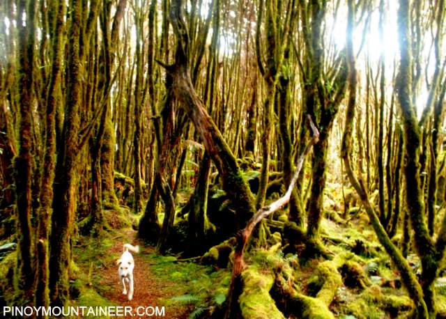
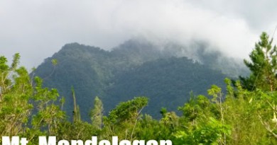
The mystical forest of Mt. Talomo is just the first of many captivating sights that await the trekker in the Megatraverse.

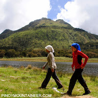
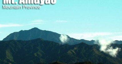
Mt. Apo, as viewed from the summit of Mt.Talomo

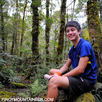
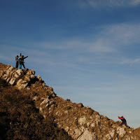
Initially, the traverse from Talomo passes across two other peaks and a scenic ridgeline. Javier Cang, in this picture, was a participant in the blogger’s Talomo-Apo climb and contributed in this itinerary.
Video: Crossing the logs en route to Basinan campsite (Day 2)
Video: Arriving at Lake Venado after a challenging traverse (Day 3)

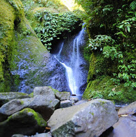
Lake Venado: photo taken from the slopes of Mt. Apo’s peak during the ascent to the campsite (Day 3).

Sunrise viewed from the summit of Mt. Apo, the highest point in the Philippines.


The high peaks of Mindanao are visible from the peaks of Mt. Apo, as seen in this collage.

Surveying the Boulders, with the sulfuric vents and steam running parallel to the trail.
TRIVIA
The basis of this itinerary is the blogger’s climb with his Malaysian friends led by Deeno Lot in October 2011, a climb that is described in Hiking matters #203-206 (see below).
This is the longest itinerary ever written in PinoyMountaineer, the first to include videos!
Leave a Reply
2 Comments on "Mt. Talomo (2,674+) Traverse to Mt. Apo (2,956+)"
Sir Gidz, share ko lang po ang aming experience sa talomo-apo traverse.
http://adayinthehike.blogspot.com/2013/01/talomo-apo-traverse-day-2.html
Thanks
kudos and congrats to the success of the megatraverse Sir Gid!
Can you provide your readers a breakdown of the expenses from registration fees/ guide fees/ transportation fees so that the readers can have a baseline from which to plan their itineraries.
Thanks