
Mt. Makiling/Sto. Tomas Trail (1,090+)

 MT. MAKILING (VIA STO. TOMAS)
Sto. Tomas, Batangas
Jump-off: Brgy. San Miguel, Sto. Tomas
LLA: 14.13°N 121.20°E, 1090 MASL (Peak 2)
Hours to Peak 2 / days required: 1-2 days / 7-8 hours
Specs: Major climb, Difficulty 6/9, Trail class 3 with roped segments
BACKGROUND
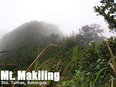
Much more challenging than the UPLB trail are the trails on the south face of Mt. Makiling, arising from Sto. Tomas, Batangas. The forests teem with limatik and poison ivy and the trails are labyrinthine, spawning a lot of entry and exit points. Moreover, the precarious location of the trails have taken its toll on climbers, causing injuries and even deaths in the past. These elements of danger must be considered by anyone who dare enter Makiling on this side. The rewards, of course, are great: after crossing this difficult trail, going down via UPLB is relatively pleasant, especially during the summer months. The sights along the way, especially in Haring Bato and later in Melkas Ridge, encompass much of Batangas province and the vicinity, including Mt. Maculot (S); Mt. Malipunyo (SE), and Mt. Banahaw (ESE).
‘Maktrav’ has become the nickname for the Makiling Traverse, and such is the itiner ary detailed here. It is commenced on plain ground of rural fields: patches or fields of bananas and corn, and segments of cogon grassland. PinoyMountaineer has isolated two major trail variants of the Sto. Tomas trail. The more often used is the west trail, which is more outlined in the internet as passing landmarks like the Palanggana campsite and peak. The other – the Sipit Trail, goes straight to the Melkas Ridge (Gubatan) campsite. The two have relatively similar time requirements. From the campsite, one will cross the Melkas Ridge itself – some of its parts have ropes to assist you since this is the most precarious part of the trip. At the end is Peak 3, from which another challenging part of the trek begins – the ‘ Wild Boar Trail’ which ultimately leads to Peak 2, or the summit of Mt. Makiling. From here is an easier, more familiar descent via the more commonly used UPLB trail.
After the UPLB trail was closed as an entry point in 2007, there has been renewed interest in the Sto. Tomas trails. An action-packed dayhike, traversing Mt. Makiling, is likewise gaining popularity. Considering the difficulty of carrying heavy packs across Makiling, a dayhike is a good option — and although there have been several failures in the past (including the blogger’s), it is worth a try.
ITINERARIES
Via Palanggana (West) Trail
0430 Assembly at LRT-Buendia, board any bus passing by Sto. Tomas (P84 01/2008)
0600 At Sto. Tomas market, rent jeep to jump-off.
0630 ETA jump-off (Brgy. San Miguel). Register (P20), then proceed to water source
0700 Start trek
1000 ETA Palanggana peak, snacks.
1130 ETA Melkas ridge campsite. Commence Melkas Ridge crossing.
1200 ETA Peak 3. Follow Wild Boar trail to Peak 2
1400 ETA Peak 2 (Mt. Makiling summit). Late lunch
1430 Start descent via UPLB trail
1800 ETA UP College of Forestry; walk down the road and wait for jeepney (P7)
1830 Dinner at Grove, Los Baños (many food options here)
1930 Head back to Los Baños Crossing, take Buendia or Cubao. (note: last trip for Buendia is 2030)
Via Sipit (East) Trail
0430 Assembly at LRT-Buendia, board bus passing by Sto. Tomas to KM. 64 (P87 01/2008)
0600 At KM. 64, take tricycle to ‘Bundok’ or ‘Mt. Makiling’ (left of highway).
0630 ETA jump-off. No registration required. Proceed to Resthouse
0700 ETA Resthouse
0730 ETA Station 1 then Station 2 (Kambigan)
0800 Find trail left of Rocky River
1030 Merge with main trail (marked with red and white ribbons). Follow it to the right (NE).
1100 ETA Melkas Ridge campsite. Snacks.
1130 Commence Melkas Ridge crossing
1200 ETA Peak 3. Follow Wild Boar trail to Peak 2
1400 ETA Peak 2 (Mt. Makiling summit). Late lunch
1430 Start descent via UPLB trail
1800 ETA UP College of Forestry; walk down the road and wait for jeepney (P7)
1830 Dinner at Grove, Los Baños (many food options here)
1930 Head back to Los Baños Crossing, take Buendia or Cubao. (last trip for Buendia is 2030)
Notes: (1) There is confusion as to where the real Haring Bato is — whether it is part of Melkas Ridge or down the line in the Palanggana (West) trail. (2) Gubatan campsite is assumed here to be the same as the Melkas Ridge campsite. (3) The clearing surrounded by cogon right after Melkas may very well be Peak 3, and perhaps this is also Mt. Cornites. Accounts in the internet are conflicting and PinoyMountaineer will update labels in this itinerary as soon as they are verified/rectified.
SPECIAL CONCERNS
The full establishment of the Sto. Tomas trails have yet to come; as of Jan. 2008 the trails are still in poor shape and there are many reports of getting waylaid along the way. Others may attribute their experiences to spirits dwelling in Makiling but in truth, the trails are really confusing. Trails signs are present especially the West trail, usually in form of ribbons, so be watchful (other ribbons have become faded). You can try arranging for guides in Brgy. San Miguel, although no established guide service exists.
Limatik and poison ivy are major concerns also. You may want to have a look on the Limatik FAQs page for more information. As for poison ivy and other noxious plants, a full-cover clothing is recommended. Insect repellant is also highly recommended.
Wild boar traps are said to be in place in some of the hunter trails, so you have to watch out for this. This is also one of the possible pitfalls (literally) of following an alternate track.
As of Jan. 2008 the ropes at Melkas Ridge are still in good condition.
TRIVIA
The blogger unsuccesfully attempted a traverse of Mt. Makiling on Jan. 12, 2008. It was day of continuous rains, and two limatik entered his eyes, one on each eye! The other was manually removed by a friendly villager on his way down, and the other left on its own during his sleep on that night. He also sighted a vine snake (2 meters long) and a horde of goats sheltering from the rain.
Reportedly there are also cults in the Sto. Tomas side of Mt. Makiling, akin to those in Mt. Banahaw, and sometimes they can be hostile or unfriendly.

Leave a Reply
198 Comments on "Mt. Makiling/Sto. Tomas Trail (1,090+)"
Kakaakyat lang po namin last saturday, dayhike kami. At san felix ang baba namin tapos sitio jordan. inabot kami ng 12 hrs, traverse kami from sto tomas to uplb, inabot din kmi ng ulan kaya natagalan kami saka napagod na din yung mga kasama namin kaya medyo nagbagal saka nadudulas, inabot na kami ng gabi. Nag start kami ng 1030am, peak3 kami ng around 4 na ata yun, ang masama lang, wala kaming masyadong nakitang view dahil sa fog. Unexpectedly, naghire kami ng guide kasi required daw, it cost us, 700 na dapat pa nga 800 daw according dun sa rinaradyuhan nila. Tumawad lang kami, 5 kaming umakyat, buti na lang at nahati ang budget para sa guide. Ang panget lang dun sa guide nagmamadali sya laging nauuna na malayo, as in naiiwan kami, nung bandang una lang ako nakaksabay kasi di pa ako pagod, nawawala na nga sya sa paningin namin tpos aantayin na lang nya kami sa next station, ibang klase cardio ni kuya, naninigarilyo pa yun ha.. first time namin makaencounter ng limatik, grabe pala yun, magugulat ka na lang meron ka na sa mukha, yung isa papasok pa sa ilong ko, saka ang hirap alisin, pag hinatak mo, sasama yung balat mo, di basta basta bumibitaw sa pagkaka kagat, ok lang sana kung sa paa eh, pero sa mukha nakakapraning, yung guide nga namin, napasukan sa mata, buti na lng natanggal agad nung alisin ng gunting. Dapat pala dito may dala kang gunting or tyane. Yung mga tali naman ok pa naman ang kundisyon karamihan mukha pa ngang bago eh. Kelangan mo lang tlgang magbaon ng maraming lakas dahil puro paahon, ska wala masyadong hangin dun sa forest na part, di ko alam kung ano tawag dun, parang di makapasok yung hangin, kaya nakakapagod lalo. Kaya nung umulan mas gusto ko pa kasi narefresh yung katawan ko, at bumalik yung lakas ko. Ingat lang talaga kasi madulas at malimatik, tama nga pwede ng tawaging limatik city. From station 10, yung limatik. Sa bandang station 12, nawala wala na sila, saka medyo puro bato't buhangin na kasi siguro. Pagdating ng aguila base, ayun na, mawawala na pagod mo at pwede ka na magpahinga kasi may kubo na dun at pwede kayong magluto. Mag cr din. Kelangan mo din magpahinga kasi 2 hrs pa daw na lakaran hangang uplb, ayun eh kung ayaw mong maghabal habal, pero nakarating kasi kami sa aguila ng 1130pm kaya wala na talagang habal habal, pero sinwerte naman kami nung naglalakad na kami, nadaan kami dun sa bahay, at may lumabas, tinanong kami kung gusto namin sumakay, sabi ko haay salamat, kasi nagpalit na kmi ng tsinelas para maginhawaan na yung babad naming mga paa sa tubig, yun nga lang masakit din paa kasi ramdam ko na yung bato. Singil sa amin 100 daw isa, pero tumawad ako, sabi nya 80 daw, sabi ko naman 70? Buti pumayag, nung nakararing na kami sa gate ng uplb, talaga pa lang malayo pa, yun nga lang di na sya pinadaan ng gwardya kasi baka daw masita dahil bago lang pala yung habal habal nya, wala pa atang permit sa up. Kaya yung sinasabi ng gwardya sa amin na malapit na lang naman ang lalakarin, sa totoo sobrang layo pa, malapit siguro kung may sasakyan ka, pero kung lakad, ang layo pa. Kaya dagdag sakit sa paa na naman. At buti may bumyahe pang jeep ppuntang calamba pag labas namin ng main gate, ang byahe ng bus daw dun, 4am pa, kaya nagdecide kami na magturbina na, sa turbina na kami nakasakay ng ordinary bus papuntang cubao, pero bago kami sumakay kumain muna kami sa jollibee at akalain mo, pag tingin ko sa braso ko, may nakasabit na limatik, gusto pa atang sumama sa manila. Hehe. Kaya malamang maliligaw na yun, di na sya makabalik ng kabundukan. Nkakapagod pero pag nasa bahay ka na at tinitingnan mo na mga pics and vids nyo, nakakatuwa dahil natapos niyo yung maktrav ng dayhike. Sarap sa feeling. Another major climb na naman nadagdag sa list ko. Kahit unexpected na ganun sya kahirap at kalayo, nasanay na kasi ako ng puro minor na lang eh kaya medyo nabigla ulit ako dito kay maria makiling at buti di sya nagparamdam, haha.
As of 18 JAN 2015, the traverse trail from san felix ecopark is not allowing treks to makiling even if you don't intend to do a traverse (peak 3 and back). I commend the people manning the entry as they are very law fearing and respect rules that are set by the governing body of the makiling park – that is UPLB. Kudos to these government foks, at least someone from the government is abiding by its laws despite the financial gain that they may have had if they do otherwise.
This post should also provide a solid update on the status of Maktrav. Hope this is of help to anyone who's looking for an update.
Hi!and my friend is planning to hike this july, open pa rin tong IT noh?dalawa lang po kming aakyat…keri nman xa for day hike diba?thanks!
may available po bang guide sa makilng? ty
Mga Sir at Mam any update of MakTrav according to comments here na bawal daw umakyat ng MakTrav, were planning to hike on June 22..
another concerns naghike ako nun March before holyweek at sa Brgy. San Miguel kami dumaan, may mga umakyat daw nun na dun din dumaan pero pinababa sila para mag register lang sa kabila… San po ba talaga ang bagong Jump-off.. nakasanayan ko na sa Brgy San Miguel. Update lang po..
many Thanks Mountaineers and Sir Gids.. 🙂
JoPez