
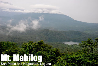
Mt. Mabilog (441+)


MT. MABILOG
San Pablo and Nagcarlan, Laguna
Major jumpoff: Purok 3 (Sandig), Brgy. Sta. Catalina, San Pablo
Alternate jumpoffs: (1) Brgy. Sulsuguin, Nagcarlan
(2) Lake Pandin, Brgy. Sto. Angel, San Pablo
LLA: 14°7’57″N, 121°21’30″E, 441 MASL
Days required / Hours to summit: 1 day / 2-3 hours
Specs: Minor climb, Difficulty 2/9, Trail class 1-3
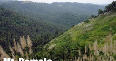
Features: Views of Southern Tagalog mountains and lakes
BACKGROUND
Nestled between the beautiful lakes of San Pablo City are mountainous terrains that straddle the city’s borders with nearby Nagcarlan and Calauan. Although they are dwarfed by surrounding giants, such as Mts. Banahaw and Mt. Cristobal, and the more distant Mt. Makiling, these mountains and hills are worthy destinations: they offer nice views of the mountains and the lakes; and they are also a trip to the heartland of the Southern Tagalog region, much like Manabu Peak and Mt. Malipunyo.
Among these peaks is Mt. Mabilog, which sits at the border of Brgy. Sta. Catalina, San Pablo, and Brgy. Sulsuguin, Nagcarlan. At 428 MASL, it is shorter than nearby Mts. Kalisungan and Atimla, but it is closer to the lakes, being within the city limits of San Pablo. Perhaps it is the rounded plateau that serves as the summit of this mountain that gave rise to its name, which means “round”.
There are at least three trails to Mt. Mabilog. The first, which the blogger used, is the western trail from Brgy. Sta. Catalina. The second is the southern trail from Brgy. Sto Angel, also in San Pablo. The third is the eastern trail from Brgy. Sulsuguin in Nagcarlan. The second and third trails are lakeshore trails. Traverses are very possible, but take note that these trails are not that established, and requires some navigational skills.

STA. CATALINA (WEST) TRAIL
This trail starts off at Purok 3 (Sandig), at the end of the cement road. From there, go straight and follow the footpaths, then turn right and ascent to a ridgeline that is marked by coconut trees. Beyond the ridge, you will encounter a house; follow the terrain going up until you reach the summit.
STO. ANGEL – LAKE PANDIN (SOUTH) TRAIL
This trail is preferred by many who would like to use the opportunity to visit two of San Pablo’s Seven Lakes — and also the most pristine: Lakes Pandin and Yambo, themselves beautiful points of interest in Laguna. From Pandin, take the footpath to the left, and follow through until you reach a ridgeline, which offers views of Mt. Yambo. Follow through, towards Mt. Mabilog.
SULSUGUIN – LAKE YAMBO (EAST) TRAIL
This trail is unique because it comes off from Nagcarlan; starting off from the Lake Yambo shore at Brgy. Sulsuguin. The ascent is straightforward, WNW, towards Mt. Mabilog; though as with the two other trails, it is best to get a guide since there are numerous foot trails.
In all of these trails, the characteristic environment is that of coconut and banana fields interspersed with forest and fruit trees, culminate in a somewhat steep ascent that leads to a wide summit that serves as campsite. Muddy trails must be expected during rainy season, as the trails are also used by locals, as well as their horses and carabaos, to go about their livelihood.
The campsite is overgrown during the rainy season, but it is a wide plateau during the dry season, and as mentioned, it is an excellent viewpoint not only for the lakes, but also for the mountains. You can behold the majestic Banahaw Trilogy (SE) right behind the twin lakes of Pandin and Yambo; catch a glimpse of Sampaloc Lake and the city proper of San Pablo (S), the Malipunyo Range (SSW), Mt. Makiling (W), Mt. Kalisungan (NNW), and Mt. Atimla (N).
Overall, Mt. Mabilog is a very nice and relatively easy destination in Laguna. It is recommended both as a dayhike and an overnight destination, especially in conjunction with a visit to the lakes.
ITINERARIES
Note: These itineraries are under development. Feedback is most appreciated!
STA. CATALINA (WEST) TRAIL
0400 Take Lucena-bound bus from Manila
0630 ETA San Pablo City. Breakfast
0700 Take tricycle to Ilog-bound jeepney
*Note: Tell trike to take you to the jeeps headed to Sta. Catalina
0730 ETD for Purok 3, Sta. Catalina
0800 ETA Sta. Catalina
0830 Start trekking
1000 Arrival at Ta Nilo’s Hut
1100 ETA Summit. Early lunch.
1130 Start descent
1300 Back at Purok 3, Sta. Catalina
1330 Take jeepney back to San Pablo
1400 ETA San Pablo. Take trike to Maharlika Highway
1430 From Highway, take bus back to Manila
1700 ETA Manila
STO. ANGEL (SOUTH) TRAIL
0400 Take Lucena-bound bus from Manila
0630 ETA San Pablo City. Breakfast
0700 Take tricycle to Nagcarlan-bound jeepney
*Note: Tell trike to take you to the jeeps headed to Nagcarlan
0730 ETD for Lake Pandin, Sto. Angel
0800 ETA Brgy. Sto. Angel
0830 Start trekking
0900 Arrival at rest at Lake Pandin
0930 Head up to Lake Yambo Viewpoint; Follow through
1130 ETA Summit. Early lunch.
1230 Start descent
1400 Back at Lake Pandin. Walk back to jumpoff
1430 Take jeepney back to San Pablo
1500 ETA San Pablo. Take trike to Maharlika Highway
1530 From Highway, take bus back to Manila
1800 ETA Manila
SULSUGUIN – LAKE YAMBO (EAST) TRAIL
0400 Take Lucena-bound bus from Manila
0630 ETA San Pablo City. Breakfast
0700 Take tricycle to Nagcarlan-bound jeepney
*Note: Tell trike to take you to the jeeps headed to Nagcarlan
0715 ETD for Nagcarlan
0800 ETA Nagcarlan; Take trike to Lake Yambo, Brgy. Sulsuguin
0820 ETA Lake Yambo (8 kms. from town center). Secure guides.
0820 ETA Lake Yambo (8 kms. from town center). Secure guides.
0845 Start trekking
1130 ETA Summit. Early lunch.
1230 Start descent
1400 Back at Lake Yambo. Tidy up / Raft at the lake
1500 Take trike back to Nagcarlan
1530 Take jeepney from Nagcarlan to San Pablo
1500 Take trike back to Nagcarlan
1530 Take jeepney from Nagcarlan to San Pablo
1615 ETA San Pablo. Take trike to Maharlika Highway
1630 From Highway, take bus back to Manila
1700 ETA Manila
*Note: It is possible to combine two different trails in a ‘rosary trail’ fashion (i.e. Sto. Angel-Sulsuguin) or a true traverse (i.e. Sto. Angel-Sta. Catalina).
PRACTICALITIES
Getting there. Buses to Lucena are available in Cubao (MRT3: Araneta Center – Cubao; LRT2: Cubao Station) and Buendia (LRT1: Gil Puyat Stn.). To San Pablo City, the fare is P127 as of August 2012. From the highway, take a tricycle to the jeepney terminal — always ask where it is, as the parking areas for jeepneys change every so often. The fare is P11 for Sta. Catalina and Sto. Angel. It is also possible to charter a tricycle for P150, one-way. The fare is P25 from San Pablo to Nagcarlan, and P100 for a tricycle from Nagcarlan to Lake Yambo.
Registration and guides. Barangay officials are friendly and can provide guides (optional) to accompany. Trails are confusing; if you do not have enough time to explore the area, better get a local guide to accompany you (guide fees are not fixed; P300 is reasonable for a half-day hike). There are no registration fees collected as of December 2012 for any of the jumpoffs. Since some parts of the trails are private property, note that policies may change.
Hiking notes. Brace yourself for muddy trails, and mosquitoes and other insects. Insect repellent is a must.
Camping notes. The campsite of choice is the summit itself; which is very wide and spacious; however, there are no water sources. Cellphone signal is present throughout the trail.
MT. MABILOG PICTURES
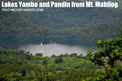

Views of, as well as the opportunity to visit Lakes Pandin and Yambo, comprise the main attraction of a Mt. Mabilog trek.

Another lake than can be glimpsed from the summit is the most famous of them all – Sampaloc Lake right at the city center of San Pablo.

Mt. Makiling can be seen at the west, from Mt. Mabilog’s summit

Another notable mountain that is visible from Mt. Mabilog is nearby Mt. Kalisungan (NNW).

The campsite, although wide, can be overgrown during the rainy season.
TRIVIA
The blogger’s account of Mt. Mabilog via Sta. Catalina can be found in Hiking matters #283; the two other trails (Sto. Angel and Sulsuguin) are narrated in Hiking matters #315. San Pablo City, where this mountain is located, is the blogger’s hometown.
The blogger’s account of Mt. Mabilog via Sta. Catalina can be found in Hiking matters #283; the two other trails (Sto. Angel and Sulsuguin) are narrated in Hiking matters #315. San Pablo City, where this mountain is located, is the blogger’s hometown.
Mt. Mabilog is one of four hiking destinations in PinoyMountaineer which offer views of at least three of the Seven Lakes of San Pablo. The other three are Mt. Cristobal, Tayak Hill, and Mt. Kalisungan.
Leave a Reply
12 Comments on "Mt. Mabilog (441+)"
Share ko lang po experience namin kanina sa Mt. Mabilog. I LOST ONE OF MY COOKING POT THERE. Pilit ko mang isipin na i was taken by a dog pero isang buong POT ang nawala overnight. May natira pa itong laman ( ulam namin kagabi) kay di ko muna niligpit at nawala na din sa isip ko na ligpitin. Anyway… Gaya nga ng sinabi ko… Iniisip namin na aso ang tumangay neto pero impossible kase may takip yun na kung ngipinin man ng aso (pag angat ng ulo nya e mahuhulog na ang takip.) at makakain na ng aso ang laman neto. PERO wala! ni takip ng pot ko e wala. Umikot na kame sa perimeter pero wala talaga kameng makita. Sige sabihin natin na aso ang kuhuma ASO… ASO NA MAY KAMAY NA KAYANG BITBITIN ANG POT. ANG TINDE MGA KAPATID. AND ADDITION TO IT. MAY BANTAY KAME "KUNO" NA GALING SA BRGY.YAMBO. NA MAGBABANTAY "KUNO"
KUNG DAGA NAMAN ANG KUKUHA NUN E MALAMANGBUNG DAGANG UN E NAGIGYM. MALAKI ANG MUSCLE NA DAGA.
IPINAGBIGAY NA NAMIN SA PAMUNUAN NG LAKE PANDIN ANG INSIDENTE AT GAGAWAN DAW NILA NG ACTION. ( VIA STO. ANGEL KASI ANG JUMP OFF NAMIN AT DUN KAME BINIGYAN NG GUIDE)
SANA MAGSILBING ARAL ITO SA AAKYAT SA MABILOG NA LIGPITIN ANG GAMIT BAGO ILAPAG ANG LIKOD SA TENT
SIR GIDEON. SANA PALUSUTIN MO TONG COMMENT KO. PEACE
Hello Sir / Ma'am, Good Day! Meron po ba umakyat sa mountain na ito lately? wala po kasing new comments since may 2013. Our group is planning to have a climb this month here. We would like to ask kung saan po ung madaling trail sa mount mabilog? tsaka po which trail will be more convenient kung galing po sa alabang?
Thank you po!
sched po nmen here on may 20 next monday . 4 lng kame .
baka gusto nio sumabay mga sir ma'am
just pm me
kevinmchale.fortuna@gmail.com
we'll go here on may 20 next monday . 4 lng kame . puro noob . u might wanna lead us .or join . just pm me sir ma'am
kevinmchale.fortuna@gmail.com
You can add Lake Hopping (7 Lakes of San Pablo) sa IT nyo dito, then Underground Cemetery at Bunga Falls sa Nagcarlan, Laguna. Just a few minutes away.