
Mt. Paliparan (562+) in Tanay, Rizal


MT. PALIPARAN
Tanay, Rizal
Trailhead: Barangay Hall, Brgy. Cuyambay, Tanay
LLA: 562 MASL (Peak 2 / “summit”)
Days required / Hours to summit: 1 day / 2.5-4 hours
Specs: Minor climb, Difficulty 4/9 +R (with rock precaution), Trail class 1-5
Features: Rock formations, scenic views, waterfalls, Dumagat village
Article history: Created 29 May 2016 by Gideon Lasco
BACKGROUND
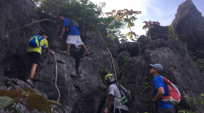
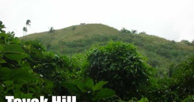
Another hiking destination in Rizal characterized by rocky, limestone prominences is Mt. Paliparan in Brgy. Cuyambay, Tanay, Rizal. Named as such by local Dumagats because it once served as a venue for kite-flying contests by their youths, this destination was just opened to hiking activities in April 2016. Passing through woodlands and occasional grassy slopes, the trail is not yet well-established but is gentle and gradual, save for the occasional scrambling up the rocks that require some caution and care.
Highlights of the hike include scenic views of Laguna de Bay and the Pililla wind turbines, rock formations, the impressive Tungtong Falls, and Tuoy – a nearby Dumagat village. Though not as spectacular as the Sierra Madre-facing (i.e. east-facing) mountains such as Mt. Irid or Mt. Lubog, the mountain has its own unique rewards. Easy enough to do in a day, it is another recommended dayhike from Manila.
ITINERARY
0400 Take jeep from Sampaloc to Cogeo
0500 ETA Cogeo. Take jeep to Cuyambay junction
0615 ETA Cuyambay. Take habal-habal to Brgy. Hall
0630 ETA Barangay Hall. Register / Secure guides
0700 Start trekking
0930 ETA viewpoint / Peak 1
1030 ETA Peak 2. Star
1200 Lunch at Tuoy village
1300 Head to Tungtong waterfalls
1500 ETA Tungtong waterfalls.
1530 Resume trek
1600 Back in barangay hall. Tidy up
1700 Return to Manila
2000 ETA Manila
PRACTICALITIES: MT. PALIPARAN
| Transportation | Public (1) Jeep, Sampaloc to Cogeo [P20, 30-60 mins] (2) Jeep, Cogeo to Cuyambay [P48, 60-80 mins] (3) Habal-habal, Cuyambay junction to Brgy. Hall [P25/5 mins]Note: Jeepney travel times are highly variable due to the traffic, but you are likely to get the lower end if you leave very early. Private: Marcos Highway > Brgy. Cuyambay – turn right – follow the road until you reach the barangay hall |
| Registration | Logbook at trailhead; P20 fee |
| Guides | Available, required: P500/day |
| Contact numbers | Jeep rental (Rene) – 09127570867 Brgy. Cuyambay – 09124795185 Van rental (from Manila) – 09332810163 |
| Campsites and waypoints ⛺ | Campsites: (1) Potentially at Tuoy village |
| Water sources 🚰 | At the Tuoy village junction and thereafter along the stream leading to the waterfalls |
| Cellphone signal 📶 | Present in most parts of the trails. |
| River crossings | Some trekking on or along a stream |
| Roped segments / Technical parts | None but beginners may benefit from a backup rope |
| Limatik | None |
| Lipa | None |
| Rattan | None |
| Hiking notes | Exercise precaution on rocky parts up the summit, the viewpoint, and the waterfalls. |
| Sidetrips | Nagpatong Rock Formation, a one-hour hike from Brgy. Cuyambay. Masungi Georeserve en route (reservation required). |
| Alternate trails | Road that connects to Tuoy village |
| Dayhikable | Yes (4-7 hours to complete the whole circuit) |
| Facilities at jumpoff | (+) Sari-sari stores (+) Restrooms / paid wash-up places (+) Parking |
| Estimated budget | P400-500 from Manila |
MT. PALIPARAN PICTURES


TRIVIA
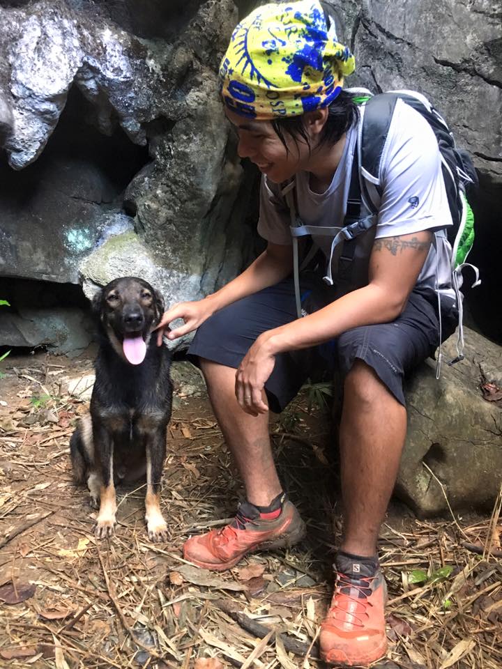
Ogag, a guide dog in Mt. Paliparan, has been featured in Pinoy Mountaineer Facebook page and is one of the attractions, by himself, of the mountain as of June 2016. He accompanies all groups of hikers and was part of the initial exploration and trailblazing.
Leave a Reply
1 Comment on "Mt. Paliparan (562+) in Tanay, Rizal"
Hi Sir,
Share ko lang Itinerary namin noong June 12, 2016. (Nagpatong Peak + Tungtong Falls + Paliparan peaks 1,2 & 3)
Adjusted sa pinakamalapit na minuto.
7:50 AM – Arrival at Brgy. Hall of Cuyambay (Preparation, registration, secure guide, orientation etc.)
8:30 AM – Arrival to Jumboree ( jump-off to Nagpatong Peak)/ Start trek
9:30 AM – Nagpatong Peaks ( Enjoy the view of Mt. Batolusong and Masungi Georeserve from Rock 1 and Rock 2 / take a rest)
10:45 AM Descend
11:30 AM Arrival to Jumboree take habal habal back to Brgy. Hall
12:00 PM Lunch and rest at Brgy. Hall
12:45 PM Start Trek to Tungtong Falls and Paliparan Peaks
1:30 PM Arrival Tungtong Falls ( Upper part)/ Enjoy the view and falls)
2:43 PM Arrival to peak 1 ( we take a shortcut or another trail from the upper part of tungtong falls to peak 1)
3:20 PM Arrival Peak 3 Enjoy the view of Mt. Sembrano (we go directly to peak 3 then go down to peak 2)
4:00 PM Arrival to Peak 2
4:20 PM go back to peak 1
5:30 PM Arrival to Brgy Hall
Hindi na kami nakapunta sa Tuoy Village kasi kinulang na kami sa oras at inabutan kami ng ulan. Siguro kung maaga kami nag start pwede pa. Buti na lang kabisado ng guide namin na si Kuya Mulo ang mga shortcut at ibang trail ng bundok kaya natapos namin ang nagpatong, tungtong at paliparan in one day.
Napakaganda ng view sa mga peaks specially sa Nagpatong kung saan makikita mo ang Mt. Batolusong at Masungi Georeserve. Sa Peak 3 naman makikita mo ang Mt. Sembrano. Sulit ang pagod.