
Mt. Daraitan (739+)

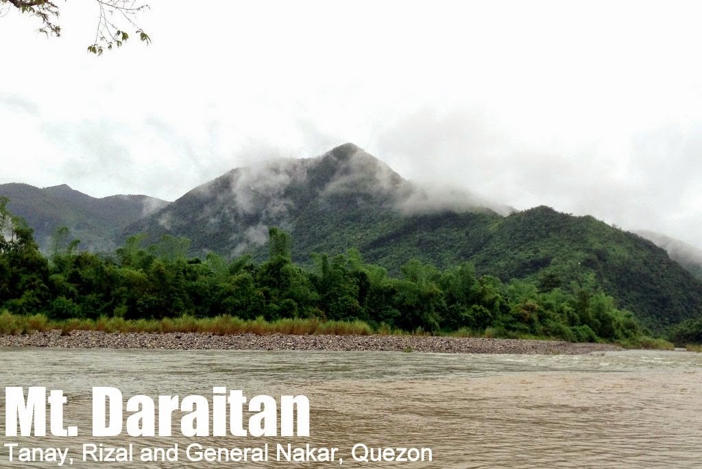
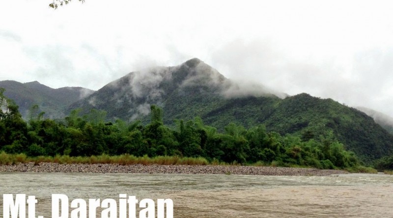
MT. DARAITAN
Tanay, Rizal and General Nakar, Quezon
Major jumpoff: Brgy. Daraitan (village centre), Tanay
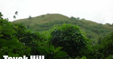
A gem at the heart of the great Sierra Madre mountain range, close enough to Manila to do as a dayhike, is Mt. Daraitan, which sits near the border of Tanay, Rizal and General Nakar, Quezon. A former logging area, the village that bears the mountain’s name is now an ecotourism site that offers outdoor attractions such as caves, springs, natural pools, and limestone formations. A model for ecotourism, the barangay has an organised system for handling visitors, including trained local guides.The hike up is a (mostly) straightforward 600-meter ascent that might feel steep to those not used to hiking. There are, however, plenty of holds and the trail is well-maintained. The forest environment is similar in characteristics with Mt. Pinagbanderahan, which also lies in the Sierra Madre – but Daraitan has more rewarding limestone viewpoints and a much more challenging hike.
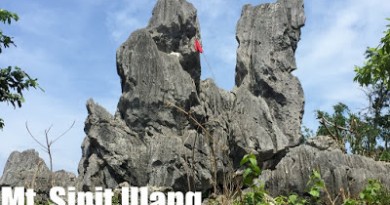
At the summit, one can see the Sierra Madre mountains (E, NE), the meandering Daraitan River, and a glimpse of Laguna de Bay with its outlying mountains (i.e. Makiling and Sembrano) and the mountain within it: Mt. Tagapo. There is space for several tents if you wish to stay overnight. From the summit, instead of returning all the way to the barangay, a recommended route to take is the trail to Tinipak River. Though the trail itself is very similar to the ascending trail, Tinipak River, with its beautiful limestone boulders, is a great highlight and must not be missed! This is also a popular camping ground which gives the option of exploring the springs, natural pools, and caves in the area.
Mt. Daraitan is a great sampler for hiking up the relatively unexplored Sierra Madre mountains, and along with the other attractions in Daraitan, particularly the scenic, lunaresque Tinipak River, is a highly recommended dayhike or overnight destination from Manila.
1200 Lunch along the way
1300 Resume trek
1800 Dinner / socialsDay 2
0545 Sunrise viewing at the limestone formations
0700 Breakfast / Break camp
0800 Start descent to Tinipak River
1100 Arrival at Tinipak River. Lunch / Sidetrips
1530 Proceed to Brgy. Daritan via riverside trail
1615 Back at Barangay Hall; tidy up
1730 Head back to Tanay, Rizal via tricycle
1830 Back in Tanay Rizal. Take jeepney back to Shaw / Cogeo
2000 Back in ManilaNote: It is also possible to camp in Tinipak River and do Mt. Daraitan as a dayhike on Day 1 or 2 of an overnight trip.
PRACTICALITIES: MT. DARAITAN
|
Transportation
|
Public (1) Jeep or van, EDSA-Shaw Crossing to Tanay [70-90 pesos; 1.5 hours]
(2) Jeep, Tanay to Sampaloc [26 pesos, 45 minutes) (3)Tricycle, Tanay to Brgy. Daraitan [100 pesos/person; 30 minutes] (4) Raft, Daraitan river [10 pesos; 1 minute] (5) Tricycle, Daraitan river to Brgy. hall [10 pesos/person; 5 minutes] *Alternatively for 1-2, take jeep from Cogeo to Sampaloc *Alternatively for 2-3, if going overnight, take jeep from Tanay to Daraitan that leaves at 1300H and 1500H (and returns from Daraitan to at 0900H and ~1200H) Approximately 3-4 hours travel time because of various stops and delays. Private. Head out to Marcos Highway and follow through the Tanay-Infanta Road. Make a left turn to the rough road that leads to Brgy. Daraitan, and park just before the river which used to be connected by a wooden bridge. Cross the river following 3-4 on the ‘Public’ section above. Parking is available before the river crossing. Approximately 2-2.5 hours travel time. |
|
Registration
|
(1) Logbook at the barangay hall of Daraitan. P20 registration fee.
|
|
Available; assigned at the barangay hall (500 pesos for the dayhike; 1250 for overnight)
|
|
|
+639069533470 – Willy (Head Guide)
+639989881590- Tanay Tourism Office +09463475403 – Van rental |
|
|
Campsites and waypoints
|
Summit (14°36′48.5′′N 121°26′19.5′′ E 739m)
Tinipak River (14°36′10.6′′N 121°26′40.4′′ 299m) |
|
Water sources
|
None in the upper reaches of the mountain; present in Tinipak River
|
|
Cellphone signal
|
Sporadic at the lower reaches
Present from 600m up to the peak
|
|
River crossings
|
None in the hike proper, but Tinipak River itself can be crossed as part of side trips (i.e. swimming in lagoons, visiting caves etc.)
|
|
Roped segments
|
None
|
|
None
|
|
|
Minimal
|
|
|
Rattan
|
Minimal
|
|
Hiking notes
|
The rocks up and down the mountain can be slippery. If it is raining heavily the trail to Tinipak River may not be advised by the guides.
|
|
Sidetrips
|
In Tanay, Daranak and Batlag Falls can be visited before visiting Daraitan, especially if you plan to take the regular afternoon jeepney. In Daraitan, Caves and Tinipak River exploration can count as side trips.
|
|
Alternate trails
|
There are hunters’ trails that go deep into the Sierra Madre mountains. One of the nearby peaks, Mt. Lugang, is being considered as another ecotourism site.
|
|
Yes (2.5-4 hours to summit; 1.5-3 hours down on either of the above-mentioned trails)
|
|
|
Facilities at jumpoff
|
(+) Sari-sari stores
(+) Carinderias / paluto (+) Wash-up / shower places |
|
500-700 (dayhike)
800-1000 (overnight) |
MT. DARAITAN PICTURES
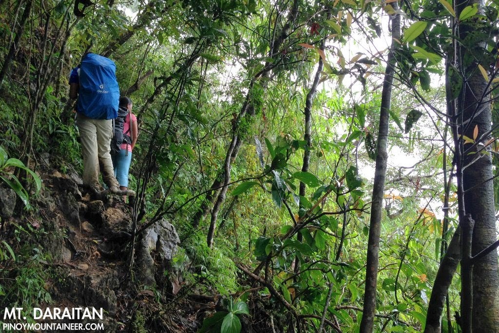 |
| The trail up Mt. Daraitan is moderately steep and beautifully forested |
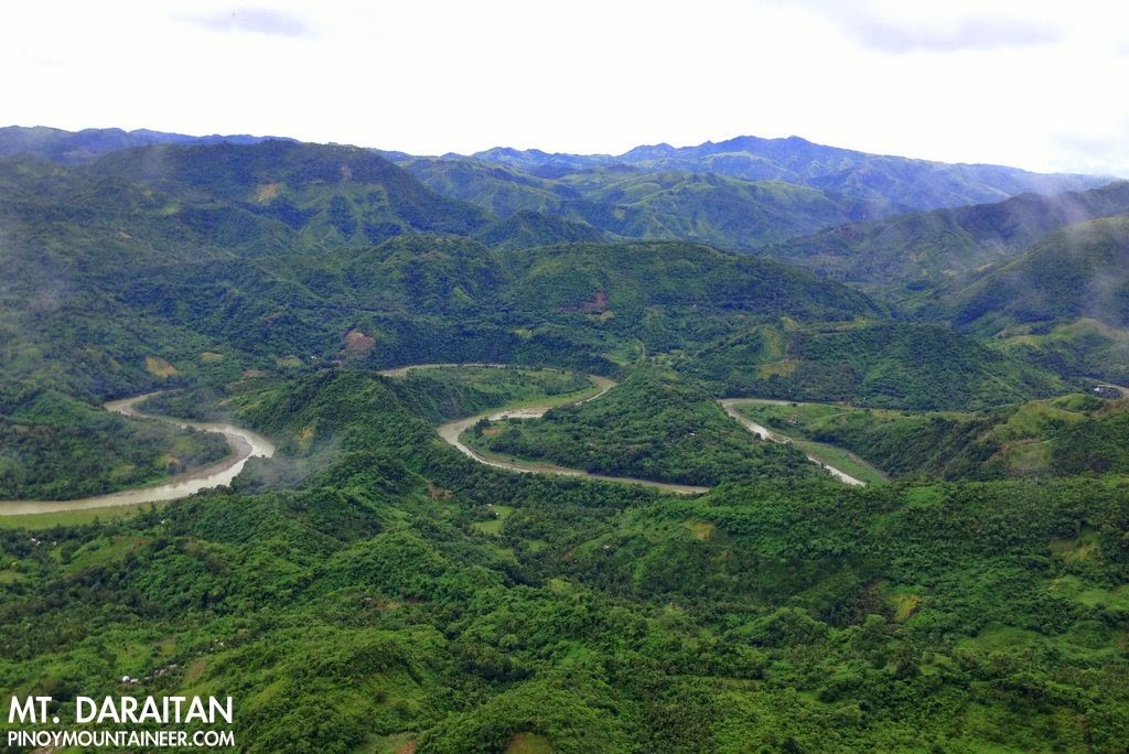 |
| Meandering Daraitan River as viewed from the summit |
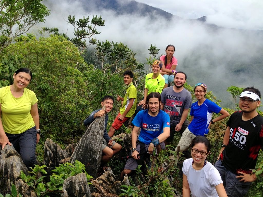 |
| At the summit of Mt. Daraitan with its limestone formations |
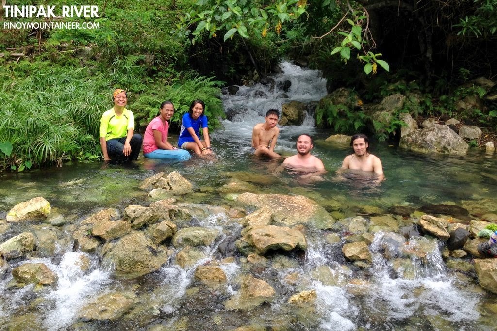 |
| Taking a break in one of the springs along Tinipak River |
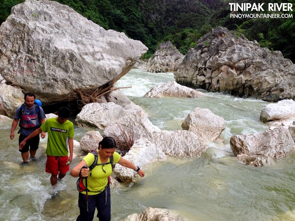 |
| The 2.6 km trek from Tinipak River to the barangay hall is one of the highlights of Daraitan |
Leave a Reply
41 Comments on "Mt. Daraitan (739+)"
good am mga sir/mam pupunta po kami ngayon sa mt daraitan kamusta po panahon dun. may bagyo po kasi bagyong lando na tatama ng umaga sa aurora baler, tatamaan kaya ang tanay rizal, safe po ba pumunta thanks po
as far as i know available naman po ang tryk sa Tanay proper papunta sa Daraitan mga sir, ang di ko lang alam ay if available 24hrs yung mga Guide. i got this number from a friend na naghike last month sa daraitan, number ng tryk driver , sabi nya mabait daw.. kuya PIO 09480424947
We're scheduled to climb mt. Daraitan tomorrow. This will be an exciting day for us since this is our first time to explore mt. Daraitan. This website is a great help for newbies like us. More power Sir Gideon!
hello mga mam sir sino aakyat sa daraitan ngaung september25 pwd ba mag night trek dun?
hi Andrea, I love to join your group pls email me at [email protected]
update me when ok? Thank you !!