
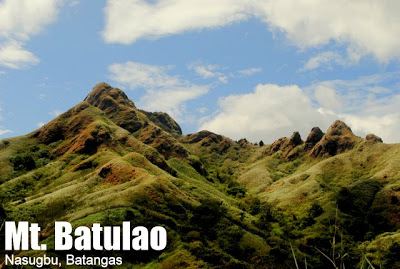
Mt. Batulao (811+)


MT. BATULAO
Nasugbu, Batangas
Jump-off point: Evercrest Golf Course, Nasugbu
LLA: 14.0408 N 120.8011 E 811 MASL
Days required / Hours to summit: 1 day / 2-4 hours
Specs: Minor climb, Difficulty 4/9, Trail class 3 with 60-70 degrees assault

Fork to summit: 1.5-2 hours. Take the left, downward path to follow the old trail. You will enter a woodland, then emerge into the campsites (or stations) marked 1-10. At the earlier campsites the facilities are larger and there is a water source. There is a logbook and you will have to pay a registration fee of P20.Same old slopes till station 8, after which the final ascent commences. Beyond this point, at the you have to be extremely careful because the trails are really steep, there are loose stones, and the winds can set off you balance although as of 2012, they’ve carved out steps from the challenging parts, making this leg easier. This will just take 30-45 minutes, though. Campsites are marked from 1-10, with stations 8-10 being the steep parts, “Campsite 10” being the summit itself.NEW TRAIL (WEST)
 Fork to summit: 1-1.5 hrs. Take the right/middle, upward path (but not the extreme right, which goes downward). There is a small wooden marker. You will immediately ascend into a hill, and continue ascending and descending some so-called numbered peaks. Around 20 minutes uphill is the lone campsite of the trail, good for several tents. There is a water station – the locals who man the site sell water which they get from a nearby river (around 30 minutes away). Here is also the counterpart registration area of this trail.
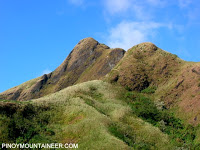
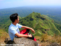 At the peak, the rocky landscapes climax into beautiful formations. Set in the backdrop of the plains of Cavite and Batangas, the photo ops are excellent. Views include the peninsula of Calatagan (SE), the coastline of Nasugbu (E), Mt. Talamitam (ENE), the mountains of Maragondon, Cavite (N), the Tagaytay highlands (WNW), Taal Lake (W), behind it, Mt. Maculot (WSW), and the vast Balayan Bay (S). Here the breezes that menaced the assault are now a refreshment.Going down with a brisk pace takes just 1-2 hours. From the Evercrest entrance, you may cross the highway to avail of the makeshift shower areas in the sari-sari stores. After the Batulao climb, which is a challenging Difficulty 4/9 dayhike, a postclimb meal in Tagaytay with its plethora of food choices – is a blissful reward.
ITINERARIES
0400 ETD Coastal Mall bus terminal to Nasugbu, Batangas
0715 Arrival at Evercrest
0730 Start trek
0845 Arrival at Fork. Take the left, downward trail that enters some woodland
1100 Arrival at summit; lunch
1200 Start descent via New Trail, which is opposite the Old Trail at the summit
1630 ETA Tagaytay; anything goes from hereNew to Old Trail
0715 Arrival at Evercrest
0730 Start trek
0845 Arrival at Fork. Take the middle/slightly right upward trail
1200 Start descent via Old Trail, which is opposite the New Trail at the summit
1630 ETA Tagaytay; anything goes from here
PRACTICALITIES: MT. BATULAO
| Transportation | Public (1) Nasugbu-bound bus, Coastal Mall to Evercrest – P104 (2) optional Tricycle, Evercrest to trailhead P25/person Approximately 2.5 hours travel time Private From Manila, go to Tagaytay via SLEX (Greenfield exit) then proceed via the Tagaytay-Nasugbu Road until you reach Evercrest. Go past the gate, follow through, turn left at the fork, and then go down the rough road to the trailhead. Approximately 2 hours travel time but do avoid the weekend lunch/dinner Tagaytay crowds. |
| Registration | Logbook at Old and New Trail campsites. Total fees per hiker: P20 per trail if you are just passing; P30 if you are camping on that trail
Note: As of November 2015 there is also an attempt to impose a registration regime at the trailhead itself – this is apparently supported by the Nasugbu Tourism Office. Standby for updates. |
| Guides | Available (P300-400/day); there are some reports that it is required but there are also those who say that guides are not mandatory. |
| Contact numbers ✆ | New Trail Campsite (Roel) +639279008496 Nasugubu Police Station – (043) 931-9952 |
| Campsites and waypoints ⛺ | Campsites: (1) New Trail campsite 🚰📶 (1) Old Trail campsite 🚰📶 |
| Water sources 🚰 | None in normal course of trail but available in campsites – ask from caretakers. |
| Cellphone signal 📶 | Present in most parts of the trail |
| River crossings | None |
| Roped segments | Fixed rope in steep part of Old Trail (between Camp 8 and summit) that can get slippery when wet |
| Limatik | None |
| Lipa | None |
| Rattan | None |
| Hiking notes | Can be very muddy during the rainy season and dusty/windy during the dry months
Mt. Batulao is generally safe and we have not received any reports of theft. It helps that there are locals who stay in the campsites. In February 2012, an accident involved the death of a first-time hiker who fell from Peak 8 of the New Trail; this however is an isolated incident and should not be a cause of worry provided that hikers are always careful and properly oriented. |
| Sidetrips | Nasugbu or Tagaytay; Twin dayhike with Mt. Talamitam (see itinerary here) |
| Alternate trails | There is a walkable trail to Mt. Talamitam |
| Dayhikable | Yes (2-3 hours to summit; 1.5-2 hours down) |
| Facilities at jumpoff | (+) Sari-sari stores (+) Shower facilities (+) Parking – expect to be charged P50 |
| Estimated budget | 600-900 |
ADDITIONAL NOTES
Private transportation. Going by car is also easy: just go to Tagaytay via SLEX (take Sta. Rosa or Mamplasan-LIIP exit and follow through) and make a right turn upon reaching the Tagaytay Rotonda, going all the way beyond Tagaytay Public Market and past the marker welcoming you to Nasugbu. Evercrest is just a little past KM. 72. Inside Evercrest, go straight then make a left turn. You can either park in the village (take the right, downward road) or follow through and randomly park in the road, or fall for some ‘parking spaces’ that locals have created for P50-100/day.


Becuase of the many ‘ups and downs’ of Mt. Batulao, the altitude gain from the jump-off point to the summit is actually less than 300 MASL.

Leave a Reply
671 Comments on "Mt. Batulao (811+)"
5x kailangan mag register.. 2x na 30 pesos at 3x na 20 pesos.. latest update po yan..
I am Lee Roy Anthony Mendoza Sarmiento, and I would just like to narrate what happened in the morning of November 08, 2015 at the first registration ‘hall’ in Mt. Batulao. This is the shop that sells balisongs and katana (samurai) knock-offs.
We are all 11 climbers / trekkers. Eight of us are well-experienced climbers, only 3 are 1st-timers. One of us already climbed Mt. Batulao 12 times, and has been accompanying friends from the beginning. He’s also the first one who heard that the locals are planning to implement a mandatory rule of assigning a guide to all who wish to go to the mountain.
We registered at around 8:30AM. The local who is sitting at the desk gave us a logbook. He wears an army jacket, an orange shirt beneath it, adult, and about in his 40s. There are several locals standing near his desk (guides, I pressume). As we started to log in, he asked if we already have a guide. We told them we don’t need one as the majority of us knows the mountain very well. He said that getting a guide is now mandatory. Even the locals by his desk gave the same statement in chorus. My friend then said that that is not true, and that he was just there 2 days ago and was not mandatorily issued a guide. The ‘desk guy’ then said if we have a problem about the policy, we should call the one in charge and prepared to give my friend this ‘guy in charge’s’ number. My friend then said that this ‘guy in charge’ should be the one to call him, and that we have posted all our numbers in the log book. I then supported my friend by saying that if that policy is true, let us see the baranggay ordinance that supports it. ‘Desk guy’ can’t show us anything, and started reasoning out that mandatorily hiring a guide is our way of helping the locals. We all told him that if it’s help that they need, we’ll be very happy to donate. He then answered that they don’t want to take money that they haven’t earned. I then answered him that he’s hiding an unjustified rule behind a good value that loops back to a devious motive – which is to extort money by giving a service that we don’t need. To block his answer, I again asked for the baranggay ordinance that will support his claim that getting a guide is mandatory. He then answered that it’s ok, we can still pass through, but with this warning: “Pero bahala kayo kapag may nangyari sa inyo, wala na kaming pakialam.”.
Now with my observation. He may be calm and respectful, even with his twisted and corrupt reason for mandatorily issuing a guide for a climber, but with that warning, it simply goes beyond a simple disclaimer. Needless to say that the conversation slowly escalated into an argument, that warning he gave us inappropriately sounded like he wishes us bad luck so we’ll regret not taking a guide. That last statement of his stripped off whatever mask of hospitality that he wears to hide the extortion that he wants to impose.
Now, about the objective part of this issue, and the entire climb experience as well.
1. He has no ID to identify him as an official to implement a mandatory rule in the area. He did not even identify himself, while we are required to log our names and contact numbers in the log book.
2. THEIR claim that getting a guide is now mandatory is not supported by a baranggay ordinance.
3. One guide is P500. If you hire a guide, there’s no official receipt – further exposing that the rule is not supported by a baranggay ordinance.
4. If they really are concerned about everyone’s safety who wish to go to the mountain, why can’t they assign a mandatory guide to the adventure racers / ultra marathoners / trail runners who frequently use the mountain for their practice / workout? Can they assign a guide to each runner and keep up with the pace? This exposes another anomaly in the mandatory rule that they wish to implement.
5. If they’ll finally get the baranggay ordinance about the mandatory guide, the rule should be with an exception. Again, about the point of not needing the guide – or better yet, can not afford a guide. In this case, a signed waiver should be given to these individuals, waiving off all responsibility by the locals should anything unfortunate happen.
6. At choke points that require using a rope or difficult terrain, the guides themselves should allow atleast 5 ascends and 5 descends at a time, until everyone is able to pass. This will prevent people from waiting in a long line, exposing them to the elements like the sun, wind, or even rain, for an extended period of time. In this incident, I’ve encountered a guide prioritizing his group, which is in superior number, in going down the rope at the old trail right before the summit. He ignored the other guide’s plea to atleast allow them to take their turn for a while so as not to wait for a long time, being exposed in the hot sun. This guide would not have listened to anyone, had I not been insistent on him with my reasons.
7. Again, about their ‘concern’ for our safety, why have we not seen a single guide with a first aid kit? Or better yet, a guide who went through basic first aid training, to say the least?
8. As you trek along, you’ll encounter about 2 – 3 stopovers that will require you to log (again) and pay P10, P20, and P30. I asked the ‘desk guy’ what those fees are for, he told us it’s for passing through private property. Granting that we climbers / trekker / runners are a disturbance to these properties, have they not benefited as we pass along? We buy cold drinks, coconut juice, halo-halo, food, and other retail items from them. They have also set up toilets, and use of these toilets, has a fee (of course).
9. If they are going to use again the usual scapegoat of using the fees for the ‘improvement’ and ‘care’ of the mountain, then why do we still see the usual trash like cigarette butts, candy wrappers, etc., along the trail? To prevent this, why have we not seen redundant warnings about LNT (Leave No Trace) at the jump off, and along the trail?
10. Lastly, not all of the locals and guides in this place are like the ones we had an argument with. Most of them are nice, helpful, and good-natured, hospitable people. We even met a guide who has first aid training and cerfitication by the government.
A local told us that in one of their meetings, he heard that one of the reasons why they want to impose a fee on us is that they know that climb organizers earn income by bringing people into their mountain. They want a piece of the pie. What sort of justification of extortion is this? A climb organizer owes you money ‘coz he earned by bringing people to your mountain? What if we say that we city dwellers should charge people from the provinces if you earn money in the city? Or we mandatorily assign a guide, for the safety of the ‘probinsyanos’?
The sad part of this story is that since the ramped-up implementation of the unsupported mandatory guide rule, visits have dwindled. Business like tricycle rides and retail store sales have plummeted. The majority of the locals are being affected because of the corrupt actions of a few.
Hi guys.possible kaya na mag mountain bike sa mt.batulao? gusto kasi namin subukan. Salamat!
Good day! Is Mt. Batulao open today? My group were scheduled to climb later this afternoon but we hesitate though because the typhoon Lando is said to land in the northern part of Luzon and will also bring rainstorms in some parts of CALABARZON. I just want to know if it’s possible or okay to hike with this kind of weather. And also if there’s any person to contact in Mt. Batulao for updates. Thank you!
– Luli
**** R E M I N D E R ****
Sa lahat po ng nag babalak na umakyat sa Mt. Batulao, May bago po doong Tourism Outpost na nanghaharang ng Mountaineer and Claiming na “Compulsory” na daw po ang mag “Hire” ng “Guide” bago umakyat.
H’wag po kayong maniwala na compulsory ang pag hire ng guide.
Naka usap po namin ang sinasabi nilang taga Tourism na si Ms. Perla Rupo, according to her, nakabinbin pa ang hiling ng mga local guides na maging compulsory ang pag hire ng guide sa pag akyat sa Mt. Batulao and it’s up to the baranggay captain to sign the ordinance.
Naka usap po namin ang mismong Brgy. Captain ng Brgy. Kanlaway na si Brgy. Captain Ruel Fenol, and according to him. hindi pa inaaprobahan ang ordinance na iyon at very hesitant sya to sign dahil ang hinihiling na guide fee ay Php500 na ayon sa Kapitan ay may kamahalan.
Tandaan, ang guide fee po sa Batulao ay around Php300 lamang po at huwag maniniwala sa kahit anumang Papel na ipapakita ng mga nanghaharang sa jump off na nanghihikayat mag hire ng guide bago umakyat. Suriing mabuti ang mga kasulatan na ipinapakita nila, tingnan kung ito ba ay issue ng Baranggay Hall ng Brgy. Kanlaway at kung pirmado ito ni Brgy. Capt. Ruel Jaro Fenol. Kung kayo ay pinipilit mag hire at di pinapayagang umakyat, kunin ang pangalan ng inyong nakausap at magsumbong agad sa baranggay.
Good day! Is Mt. Batulao open today? My group were scheduled to climb later this afternoon but we hesitate though because the typhoon Lando is said to land in the northern part of Luzon and will also bring rainstorms in some parts of CALABARZON. I just want to know if it’s possible or okay to hike with this kind of weather. And also if there’s any person to contact in Mt. Batulao for updates. Thank you!
– Luli