

Mt. Hapunang Banoi (517+)


MT. HAPUNANG BANOI
Rodriguez, Rizal
Major jumpoff: Brgy. Wawa, Rodriguez, Rizal
LLA: 14°44′25.3′′ N, 121°11′30.4′ 517 MASL (+460m)
Days required / Hours to summit: 1 day / 2-3.5 hours
Specs: Minor, Difficulty 4/9, Trail class 1-4 with limestone scrambling
Features: Limestone formations, scenic views of Sierra Madre and Rizal province
Article history: Created July 27, 2015
Author: Gideon Lasco
BACKGROUND
The documentation of the beautiful mountains of Montalban, Rizal continues, and Pinoy Mountaineer is very supportive of promoting ecotourism in the area as an alternative to illegal logging, charcoal making, and other destructive activities that are threatening the Sierra Madre. Moreover, these mountains can help spread the impact of hiking, diminishing the crowds of Maculot, Pico de Loro, and Batulao. Just an hour away from Metro Manila, Brgy. Wawa is especially promising, and the past several months have seen efforts from the barangay to make things more organised.
After the twin mountains of Mts. Pamitinan and Binacayan, as well as the distinctive Mt. Ayaas, comes Mt. Hapunang Banoi, which is actually conjoined with Mt. Pamitinan. This ‘elder silbing’ of Pamitinan and Binacayan features the same limestone formations, but it is arguably a notch higher in terms of difficulty, altitude, and length.
Banoi is the Tagalog word for eagle, and the name of the mountain comes from its folkloric seat as the ‘place where eagles come to dine’. The fact that there are other mountains named Banoi – the one in Lobo, Batangas and Tukduang Banoi in Tanay, Rizal facing Mt. Irid – speaks of the extent of the eagles’ domain in the past. Unfortunately, the eagles have dwindled in number – but guides say that they continue to see them occasionally.
Mt. Pamitinan and Mt. Hapunang Banoi share a common trail that passes through the rock climbing walls of Montalban until the junction with Mt. Pamitinan (277 MASL). From here, the leftward trail leads to Hapunang Banoi. Bamboo groves admix with rocky trails, culminating in a rocky ridge of sharp limestone that is breathtaking. The summit, too, is an anarchic rock formation, with minimal
flat spaces – but a worthy achievement after all the scrambling! The observant hiker will certainly not miss Mt. Arayat, Mt. Balagbag, Mt. Ayaas, Mt. Banahaw, Mt. Cristobal, and more peaks on a clear day!
The local guides say that Mt. Hapunang Banoi is their favorite and it is easy to understand why. I do think that Mt. Pamitinan, with its dramatic peak, has its own character and is still my recommended first mountain in Wawa. But for those who have already done it, Mt. Hapunang Banoi is certainly a great reason to go back – it’s not just “more of the same”, but comes up with its own interesting sights. And of course you can also do both Pamitinan and Hapunang Banoi on the same hike!
ITINERARIES
MT. HAPUNANG BANOI DAYHIKE
0400 Take van from Cubao to Eastwood, Rodriguez, Rizal
0530 ETA Rodriguez, Rizal; take trike or jeep to brgy. Wawa
0600 Arrival at Brgy. Wawa. Register at DENR station / barangay hall
0630 Start trek up Hapunang Banoi
0730 Arrival at junction with Mt. Pamitinan
0930 ETA summit
1030 Start descent
1200 Lunch at junction
1300 Resume descent
1400 Back at Brgy. Wawa. Explore the area / Sidetrips
1700 Tidy up then take outbound trike
1930 Back in Manila.
MT. HAPUNANG BANOI + PAMITINAN DAYHIKE
0400 Take van from Cubao to Eastwood, Rodriguez, Rizal
0530 ETA Rodriguez, Rizal; take trike or jeep to brgy. Wawa
0600 Arrival at Brgy. Wawa. Register at DENR station / barangay hall
0630 Start trek up Hapunang Banoi
0730 Arrival at junction with Mt. Pamitinan
0930 ETA summit
1030 Start descent
1200 Lunch at junction
1300 Assault Mt. Pamitinan
1430 ETA summit of Mt. Pamitinan
1530 Start descent
1630 Back at junction
1730 Back at Brgy. Wawa. Tidy up then take outbound trike
2000 Back in Manila.
|
Transportation
|
Public (1) Van, Cubao to Montalban (Eastwood) [P50; 1-1.5 hours]
(2) Jeep or trike, Montalban (Eastwood) to Wawa [P7.50-P10; <30 mins]Alternatively, take any transport to Montalban (i.e. via Marikina) then take (2) Approximately 2-3 hours travel time because of various stops and delays. Private. Head out to Rodriguez, Rizal via Marikina and San Mateo, then follow the road to Wawa Dam. There is an entrance of P50 for private vehicles. Parking slots are available in front of the tourism office Approximately 1.5-2.5 hours travel time. |
|
Registration
|
In order:
(1) Logbook at the DENR station in Wawa. (2) Logbook at the barangay hall P2 registration per person at the DENR station and donation of any amount in the barangay hall |
|
Available; assigned at the tourism office/ barangay hall. No fixed rates but P400/day is suggested (add more if twin dayhikes)
|
|
|
+639493956589 (Emman, guide)
+639473868778 (Ogie, guide) +639983266559 (Richard Salina, guide) +639295497211 (Joni – barangay) Please share more contact numbers if you have them. Better to call the contacts rather than text as they may always have load. |
|
|
Campsites and waypoints
|
Camping is possible in the junction with Mt. Pamitinan and there are also small flat areas that can serve as campsites for small groups. Check with guides.Waypoints
(1) Climbing wall 14°43′56.5′′ N, 121°11′22.5′ 164 MASL (2) Junction 14°44′1.35′′ N, 121°11′29.3′ 277 MASL (3) Mt. Hapunang Banoi Summit 14°44′25.3′′ N, 121°11′30.4′ 517 MASL |
|
Water sources
|
None past the community
|
|
Cellphone signal
|
Sporadic at the summit
(+) at the junction with Mt. Pamitinan |
|
River crossings
|
None
|
|
Roped segments
|
None but some hikers may require assistance in some parts near summit
|
|
None
|
|
|
None
|
|
|
Rattan
|
Some
|
|
Hiking notes
|
As mentioned above – be very cautious when hiking during the rainy season or during/after heavy rains
|
|
Sidetrips
|
|
|
Alternate trails
|
Traverse to Mt. Pamitinan (see above)
Traverse from junction to an alternate route to Wawa Dam |
|
Yes
|
|
|
Facilities at jumpoff
|
(+) Sari-sari stores
(+) Carinderias / paluto (+) Wash-up / shower places (+) Cottages by Wawa DamThere are gloves available at the DENR office for P50 pesos each. |
|
500-700 (dayhike)
800-1000 (overnight) |
 |
| Resting at one of the many viewpoints in Mt. Hapunang Banoi with Mt. Ayaas at the background |
 |
| HIking up Mt. Hapunang Banoi with Mt. Pamitinan at the background |
 |
| At the summit of Mt. Hapunang Banoi (517m) |
 |
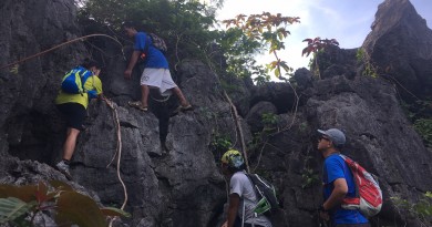
| One of the limestone cliffs that hikers must cross en route to the summit. If you look closely you can see some hikers making the descent. |
TRIVIA
The blogger hiked Mt. Hapunang Banoi on July 27, 2015, his third hiking trip in Wawa after Mts. Pamitinan and Binacayan (February 2015) and Mt. Ayaas (June 2015). His guides were Allan and Ronald.
THE MOUNTAINS OF RODRIGUEZ, RIZAL
Mt. Ayaas

Leave a Reply
3 Comments on "Mt. Hapunang Banoi (517+)"
Personally, there are similarities between Pamitinan and Hapunang Banoi but mas marami ng sobra yung sa Banoi, paid a hard lesson by not bringing any gloves. Shoutout to those we met last Nov 5!
mga 2x more ang haba ng Haponang Banoy sa Pamitinan, sharper ang rocks ska mas magkalayo ung pagitan ng rocks (lalo na sa summit). Para cyang pamitinan & binicayan pinagsama.
Sir Question..compared sa rock scrambling with Pamitinan, are they similar sa difficulty? I have climbed Pamitinan, and I want to gauge yung part ng rock scrambling