
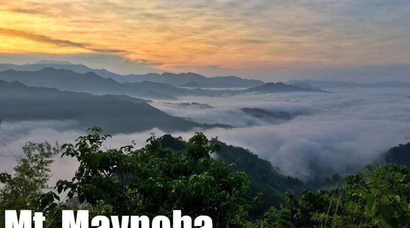
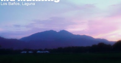
Mt. Maynoba (728m) in Tanay, Rizal

 MT. MAYNOBA (CAYABU-MAYNOBA LOOP)
Tanay, Rizal
Trailhead: Brgy. Cayabu, Tanay, Rizal
LLA: 14°36′22.4′′N, 121°25′18.6′′ E, 728 MASL (+470m)
Days required / Hours to summit: 1 day / 2-3 hours
Specs: Minor hike, Difficulty 3/9 (Summit); 4/9 (Loop hike), Trail class 1-4
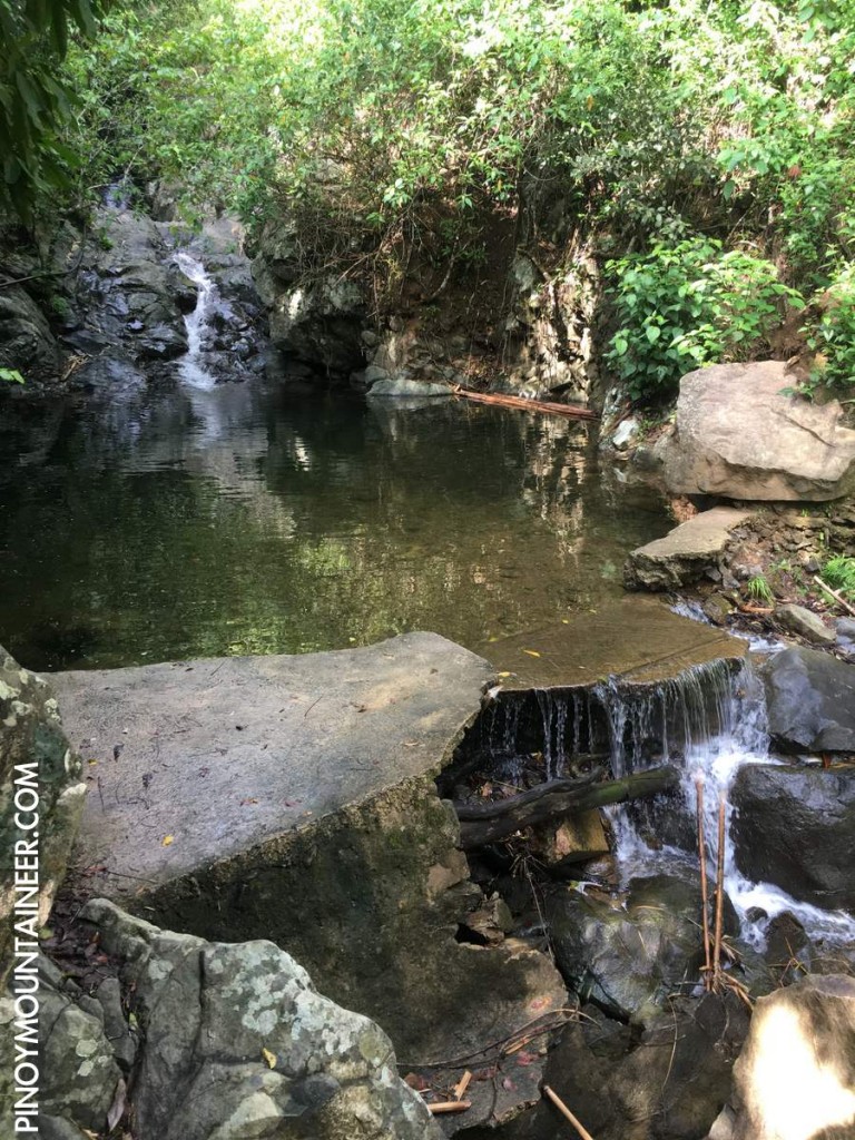
Features: Sea of clouds, scenic views of the Sierra Madre, waterfalls
Article history: Created 4 June 2016 by Gideon Lasco
BACKGROUND
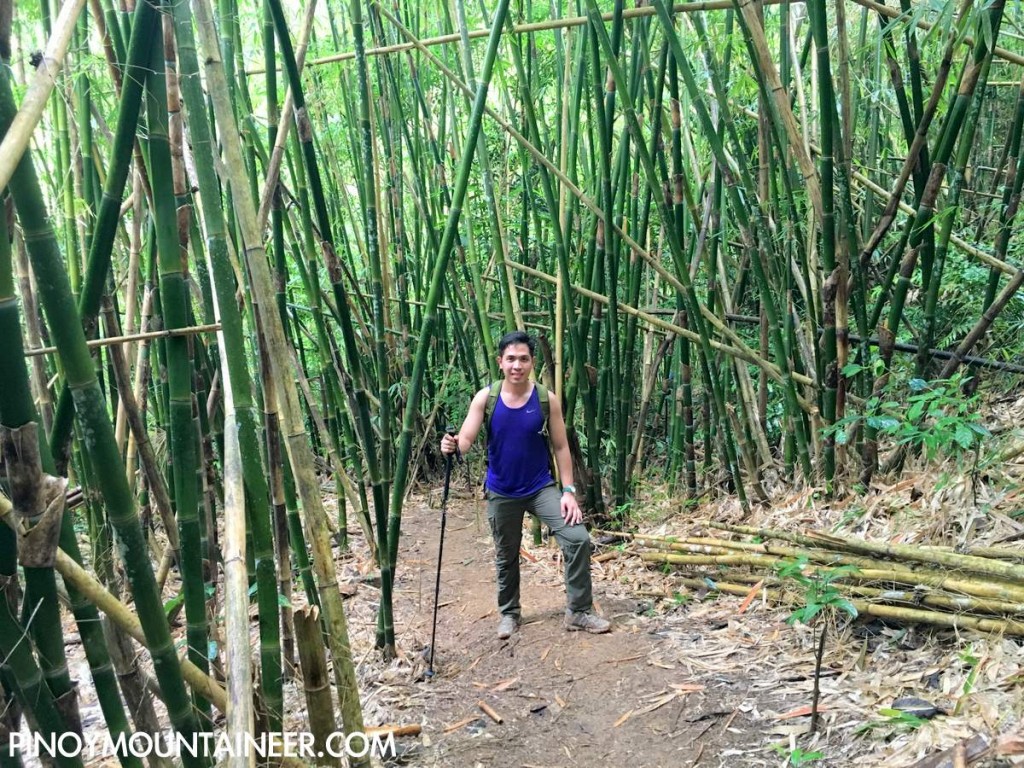
Arguably the mountain with the highest success rate of viewing the sea of clouds of all the Rizal mountains, Mt. Maynoba (pronounced may-noo-ba) was an instant hit from its opening as a hiking destination in early 2016. Easy enough to do in a few hours – and reachable from Metro Manila by private transport in an hour or two, this mountain at the foothills of the Sierra Madre in Tanay, Rizal offers breathtaking views of the Sierra Madre mountains, and enough variety in the trail to sustain one’s interest throughout the loop hike – from a steep, forested ascent up the so-called “Mt. Cayabu” (which is actually more of a subsidiary peak of Maynoba), a grassy, open trek at the higher reaches, and a descent through woodland that culminates in a small river system with a good number of waterfalls.
The trail to the summit, though steep at times, is straightforward, and merits a Maculot-like 3/9 difficulty classification. The hike down the waterfalls, however, has short sections of trekking on rocks, adding to the challenge and therefore increasing the difficulty to 4/9 if doing the entire hike. During the rainy season, muddiness is bound to be an additional consideration.
At the summit, there are beautiful northern views of Mts. Tukduang Banoi and Irid, with the valley of Sta. Ines in between them, and to the east, the Sierra Madre mountains bordering Tanay and the towns of Infanta and Gen. Nakar in Quezon Province. These mountains are scenic by themselves, but they are made much more so when viewing the sun rise above them, with the sea of clouds that for some reason found home in the valleys that surround beautiful Mt. Maynoba.
ITINERARIES
Note: To catch the sea of clouds, private transport is recommended as the public transport schedule will not permit you to reach the trailhead on time. A very early departure from Manila (0200-0300H) is recommended. For van rentals contact 09269702947.
DAYHIKE (PUBLIC TRANSPORT)
0300 Leave Manila for Antipolo (Cogeo Gate 2)*
0400 Take jeep from Antipolo to Batangasan junction
0500 ETA junction. Take tricycle to Brgy. Cayabu
0530 ETA Maynoba trailhead, Brgy. Cayabu. Register / secure guides
0600 Start trekking
0700 ETA “Mt. Cayabu”
0800 ETA “Mt. Maynoba” viewpoint.
0830 Continue with loop hike
0930 Pass through the eight waterfalls. Take a dip (optional)
1030 Continue trek back to trailhead
1200 Back at Brgy. Cayabu trailhead. Lunch / Tidy up.
1400 Head back to Manila
1630 ETA Manila
DAYHIKE (PRIVATE TRANSPORT)
0130 Leave Manila for Brgy. Cayabu via Marcos Highway
0330 ETA Brgy. Cayabu trailhead. Register / secure guides
0400 Start trekking
0500 ETA “Mt. Cayabu”
0545 ETA “Mt. Maynoba” viewpoint in time for sunrise
0630 Continue with loop hike
0730 Pass through the eight waterfalls. Take a dip (optional)
0830 Continue trek back to trailhead
1000 Back at Brgy. Cayabu trailhead. Tidy up.
1030 Head back to Manila
1230 ETA Manila / Lunch
OVERNIGHT (PUBLIC TRANSPORT)
Day 1
1100 Leave Manila for Antipolo (Cogeo Gate 2)*
1230 Take jeep from Antipolo to Batangasan junction
1200 ETA junction. Take tricycle to Brgy. Cayabu
1430 ETA Maynoba trailhead, Brgy. Cayabu. Register / secure guides
1500 Start trekking
1600 ETA “Mt. Cayabu”
1730 ETA “Mt. Maynoba” viewpoint. Set up camp (here or elsewhere)
1900 Dinner / socials
Day 2
0530 Wake up call / Await sunrise
0630 Breakfast / Break camp
0730 Resume trek
0830 Pass through the eight waterfalls. Take a dip (optional)
1030 Continue trek back to trailhead
1200 Back at Brgy. Cayabu trailhead. Lunch / Tidy up.
1400 Head back to Manila
1630 ETA Manila
PRACTICALITIES: MT. MAYNOBA
| Transportation | Public (1) Jeep, Sampaloc to Cogeo [P20, 30-60 mins] (2) Jeep, Cogeo to Batangasan [P40, 60-80 mins] (3) Tricycle, Batangasan junction to trailhead [P25/15 mins]Note: Jeepney travel times are highly variable due to the traffic, but you are likely to get the lower end if you leave very early.Private: Marcos Highway > Brgy. Cuyambay – turn left – follow the road until you reach the trailhead |
| Registration | Logbook at trailhead; P40 fee |
| Guides | Available, required: P500/day |
| Contact numbers | Jeep rental (Rene) – 09127570867 Brgy. Cayabu (Ronald) – 09084330444 Van rental (from Manila) – 09269702947 |
| Campsites and waypoints ⛺ | Campsites: (1) Available between Cayabu and Maynoba highest point |
| Water sources 🚰 | At the start of the waterfalls area |
| Cellphone signal 📶 | Present at the summit and upper reaches. Absent in most parts of the trail. |
| River crossings | Some trekking on or along a stream |
| Roped segments / Technical parts | Unnecessary, but there are fixed ropes or rails in some parts that can be slippery or muddy. |
| Limatik | None |
| Lipa | None |
| Rattan | None |
| Hiking notes | Exercise precaution on the rocky parts of the trail around the waterfalls area. Note that many parts of the trail can be muddy during the rainy season. |
| Sidetrips | Mt. Batulusong Masungi Georeserve en route (reservation required). |
| Alternate trails | Trail to Brgy. San Andres and possibly Mt. Batolusong (not established). Some other trails are being planned to be opened in the same range. |
| Dayhikable | Yes (4-6 hours to complete the whole circuit) |
| Facilities at jumpoff | (+) Sari-sari stores (+) Restrooms / paid wash-up places (20) (+) Parking |
| Estimated budget | P400-500 from Manila |


TRIVIA
According to the local guides, the word ‘Maynoba’ is derived from a plant called ‘toba’ or ‘tuba’ that used to grow in abundance in the forested part of the mountain that terminates in the waterfall system.

Leave a Reply
Be the First to Comment!