
Mt. Ugo (2,150+) Traverse to Mt. Pulag (2,922+)


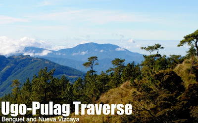
UGO-PULAG TRAVERSE
Benguet and Nueva Vizcaya
Entry point: Brgy. Tinongdan, Itogon, Benguet
Exit point: Babadak Ranger Stn, Bokod, Benguet (+ 2 others)
LLA (Ugo): 16.31916°N, 120.80166°E, 2150 MASL
LLA (Pulag): 16°34’58″N 120°53’15″E, 2922 MASL (#3)
Days required / Hours to summits: 4-7 days / 7-10 (U); 30-40 (P)
Specs: Major climb, Difficulty 8/9, Trail class 1-4
Trail system: Grand Cordillera Trail, Sections 1-3*
Features: Pine forests, mossy forests, villages, hanging bridges, lakes, waterfalls,
Article history: Created January 23, 2013
One of the Top 10 Hikes in the Philippines
BACKGROUND

I am very pleased, at the start of 2013, to unveil an exciting itinerary that features two of the Cordillera’s famous mountains – Pulag and Ugo – and showcases the hidden wonders that lie between and beneath these mountains. The Ugo-Pulag Traverse is also an important connection that paves the way for the establishment of a long distance trail in Northern Luzon, what I would henceforth refer to as the Grand Cordillera Trail (GCT), a trail system from Nueva Vizcaya and Southern Benguet to Mountain Province and beyond, passing through the major peaks of the range. By itself, the Ugo-Pulag Traverse is to Luzon as the Talomo-Apo Traverse is to Mindanao: a long trek or “megatraverse” towards the highest peak, from another prominent mountain. Yet, while the latter is almost purely an interaction with nature, the former is a cultural experience, for it passes through ‘living trails’, paths that people use in their everyday lives.

I am fairly sure that others have done a Mt. Ugo-Mt. Pulag traverse in the past, though there are many ways to do it, and the itinerary I am presenting simply makes sure that you reach Ugo and Pulag in one direction. It requires neither trailblazing nor exploration in the sense of going into the unknown; instead, it beckons the hiker into villages that are largely foreign to the hiking community simply because they are ‘out of the way’. Another impediment is perhaps the lack of people who would like to do longer-distance trails that require more than a long weekend to complete. Nevertheless, as I have discovered when I did this trek, these trails are beautiful, passing through a number of environments, from river valleys to pine and mossy forests; steep ascents on narrow trails to relaxing strolls on roads wide enough for motorcycles to pass through. There are villages, waterfalls, lakes, valleys, peaks, hanging bridges, and even rice terraces along the way; the beauty of the trail is a powerful invitation for hikers to ‘go long distance’, that is, to spend six days on the mountain.

The Ugo-Pulag Traverse has three sections, which can also correspond to the first three sections of the Grand Cordillera Trail. The total trail length is probably 90-100 kilometers. The first is basically the Ugo Traverse, which is very commonly done by local hikers. The only modification for the Ugo-Pulag Traverse is the necessity of doing this section from Itogon to Kayapa, instead of the more customary (and easier) Kayapa-Itogon. The second section is the connection from Mt. Ugo to Mt. Pulag, and passes by at least six villages, as well as the eastern slopes of Mt. Purgatory. It terminates either in Babadak Ranger Station, via the Balete-Babadak Road, or to the grassland summit of Mt. Pulag via Brgy. Napo. Finally, the third section is the standard Pulag hike, via the Ambangeg Trail and returning the same way or completing the section towards Tawangan, Kabayan, Benguet or even Tinoc, Ifugao via the Tawagan Trail.
TRAIL DESCRIPTION: SIX-DAY UGO-PULAG TRAVERSE
Note: I am recommending a six-day itinerary, but it is also very possible to shorten or expand it depending on your preferences. The villages make for good camping spots: they are sure water sources and there is the possibility of staying in the barangay halls or houses.

Day 1: Tinongdan to Mt. Ugo summit
This is essentially also the Day 1 of the regular Itogon-Kayapa Traverse of Mt. Ugo. The trail starts at the hanging bridge in Brgy. Tinongdan, Itogon, Benguet. The ascent is quite rapid, considering the gain of around 1200 meters that must be done within the day. Lusod village makes for a good rest or lunch stop and water source, while the pine forests around the Old Sawmill makes for a good early afternoon shaded walk. Then, as the sun is starting to set, continue with the final assault up the summit of Mt. Ugo (2150 MASL). If you wish to stay in the more comfortable Domolpos village, allot 90 more minutes for the descent. At the summit of Mt. Ugo, don’t miss views of Mt. Pulag, Mt. Timbak, Mt. Sto. Tomas, Mt. Tapulao, and even a distant Mt. Arayat! See Hiking matters #243: Mountain geography lessons from Mt. Ugo.

Day 2: Mt. Ugo summit to Pangawan
From Mt. Ugo summit to Pangawan village which sits at the boundary of Bokod, Benguet, and Kayapa, Nueva Vizcaya. This is an easy day relative to Day 1. A descent from Mt. Ugo summit to Domolpos village is followed by a very gradual, almost flat trail to Indupit village, and from Indupit, one takes a surprisingly mossy forest (with limatik) to reach Pangawan, also known as “Boundary”. Note that the Baguio-Kayapa road passes through here, and there are stores where you can restock on rice and other supplies.

Day 3: Pangawan to Banao village
From Pangawan, there is a rough road used by vegetable trucks, and the trail is reminscent of that of Tapulao: wide but steep in some parts. Attractions include what locals call Buwaca Lake, as well as Dayap village. The challenge of the day is to negotiate the steep switchbacks that lead up to Mt. Ambasa. After that, the trail goes on to pass the first of the hanging bridges that will be nice features of the next day. Another attraction is the beautiful waterfalls that one passes along with some pine forests. After more trekking through rolling slopes, the hiker will reach Banao village (Brgy. Banao), where one can camp for the night.

Day 4: Banao village to Balete village
This is the “Hanging Bridges” Day: several hanging bridges will have to be crossed, some of them long and precarious, but the experience quite memorable. Just three kilometers from Banao is Cabayo village (Brgy. Cabayo), which interestingly sits on the slopes of Mt. Purgatory. According to the locals, it is possible to reach the peaks of Mt. Purgatory via a foot trail; this was also confirmed by my guides in Purgatory who said there is a way to Kayapa. I estimate that it would take half a day to assault Mt. Purgatory as a dayhike (3 hours up; 2 hours down) from Cabayo village. Those wishing to hit Mt. Purgatory as a ‘bonus peak’ may want to advance Day 2 and instead camp in Cabayo to have a chance to do Purgatory. Disclaimer though: I haven’t personally tried out this bonus hike, so it is best to ask the locals about the way, and allot some time allowance.

Past Cabayo village, more hanging bridges are in order, to reach Sitio Abat, a small community that is part of Cabayo. Then, another challenging ascent is required to reach Balete village, northeast. Alternatively, one can descend to Napo village in order to circumvent Ranger Station and reach the summit directly (see Day 5). Another possibility is to connect to Mt. Pullol in Brgy. Salingsingan, Ambaguio then go up Pulag via the Ambaguio-Lusod Trail.

Day 5: Balete to Mt. Pulag Camp 2
One good reason to camp in Balete instead of Napo is the possibility of visiting Dumanling Falls, a spectacular waterfall that plunges right through the valley of pine trees, along the Balete-Babadak Road. After this sidetrip, continue on the road to Babadak. Warning: You might be disappointed with this road that has been widened at the expense of mossy forest. It is long and plodding, used by highland motorbikes and occasional trucks. The trail winds through mossy and then pine forests, and finally through vegetable slopes until you reach Babadak, by mid-afternoon. From there, Mt. Pulag Camp 2, just past the mossy forest line, is 4 kilometers (2-3 hours) away.
Alternate Day 5: Napo village to Mt. Pulag Camp 2
From Napo village, the trail heads up through the mossy forest to connect to the Ambaguio Trail of Mt. Pulag, which will take you to the junction in the grassland summit past Camp 2. This trail is shorter but steeper compared to the Balete route; its reward would be the more pristine state (and off-vehicle) foot trail.

Day 6: Mt. Pulag summit
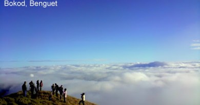
A rewarding, easy day after several days of moderate to difficult trekking, Day 6 involves doing the customary summit assault of Mt. Pulag, either from Babadak Ranger Station or from Campsite 2 of Mt. Pulag, just at the start of the grassland slopes. Traditionally, hikers start early in the morning to welcome the sunrise at the summit: 0430H if coming from Camp 2; or 0200-0230H if coming from the Ranger Station. Definitely the highest peak of Luzon will feel different after a long trek; and those doing the Ugo-Pulag Traverse may have the increasingly rare opportunity to have the mountain all to themselves.
Beyond Day 6: Akiki or Tawangan
Continuing on from the summit of Mt. Pulag, hikers can choose to carry on and traverse Luzon’s highest peak using the Akiki or Tawangan Trails, which just requires one more day to comfortably descend to the exit point (itineraries for these trails are also available in PinoyMountaineer.com; see links below). More possibilities will be offered beyond this point once I’m done exploring Section 4 of the Grand Cordillera Trail. If you are returning via Ambangeg, the hike is practically over by the time you reach the summit of Pulag. If the weather is good, Mt. Ugo is very visible and distinct with its slanted shape (S). You will be amazed at how far it is, and how long the hike has been. Congratulations!
UGO-PULAG TRAVERSE ITINERARY
STANDARD 6-DAY ITINERARY
Day 0
2200 Take bus to Baguio City
Day 1
0400 Arrival in Baguio City. Breakfast / supplies
0500 Take chartered jeep or FX to Brgy. Tinongdan
0700 Arrival at Brgy. Tinongdan. Register at barangay hall
0800 Start trek
1100 ETA Lusod village
1230 Arrival at Old Sawmill; lunch by the pines
1300 Resume trek
1600 ETA Mt. Ugo Summit / set up camp
1800 Dinner / socials
Day 2
0530 Wake-up call
0600 Breakfast / Break camp
0800 Start trek
1000 Arrival at Domolpos village
1230 Arrival at Indupit village; Lunch
1330 Resume trek
1600 ETA Pangawan village /set up camp
1800 Dinner / socials
Day 3
0530 Wake-up call
0600 Breakfast / Break camp
0800 Start trek
0930 Arrival at Nayao Lake
1100 Start hiking up Mt. Ambasa
1230 Lunch past the ascent of Mt. Ambasa’s slopes
1330 Resume trek
1600 ETA Banao village /set up camp
1800 Dinner / socials
Day 4
0530 Wake-up call
0600 Breakfast / Break camp
0800 Start trek
1000 Arrival at Cabayo village
1230 Arrival at Sitio Abat; Lunch
1330 Resume trek
1600 ETA Balete village /set up camp
1800 Dinner / socials
Day 5
0530 Wake-up call
0600 Sidetrip: Dumanling falls
0800 Breakfast / Break camp
0900 Start trek
1200 Lunch along the way
1430 ETA Babadak School
1500 ETA Babadak Ranger Station
1730 ETA Mt. Pulag Camp 2 / Set up camp
1900 Dinner / socials
0400 Wake-up call
0415 Commence summit assault
0530 ETA Mt. Pulag summit (2922 MASL)
0700 Start descent
0800 Back at Camp 2 / Breakfast / Break camp
0900 Resume descent
1030 Back at Ranger Station. Tidy up.
1200 Take chartered jeep down to Bokod
1300 Log out at the Mt. Pulag Visitors Center
1600 Back in Baguio City
1800 Dinner / Back to Manila
PRACTICALITIES
Itinerary planning and disclaimer. The length of the hike will depend on (1) your pace and (2) how much time you want to spend trekking every day. Based on a regular pace, which includes rest stops and all, a six-day itinerary is recommended. However, you can shorten it to four or five days. On the other hand, if you want sidetrips like the Mt. Purgatory via Kayapa bonus dayhike, you may want to allot extra days. I do not guarantee that the itinerary I outlined will work for everyone, but I hope it serves as a helpful guide.
Getting there. Brgy. Tinongdan is now very accessible from Baguio City. A van or jeepney rental will cost from P1,700 to P2,200 (as of January 2013). From the Babadak Ranger Station, a chartered jeepney can take you back to Baguio City. Contact Gina (+639198169234) to make arrangements for both entry and exit rides. For small groups, it is possible to take motorcycles down to Bokod, and from there, take the NA Liner bus back to Baguio City.
Registration and guides. Brgy. Tinongdan collects a P100 registration fee (receipts are issued) and Mt. Pulag National Park collects a P225 registration fee (receipts are also issued). The only guide who is familiar with the entire trail is Alex Basilang, from Kayapa, Nueva Vizcaya. His guide fee is P750/day for this hike. He may be reached at +639219840254. I also strongly recommend that hikers donate P100/person (or equivalent, in terms of useful gifts like medicines) to every village or house where you will stay for the night. As a courtesy, please also inform the Mt. Pulag Park Superintendent, Ma’am Emerita Albas (+639196315402), of your intention to enter the Mt. Pulag National Park.
Hiking notes. Some parts of the trail are steep, others are very gradual, and everything is completely non-technical. Sun exposure can be a problem; prepare accordingly. Take note that hiking time per day may affect performance for the succeeding days; it is not advisable to wear yourself down early on, even if you can physically manage a longer day of hiking. 6-8 hours of trekking per day is advised (as is suggested in the six-day itinerary). Be careful with the hanging bridges, as some may be too hazardous to cross.
Camping notes. Every village has a water source, and also many other parts of the trail. One need not carry more than 2 liters at a time. Cellphone signal may be absent in some of the villages and many parts of the trail especially Section 2 (Pangawan-Babadak). Stores with rice and basic supplies are available in Pangawan and Babadak. It is possible to stay in houses in the villages, but make sure that you will also bring some benefit to the community, or the family that hosted you. Medicines, food, supplies, and donations will be highly appreciated by them.
Sidetrips. Mt. Purgatory in Bokod, Benguet is a very plausible sidetrip from Cabayo village, and from Sitio Abat it may also be possible to reach Mt. Pullol in Ambaguio. Then, from Mt. Pulag, beyond Day 6, Mt. Panotoan and Mt. Tabayoc are both accessible via the Tawagan and the new Panotoan Trail.
UGO-PULAG TRAVERSE PICTURES
 |
| The hike begins: At the barangay hall of Tinongdan, Itogon, Benguet |
 |
| Through the beautiful pine forests of Mt. Ugo. |
 |
| As a ‘living trail’ used by locals in their everyday lives, children ‘trekking’ on the way to school is a common sight. |
 |
| Hanging bridges – 12 of them – must be crossed as part of the traverse. |
 |
| It is very surprising to see that a mossy forest can be found just behind the village of Indupit…with limatiks to boot! |
 |
| This section of the trail near Ambasa is reminiscent of Amuyao Traverse with its beautiful rice terraces. |
 |
| This nameless waterfalls is just one of the many wonders of the trail. |
 |
| Celebrating the successful Ugo-Pulag Traverse in one of Pulag’s peaks, on January 22, 2013. |
TRIVIA
This itinerary is based on my hike through this trail from January 19-22, 2013. This hike will be narrated from Hiking matters #320-323. Even though it is only in 2013 that I finally got to do this traverse, I had been dreaming of it for a long time, as is evidenced with the way I introduced Mt. Ugo in the article I wrote in 2008: “Also, the traverse connecting N. Vizcaya and Benguet is a challenging trail that serves as the southeast entrance to the Cordillera mountain chain – opening possibilities such as a traverse to Mt. Pulag.”
PinoyMountaineer thanks our friend and guide Alex Basilang for accompanying us in the hike from Ugo to Pulag.
MT. PULAG TRAILS AND ITINERARIES
Ambangeg | Akiki | Tawangan | Ambaguio | Ugo-Pulag (Kayapa) | Luzon 3-2-1
MT. UGO TRAILS AND ITINERARIES
Ugo Traverse (Kayapa-Itogon) | Ugo-Pulag Traverse
MT. UGO TRAVERSE TO MT. PULAG
Hiking matters #320: Mt. Ugo Traverse
Hiking matters #321: Indupit – Cabayo
Hiking matters #322: Cabayo – Babadak
Hiking matters #323: Mt. Pulag summit
WEATHER OUTLOOK: KAYAPA, N. VIZCAYA
Leave a Reply
9 Comments on "Mt. Ugo (2,150+) Traverse to Mt. Pulag (2,922+)"
Brother… first time nmn mag Cordillera.. mabuti nabasa nmn to.. ito yung hinahanap nmn… need nmn ng isang guide… pa help nmn… thank u… ps, wala kmi kakilala sa Cordillera…tnx..
Hi Sir Gid, we survived GCT yey! same guide lang din po na kasama nyo, si Sir Alex. and we are proud na nakuha namin ng 4 days (March 28-31,2013)yon nga lang sobrang bugbog ang katawan, halos sumuko na talaga ako dito. so far ito po yong pinaka mahirap na akayat para sa akin. Thanks po and more power.
nice travers, keep it up!
We did this traverse last December 27 to 28, 2012 (two days), as a recce trek for the Hardcore 100 Mile Ultramarathon this coming February 22, 2013.
Hi sir gidz,
I noticed that the trail you used was also the trail where local transportation can pass trough?
So that means, its also possible to that in other mountains as well ?
Like Napulauan traverse to Amuyao?
A hiker can start in Banaue, ride a jeep going to barlig , hike to amuyao, exit in batad , walk all the way to banaue, then turn on the road going to hungduan. Walk all the way to jump off in either hungduan or hapao? Hike all the way up to the summit of Mt napulauan then exit in either exit point then walk all the way to banaue to bus terminal ?
If a hiker can pass trough the villages as you did in your ugu-pulag traverse, then amuyao trav to napulauan is also possible ?