
Manabu Peak (760+)

 MANABU PEAK
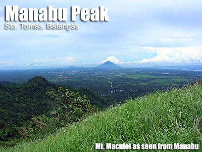
Sto. Tomas, Batangas
Jump-off point: Sulok, Brgy. Sta Cruz, Sto. Tomas
LLA: 13.9777°, 121.2413°, 760 MASL
Days required / Hours to summit: 1 day / 1-2 hours
Specs: Minor climb, Difficulty 2/9, Trail class 1-2
Features: Woodlands, meadowy peak, views of Batangas mountainsBACKGROUND
It’s just two hours to climb, and the peak area is like a beautiful garden. The highest point is marked with a white cross. Grass, as if trimmed by a lawnmower, covers the summit area, and there are flowering plants and shrubs – with blossoms of yellow, red, and pink. During summer months, wild berries called ‘sampinit’ grow on the trails near the peak. They are edible and sweet, like mini-strawberries. This image of an elegant park is exactly the image of Manabu Peak, probably the easiest, most accessible mountain from Manila. Add the beautiful views of the Malipunyo mountain range, as well as Mts. Maculot and Makiling, and it’s picture perfect!
The name Manabu is said to be abbreviated from ‘Mataas na Bundok’. It is one of the three major peaks of the Malipunyo range (the other two are the Malipunyo summit and Susong Dalaga peak). Probably because of its geography, it’s usually cloudy in Manabu, lending an almost nostalgic air. Although Sto. Tomas is a peripheral town of Batangas, the dialect used among the locals in Manabu is distinctly Batangueno. It adds a local flavor to the Manabu experience, much like the homemade kapeng barako which Mang Pirying, owner of the hut midway through the trail, would offer the hikers.
Because of its easy access, short trail, and very beautiful environs, Manabu Peak is a great introduction to hiking for beginners. Even then, veteran hikers rank this mountain as one their favorite ‘fun climb’ destinations – or as part of a more challenging traverse to Mt. Malipunyo.
ITINERARY
0600 ETD Lucena or Lipa bound bus at LRT-Buendia (P90)
0730 ETA Brgy. San Pedro, Sto. Tomas. Take trike to ‘Sulok’
0830 ETA ‘Sulok’, Brgy. Sta. Cruz
0900 Start trek
1000 Reach Mang Pirying’s place
1100 ETA summit.
1130 start descent
1300 Back at jump-off. Proceed back to Sto. Tomas.
1330 Lunch at Rose and Grace restaurant, Sto. Tomas (famous for Bulalo)
1500 Cross the highway and wait for bus back to Manila
1700 ETA Manila
|
Transportation
|
Public (1) Bus, Buendia or Cubao to Lipa, Batangas [2 hours; 132 pesos]
(2) Tricycle, Lipa to Sulok, Brgy. Sta Cruz [100/trip; 30 minutes] *The tricycle terminal is at the Fiesta Mall junction. Ask the bus conductor to drop you there, or if it passes by STAR Tollway you might have to take a tricycle from the bus terminal to the tricycle terminal*Alternatively, take any Lucena-bound bus and get off at Brgy. San Pedro, Sto. Tomas and take a trike to Sulok, Brgy. Sta Cruz. Expect to pay a lot more for the trike (P250/trip) Approximately 3 hours travel time because of various stops and delays. Private. Take SLEX and follow through to STAR Tollway, exit at Lipa-Tambo, and follow the highway back to Lipa. Go past Robinsons Mall until you see the Fiesta Mall junction. Turn right there, follow the road, and make a left turn to the road that leads to Sto. Tomas. Make a right turn at Brgy. Sta Cruz and ask the locals for the direction to the narrow road that leads to the trailhead where parking space available. |
|
Registration
|
(1) Logbook at the barangay hall. P20 registration fee.
|
|
Available at the trailhead but not required (500 pesos for the dayhike; 1250 for overnight)
|
|
|
n/a
|
|
|
Campsites and waypoints
|
Summit campsite is spacious and can fit > 20 tents
|
|
Water sources
|
Several; available at the rest stops
|
|
Cellphone signal
|
Present through most parts of the trail
|
|
River crossings
|
Small stream near the start of the trail with minimal risk of flooding
|
|
Roped segments
|
None required but some ropes are set up in the final assault to assist hikers as the soil might sometimes be slippery
|
|
None
|
|
|
Minimal
|
|
|
Rattan
|
None
|
|
Hiking notes
|
|
|
Sidetrips
|
From the summit, it is possible to make a loop hike passing by the ‘Grotto’, which features slightly more challenging, forested trails with some rattan. Manabu Peak is often done as a ‘Twin dayhike’ with nearby Mt. Maculot.
|
|
Alternate trails
|
It is possible to traverse to or from Mt. Malipunyo (see an account in Hiking matters #354)
|
|
Yes (2.5-4 hours to summit; 1.5-3 hours down on either of the above-mentioned trails)
|
|
|
Facilities at jumpoff
|
(+) Sari-sari stores
(+) Wash-up / shower places (+) parking |
|
500-700 (dayhike)
800-1000 (overnight) |
MANABU PEAK PICTURES
 |
| Enjoying coffee at the Mang Pirying’s Hut at Station 5 |
 |
| Some parts of the trail are nicely forested |
 |
| Mountains that can be seen from the summit |
 |
| The summit is marked by a cross |
TRIVIA
The author met Mang Pirying on his first climb to Manabu Peak in 2004, during which he showed him and his companions the right direction to the peak. Three years later, in Feb. 2007, he dropped by the hut again, and Mang Pirying remembered him! “It’s good that this time you didn’t get lost,” he quipped.
PINOYMOUNTAINEER IN MALIPUNYO RANGE
Hiking matters #3: Oops, wrong mountain!
Hiking matters #80: For the love of coffee and fresh mountain air
Leave a Reply
322 Comments on "Manabu Peak (760+)"
Update sa transpo at reg. fee:
Buendia to Fiesta Mall, Lipa (Green StarExpress Corp) – 120.50
Fiesta Mall to Sulok Jump-off – 40.00 (3/tric)
Registration – 20.00
Sulok Jump-off to SM Lipa – 40.00 (3/tric)
SM Lipa to Buendia (DLTB) – 122.00
Sabihin nyo sa Tric Driver na idaan kyo sa registration area.
Wala sa Jump off ang registration.
Bago mkarating, mdadaanan nyo un.
Pwede dn kayo mgpaluto ng tinolang Native chicken sa jump-off pra sa pagbaba nyo.
Umakyat kami last feb 6, 2015 ng around 8:30pm.
Malakas loob naming thinking na established ang trail and walang ligaw kasi sabi may mga signs na sa trail. Unfortunately NALIGAW kami..
Advise lng po sa mga magnnight trek, medyo nakakalito ung trail especially kung first timer.
Naligaw kami dun sa part ng after ng may barb wire. Left turn dapat, then mpupunta kyo s open field, then wala ng sign at all.. gabi un at d nmin nkita ung mga barb wire na bakod. Meron pla dun n open, meaning dun ang daan..
Pero since di nmin un nakita, bumalik kami and pumunta kmi sa right turn..which lead us to nowhere..
after 1hr trekking, trying n makakita ng summit, ngdecide kmi twagan ang contact n nsa blog, pero out of coverage, that was 10:30pm already..
so we decided n twagan ang isa p nming kamember n supposedly e the next day pa susunod samin. pinunthan nya kami to get guide n rn sa mga tric driver.
habang pababa kmi, may nkasalubng kmi n family (husband and wife with 2 kids).. alam nila ang trail dhil nkaakyat n sila dun. pero di n kmi sumama kc naisip namin n mwwlan ng ksama ung pinapunta nming kamember.
pero nung pababa n kmi, maya maya nakita namin sila ulit, pababa din..di n rn nila Makita ung tamang trail..so sabay sabay kmi bumaba.
pgdating sa may barb wire, ngdecide ung family na itry ulit umkyat, cguro nakita na nila ung trail..pero kmi tumuloy n sa jump off.
nkablik kmi sa jump off ng around 11:30pm.around 12:30am dumating ung ksama nmn with the 3guides.. 1am kmi ngstart ng trek ulit at nkarating sa summit ng 2:30am.
along the trail, dun sa isang kubo n may halo-halo, nlaman nmin n nkadaan n ung pamilya..so meaning nakita n dn nila ung tamang trail..
Hi. We're climbing Manabu tomorrow. See you around guys! Just say hello. -ROAN
This is my first time to go hiking, indeed, Mt. Manabu suits for beginners.
Very very nice view at the peak, especially the city lights 🙂
We also meet solo hikers there…
Galing po kami Manabu noong oct 5, 2014
Tatay tino is doing great.sabi nia wag na daw namin daanan ung kabilang trail(grotto) dahil madami daw nakaharang na rattan.