
Mt. Maculot – Rockies (706+) and Rockies-Summit-Grotto Traverse (930+)


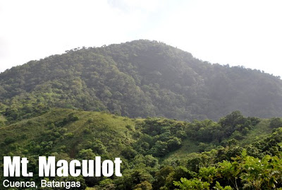
MT. MACULOT
Cuenca, Batangas
Major Jumpoff: Mountaineer’s Store, Brgy. 7 “Siete”, Cuenca
Exit point (traverse): Brgy 5 (to Grotto), Cuenca
LLA: 13°55 N; 121°2 E; 706 MASL (Rockies) / 930 MASL (summit)
Days required / Hours to Rockies / summit : 1 day / 1-2 hr / 2-4 hr
Specs: Minor, Difficulty 3/9 (Rockies); 4/9 (Traverse) Trail class 1-3.
Features: Scenic views of Taal Lake, rock formations, forests
Posting date: August 9, 2007
Last updated: November 17, 2015
November 2015: Guides are now required, P400 for the Rockies for 1-5 persons. For more updates on guide fees, please click here.
Mt. Maculot is one of the most popular daytrip destinations. It is so popular that on weekends and summer months, there is a sari-sari store, dubbed ‘7-11’ at the campsite. This mountain, at the heart of Batangas, is known as a landmark for locals and travelers alike; it is easily identifiable because of its abruptly terminating east side – forming a cliff that is challenging for rock climbers and breathtaking to everybody else. Others describe the shape of the mountain as ‘igloo-like’.At 930 MASL, the mountain has three destinations: the famous Rockies (706m), the summit (930m) and the Grotto (510m). These can all be covered by a traverse dayhike, but most climbers head to the Rockies, which is the reason why Maculot is the paragon of an easy hike. Only 5% of hikers pursue the traverse, but we hope more people will explore the “forested side” of the mountain.
Moreover, there is a big store, dubbed ‘7-11’ at the campsite which marks the end of the initial trail: this store offers everything from hard drinks to halo-halo and is open on weekends and peak season days during Holy Week etc. The campsite has space for 20 tents or more, but if you are a seeker of peace and quiet on a mountain on weekends, this is probably one of the worst places to camp in, being full of people, some of whom can get rowdy and noisy well into the night, talking and drinking. On weekdays, though, Maculot is very pleasant and quiet. Also, because of its popularity, Maculot has historically been dubbed one of the mountains with the dirtiest trails and campsites – a notoriety that has since been improved by clean-up climbs and an increasingly responsible hiking culture; nonetheless, garbage remains a big problem, and has diminished the beauty of the mountain.
Arriving at the campsite coming from the jumpoff, there are two trails, the left one leads to the Rockies, five minutes away; the right one leads to the summit, which is visible and prominent the campsite. For adventure seekers wishing to maximize a day or two of hiking, Maculot has plenty to offer beyond the Rockies. From the campsite, one can continue to the peak (930 MASL) and the Grotto on the other side of the mountain.
The trail to the summit, and past it, is mostly forested, and lends a different flavor from the usual Maculot trail. Some parts of the trail may be overgrown but is not difficult to follow through the long-established trail. It takes about an hour or so to reach the summit from the Rockies, and there, 930 MASL – the second highest point in Batangas – one can see the Rockies partially surrounded by the waters of Taal Lake; and Taal Volcano too visible and you can take a peek of the Crater Lake itself.
From the very summit of Maculot, there are two trails: one that follows the trail of origin, and another than goes down right from the summit, which is also the right side of the summit, when you’re turning your back from the Rockies. Follow this trail, which gets quite steep (and there are some roped segments). The forest ends where the Grotto emerges, and from the Grotto, there are stations of the cross that follow you until you reach the end of the trail. The traverse, like the regular climb, is a relatively straightforward climb, and is doable for reasonably fit individuals.
Either way – as a traverse or as a regular climb – Mt. Maculot is a very nice climb, and its popularity is understandable. This used to be one of our highly recommended dayhikes from Manila, but as of 2015, we are concerned about the mismanagement of the place: the summit was “shaved” in November 2015 to give way to a “better view”.
0600 Board Lemery-bound bus from Buendia or Cubao (~P130)
0900 ETA Cuenca Poblacion – Highway. Walk or take trike to jump-off.
0930 start trek
1115 arrive at campsite, head to Rockies
1130 at Rockies; take pictures
1200 return to campsite for lunch
1230 start descent
1400 back at jump-off; tidy up then head back to the highway from Manila-bound bus.TRAVERSE (Rockies-Summit-Grotto)
0500 Board Lemery-bound bus from Buendia or Cubao (~P130)
0800 ETA Cuenca Muncipal Hall. Walk or take trike to jump-off. Pay P10 registration fee.
0830 start trek
1000 arrive at campsite, head to Rockies
1010 at Rockies; take pictures
1110 Leave for the summit
1230 ETA Summit of Mt. Maculot. Lunch
1300 Start descent to Grotto
1430 Arrival at Grotto. Rest.
1445 Resume descent.
1600 Arrival at exit point.
0600 Board Lemery-bound bus from Buendia or Cubao (~P130)
0900 ETA Cuenca Poblacion – Highway. Take trike to “Grotto at Brgy. 5”
PRACTICALITIES: MT. MACULOT
|
Transportation
|
Lemery-bound bus from bus terminals in Cubao (MRT3: Cubao; LRT2: Cubao) or Buendia (LRT1: Gil Puyat) [150-160; 2.5 hours]. Alternatively, one can take a bus to Lipa then take a jeepney to Cuenca (P28). Ask the bus or jeep to drop you off at Poblacion (town center) along the highway. From there, you can either walk to the jumpoff or take a tricycle [15/person]. The tricycle will detour you to the Barangay Outpost.
|
|
Registration
|
Logbook at barangay outpost. Total fees per hiker: P20
|
|
Mandatory as of January 2015: P400/5 persons/day for the regular trail and P1000/5 persons for the traverse. Click here for latest updates
|
|
|
(1) Barangay Outpost – +639103172853
(2) Cuenca Police Station – (043) 342-9952
|
|
|
Campsites
|
Wide campsite 5 minutes away from Rockies
|
|
Water sources
|
None
|
|
Cellphone signal
|
Present throughout the trail
|
|
River crossings
|
None
|
|
Roped segments
|
None
|
|
None
|
|
|
None
|
|
|
Rattan
|
None
|
|
Hiking notes
|
Although taking less than 10 minutes, the trail from the campsite to the Rockies is very steep. Beginners must be assisted during this leg of the trip. There is a brief portion where you need to scramble up the rocks, some of which may hit you on the head if you are not careful during the ascent.
|
|
Sidetrip
|
Twin dayhike with Manabu Peak (see itinerary here)
|
|
Alternate trails
|
Traverse via Grotto (though sometimes this is officially closed)
|
|
Yes (2-3 hours to summit; 1.5-2 hours down)
|
|
|
600-900
|
ADDITIONAL CONCERNS
Security concerns. Mt. Maculot is generally safe, and in the past years, we’ve had no reports of any untoward incident involving hikers. However, since it is a popular place, there are a lot of campsite in the campsites so caution is advised.
Environmental concerns. Mt. Maculot is one of the most popular mountains in the whole Philippines, and as such it has been grossly commercialized. To reduce impact on this mountain, PinoyMountaineer suggests avoiding camping in the weekends, or minimizing group number to 15, and whenever possible, bringing down trash from the campsite. Moreover, PinoyMountaineer does not advice hikers to buy refreshments from stalls on the trails, as this would encourage further commercial activities on the mountain itself.


The scenic view at Mt. Maculot’s Rockies is the mountain’s most spectacular attraction. This picture was taken in February 2007.


At the Rockies, with Ms. Agot Isidro (Feb 2012)


TRIVIA
Batangas folk continue to tell their children that if they don’t comb their hair before they sleep, “the kuto (head louse) will take them to Mt. Maculot!”. Another variation of this anecdote claims that there’s a giant louse that lives in Maculot. It is also said that curly-haired aborigines (Aetas) once lived in this mountain, hence it was named Maculot from “kulot”, meaning curly.There are only a few cases of hiking-related accidents in Mt. Maculot. One, involving a girl climber, was a case of falling from the Rockies in the 1990s.Although less than 1000 MASL, Mt. Maculot can actually be seen from Puerto Galera and parts of Northern Mindoro.
Leave a Reply
453 Comments on "Mt. Maculot – Rockies (706+) and Rockies-Summit-Grotto Traverse (930+)"
Up kay Sir Paul na nagbigay ng info kay Sir Flor na nag-guide samin sa Maculot na dapat ay traverse from Grotto.
Sa kasagsagan ng Ineng at Habagat kami umakyat ngunit marami ang pumigil samin kasana na si kapitan na nag-offer din samin na mag-overnight sa barangay na may aircon pa. Sa kaligtasan ng karamihan, hindi na kami nagpasyang tumuloy ngunit pinrisinta na rin ni sIr Flor na umakyat ng Grotto dahil sayang nga naman ang byahe namin. Halos ang lakas ng hangin at pabugso-bugsung ulan ang sumalubong samin. Kakaibang experience ang naranasan ng bawat isa. Kumbaga na experience namin yung 'expect the unexpected'. Sa kabutihang loob ni Sir Flor inanyayahan nya kaming mag-overnight na lang sa kanyang mansion. May libre pang hapunan (nilutuan nya kame ng laing), rambutan, lansones at takeout pang saba at mangga. Ikaw na lang ang mahihiya sa kanya at sa kanyang pamilya.
Tama nga si Sir Paul na donasyon lang ang hinihingi ng mga guide sa Brgy. Pinagkaisahan at sana'y makatulong yung ipinalit namin sa kabutihang loob nya at ng kanyang pamilya.
Post ko na din yung contact ni Sir Flor (Florante Hidalgo): 09204834145/ 09056693654
Mabuhay at masyang paglalakbay sa lahat,
Lance
tama.. grabe nga sila maningil ngayong sa mt maculot. nag overnight kami ang singil samin 800pesos.. wala kaming pero kundi 600.. hindi naman kasi namin alam na may guide na pala don dahil nung huling umakyat kasama ko wala silang guide.. yung guide na nagkataong natapat samin ayaw pumayag ng 600 pesos lang ang bayad. buti nalang may nagmagandang loob samin si christopher "pepe" calapati.. tinangap nya yung 600 pesos na binayad namin binilihan pa kami ng tubig sa campsite dahil kinapos kami.. hindi don natatapos yun magandang kalooban nya. pag baba namin ng bundok nag stanby kami sa tindahan at nag order sya ng tig iisang spagetti at tinapay.. parang don lang din na punta yung binayad namin sakanya.. kaya sa aug 15-16 aakyat kami ulit don at babawi kami sakanya..
Blessing in disguise yung nangyari samin. Bali hindi talaga namin alam kung anung brgy yung nakakasakop sa Mt. Maculot kaya sumugal nalang kami baka sakaling alam ng mamang driver sabi namin ibaba kami sa cuenca batangas sa may Mt. Maculot. Nagkataon naman na binaba kami sa Cuenca bayan (Traffic daw kung tawagin yung lugar na yun) tapos sumakay kami ng tricycle papuntang jump off tapos ang binabaan samin ng driver ng tricycle ay sa brgy. pinagkaisahan ng cuenca batangas. Eto yung end point pag nag traverse ka from barangay syete (rockies>summit>groto). Required din ang guide dito pero not like sa barangay syete na 1000 pesos ang guide fee dito ang mag guguide sayo ay mountain rescue unit ng barangay nila at ang pinaka maganda dun ay DONATION lang yung guide fee nila at hindi sila naniningil kung anu lang yung bukal sa loob mong guide fee. Pangalan nung nag guide samin ay si Sir florante mabait sya he offered us a free buko before kami umalis sa bahay nila(Madadaanan nyo yung bahay nila bago kayo magsimula) he even introduce us to his wife and two children. Dahil first timer yung kasama ko at nakita ni sir florante na medyo hirap yung kasama ko he offered na sya nalang magbubuhat ng gamit nung kasama ko. tapos nung nasa kalagitnaan na kami ng trail nasira naman yung sapatos nung kasama ko at to my surprise meron syang dalang pang tahi ng sapatos at tinahi nya yung sapatos ng kasama ko, tinanong ko kung anu pa bang laman meron yung magic bag nya sabi nya meron din daw syang lubid at first aid kit dun. Oks si sir florante smooth sail yung akyat namin sa mt. maculot. anyways ang magiging IT nyo pala pag nagsimula kayo sa brgy. pinagkaisahan ay (Grotto>summit>rockies) pero kami hindi na kami dumaan sa 1500 steps ng grotto instead ay dun kami sa forest part ng mountain dumaan para di namin ramdam yung init at hirap sa pag akyat ng hagdan, Di sa naninira ako sa mga guide ng brgy. Syete pero may nakasalubong akong group nag overnight sa mt. maculot tinanong ko yung guide fee nila kung magkano nagulat ako 2300 pesos daw singil sakanila. Grabe naman sila sa mga mountaneer akala ba nila mayayaman lahat ng naakyat ng bundok? anyway kung interested kayo mag paguide sa barangay pinagkaisahan iwan ko nalang number ni sir florante sabihin nyo nalang si paul yung nagbigay. 09204834145. pito lang silang guide dyan(Trained rescue team ng barangay nila) kaya mas maganda siguro mag text muna kayo, 🙂
^Bro, may kopya ka ng kasunduan na yan?
Padala natin sa ombudsman kung gusto mo.
Tulungan kita.
😀
Good day Mountaineer!Napaka panget ng naexperienced ko sa lugar na to kahapon. Napakadaming abusadong mga tauhan ng tauhan mula sa brgy nila hanggang brgy CAPTAIN nila. Bago kame pumunta dun,kumuha na kame ng idea/information through social sites. Yung 10 pesos na registration fee na nakalagay dito, pag dating sa outpost nila naging P20 pesos na. At pinaka matindin eh pinipilit kaminng mag bayad ng P400 para sa tour guide. Though wala naman kaming alam na meron palang REQUIRED na ganun, Sa totoo lang ngayonlang ako nakaencounter ng ganitong lugar na kung saan pipilitin ka mag bayad ng P400 pesos para sa tour guide, At dahil sa tumanggi kaming mag patour guide dun pa lang sa outpost nag karoon na nag sagutan sa pamimilit nilang KAILANGAN DAW! (e pano kung naka budget ang pera namen papunta dun? Di nila kame papayagan umakyat?) Choice mo ang magpa guide o hindi, bat mo pipilitin? So, Sa pag tanggi namin na mag bayad sa outpost ng P400 sa para sa tour guide, habang paalis na kame isa sa tauhan ng brgy ang humabol sa tryvle na sinasakyan namin at pinahinto sa harap ng bry CAPTAIN. (dahil tumanggi kami mag pa tour guidde at magbayad ng 400) Sa bahay ng CAPTAIN MISMO lumabas sya at same scenario pinipilit kame maglabas ng pera para daw sa kapakanan namen sabay sabing "imposibleng wala kayong dalang pera (alibi namin sa kadahilanan na ayaw namin maglagay sakanila) Galing kayo ng Maynila kahit isang kusing wala kayo? Sa totoo lang hindi sa akin napupunta ang pera na yan , kundi sakanila din (hmmm…) Delikado sa bundok at kung di kayo magbabayad, wala kaming responsibilidad sa inyo." (wow as in wow) Yung ganun pakikitungo sayo ng isang opisyal ng kanilang brgy magdududa ka talaga, Parang kasing naging PRIVATE MOUNTAIN ang Mt. Maculot ngayon na akala mo e, di ka makakaakyat pag di ka nag bayad sakanila. Nag talo talo ang usapan at Nagdecide nalang kame na babalik dahil sa mga panenermon ni Mr. Crispin (Brgy. Captain nila) pero sa isang kondisyon, Kukunin ko lahat ng pangalan ng mga tauhan nyang humarang sa amin sa tricyle at ang buong pangalan ng kanilang Brgy. Captain. Nairecord ko ang conversation namin through video.(voice record pero maririnig mo ang sapilitan pag hingi ng P400 at nung sinabi kong "kelan pa nging required ang pag papatour guide sa bundok?" ang sagot nya "PINAREREQUIRED ko BAKIT??!" Hanggang sa tumagal ang usapan namin at ang P400 bumaba sa P200 pesos, dahil sinabi namin 200pesos ang extra money namin para sa tubig, at sabay sabi nyang "Eh 200, makakapag bigay kayo?" Nauwi sa waiver ang usapan dahil sa nangyareng ayaw namin mag lagay kahit P200, pinayagan nya pa din kaming umakyat sa BUNDOK NYA sa pamamagitang ng isang kasunduan wala silang responsibilidad o gampanin sa anumang aksidenteng mangyayari kung sakaling maligaw kame sa kanyang pag aaring bundok.Napapayag sya dahil sa katanungna kong kunin ang pangalan nya at ng mga tauhan nya. Kung gaano kaganda ang lugar sa tuktok ganun nalang kapangit ang mga ugali ng iilang tao dito dahil sa pera. Inaangkin ng mga opisyal ang bundok at kelangan matutukan ito ng mga kapulisan sa lugar ang ating Gobyerno.